Comments: (3)

MetaMap | Interview with Christian Nold on his mapping projects

Category: ⚐ EN+art+city+creativity+landscape+MetaMap+technologies

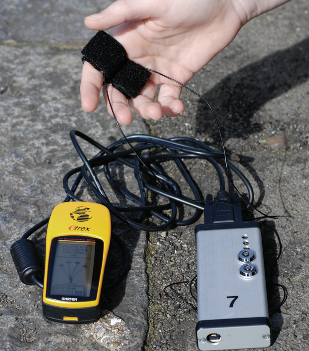
Biomapping device and GPS

Today, I present the interview with Christian Nold where he shares his experience with mapping projects such as Bio MappingGreenwich Emotion Map, and SanFrancisco. He describes himself with the following:

Christian Nold is an artist, designer, and educator working to develop new participatory models for communal representation. In 2001, he wrote the well received book ‘Mobile Vulgus’, which examined the history of the political crowd and which set the tone for his research into participatory mapping. Since graduating from the Royal College of Art in 2004, Christian has led a number of large scale participatory projects and worked with teams on diverse academic research projects. In particular, his ‘Bio Mapping’ project has received large amounts of international publicity and has been staged in 16 different countries and over 1500 people have taken part in his workshops and exhibitions.
In 2007, Christian Nold founded Softhook Design, which is now providing large scale public discussion projects, such as the TownToolkit. Christian Nold teaches at the Bartlett University, College of London and is a guest lecturer at Aalborg University of Denmark and an active member of the Council for the Internet of Things.

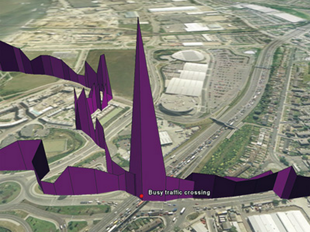
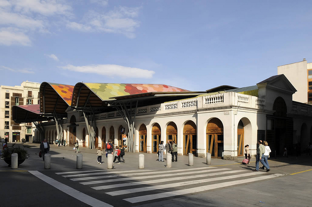
Galvanic Skin Response in a busy traffic crossing

1. How did you get to the practice of mapping? 

Mapping for me is a way to understand shared places. I entered this area through psychogeography and the idea that there might be shared psychological and unseen, but political structures that underlie the physical environment around us. Mapping then becomes a way of trying to record this kind of exploration. The shared mental and physical spaces, which are shaped into the form of a map, are such a familiar way of recording spaces that we can all access.

2. In what way do you obtain and treat the data for your mapping?

I utilize different types of mapping in my work, but my main interest is trying to articulate the blend of space between mind and material. The sources of my data tend to be ambiguous, such as physiological arousal, smells, sounds, feelings of being in or out of control, or illicit behavior.  My real interest is trying to map things that are difficult to map, or for political reasons, are not being mapped at all.

3. What is the application of open source mapping you are interested in the most?

What interests me about open source mapping is the way it provides agency for people to redefine how things are done.  The openness allows people to redefine mapping in terms of what is being mapped, as well as how to do the mapping.

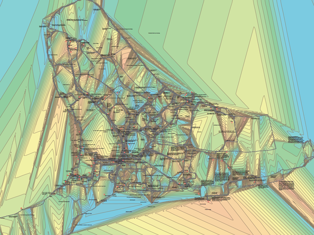
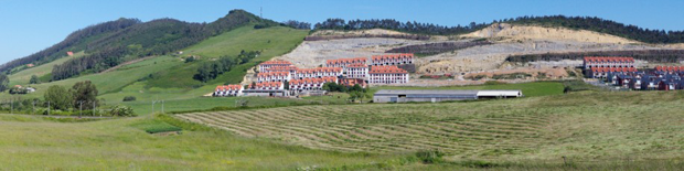
Greenwich emotion map

4. What is the next phase of development your research is undergoing?

I’m currently researching whether mapping is a device ethnography at the Extreme Citizen Science Group at UCL.  This means I’m trying to trace networks of knowledge and power being generated by sensing devices and trying to map and articulate what is going on there. The final results will not be maps, but will utilize the methodology and thinking of mapping to uncover the relationships between entities, which I think is the core of what mapping is truly about.

5. What are you personal references for the theme of mapping (from ancient to contemporary ones)?

 I love some of the pre-modern maps that blend stories and myths, as well as local plants, flowers, and animals that simultaneously describe the physical environment.  Many of those maps show a freedom of blending together and crossing between categories that you don’t see any more in modern maps. Nowadays, maps seem to focus more on what they exclude rather than focusing on what they represent.

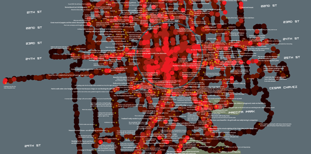
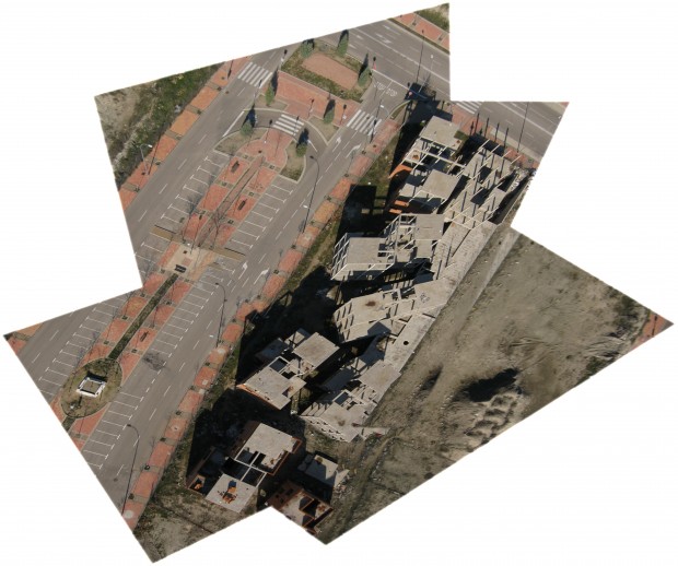
San Francisco emotion map

You can see related posts in the metamap series.

Comment: (1)

Equipamientos domésticos ecológicos, autoconstruibles y abiertos | Los Agrodomésticos

Category: #follow+#followarch+⚐ ES+diseño+urban social design+urbanismo

Para acabar la semana con algo fresco, interesante y entretenido, os presento los Agrodomésticos, una propuesta dentro del proyecto Agronautas de PEZestudio, que han presentado recientemente con el vídeo que dejo más abajo, y que posiblemente hayáis visto ya por las redes sociales.

¿Qué son los Agrodomésticos? Son equipamientos ecológicos domésticos, innovadores, autoconstruibles y de código libre. Los Agrodomésticos reducen el consumo de energía y recursos y pueden adaptarse a cualquier espacio habitable (vivienda, espacio público, etc). Funcionan como herramientas para generar nuevas prácticas asociadas, más resilientes y sostenibles.

En el vídeo podéis ver en uso el “horno solar parásito” y el “refrigerador botijo”:

Los Agrodomésticos son parte de una nueva fase del proyecto Agronautas llamada Nuevas Realidades Urbanas, que consiste en la generación de herramientas creativas que formalicen y transmitan al imaginario colectivo situaciones y prácticas verídicas en entornos urbanos, reformuladas en términos de sostenibilidad y procomún.

Si os pica la curiosidad sobre Agronautas, podéis explorar este documento:

También podéis seguir la conversación en Twitter (y en otras redes sociales):

#agrodomésticos + #agronautas por @pezestudio

¡Buen fin de semana!

Comments: (6)

Ciudades del Mañana: Acción Hoy | Propuestas y conclusiones de URBACT en 7 informes

Category: ⚐ ES+sostenibilidad+urbact+urbanismo

La serie de informes temáticos de URBACT “Ciudades del mañana: Acción hoy”, consiste en 7 publicaciones y es el resultado más importante del proceso de capitalización de URBACT II. Estos documentos permiten difundir el conocimiento generado desde la colaboración entre ciudades durante el desarrollo del programa, y están pensados como guías que incluyen reflexiones teóricas, estudio de casos y recursos prácticos que las ciudades europeas pueden aprovechar.

Ciudades del Mañana

Los 6 informes principales, resumidos en un séptimo documento resumen, tratan los siguientes temas: el desarrollo urbano integrado y sostenible, los retos y oportunidades de las ciudades en recesión, la relación entre empleo y ciudad, el apoyo a la juventud a través de la innovación social, la lucha contra las ciudades divididas, la creación de una nueva mentalidad sobre la movilidad y la eficiencia energética de los edificios en las ciudades europeas. continue reading

Comments: (0)

Festival Internacional de Arte y Construcción IFAC 2013 | Covarrubias, 5-14 agosto

Category: ⚐ ES+arquitectura+eventos+sostenibilidad

IFAC 2013

Si aún no habéis hecho planes para el verano, el Festival Internacional de Arte y Construcción, que se celebrará este verano en Covarrubias, Burgos, puede ser una buena oportunidad para cambiar de aires, conocer gente y poner vuestro lado creativo en acción.

Conocemos gente que viene desde bastante lejos para participar en este evento, donde nada menos que 250 participantes convivirán durante 10 días, participando en 20 talleres constructivos, artísticos y teóricos. De forma paralela, en el mismo sitio tendrá lugar un festival de música y de cine, y muchas otras actividades relacionadas con la arquitectura desde la perspectiva de la autosuficiencia y la bioconstrucción.

Os dejamos con un teaser de lo que se respira durante esos 10 intensos días:

Toda la información: www.ifac2013.com

Comments: (0)

MetaMap | 6000 km by Basurama, interview with Pablo Rey

Category: ⚐ EN+city+internet+Intervista+landscape+MetaMap+urbanism

Basurama is a forum for discussion and reflection on trash, waste, and reuse in all its formats and possible meanings. It was born in the Madrid School of Architecture (ETSAM) in 2001, and since then, has evolved and acquired new shapes.

Tire Cemetery in Seseña (Toledo)

I interviewed Pablo Rey Mazón, member of Basurama, about 6000km, a project about the concept of trash applied to new constructions and land use, the metabolism of the city.


1. How did you get to the practice of mapping? What led you to the practice of mapping?

We use mapping, a geo-spatial representation of things, to understand and display complex situations. Maps have always been interesting to me: subway maps, the Callejero (the streetmap book from Madrid), and later in architecture school, I was using and producing maps quite often. Google Maps and Google Earth came later…. maps are one special part of all the data visualizations tools available.
I have also participated in the development of meipi.org, an open source software for collective geo-location of information (texts, photos, videos, and audio) online, that we have used in many projects.

Interface of the map - Click to see original at Meipi

Interface of the map – Click to see original at Meipi

2. How did you choose the object of your mapping?

A map is a tool to decode certain information. Depending on the project, we would use one visualization or another. When we’re interested in the location of things, we use maps. In Basurama, we’ve used maps for many different projects apart from 6000km:

-Mapping urban metabolism landscapes (panorama photos) + real estate bubble: map, tactics in 6000km

-Mapping reusable waste in Ruhr (Germany) map 1map 2how to

Flow of waste in Mexico City

Exchange of objects map

In Ruhr, we used geo-located photos that we took, and a special instance of Meipi, to show the location of possible reusable waste. In spermola.org, we tried to give the opportunity to exchange an object by providing information about where the object was.

6000km started as an exhibition of 10 big format panorama photos from the Madrid outskirts: landfills, highways, scrapyards, and abandoned places. The project was part of the exhibition and was named Basurama Panorámica. It shows the public different places to envision the consequences of the urban expansion that was occurring at the time. Each photo had a short text attached to it, that served to contextualize and give basic information about it. We didn’t just want ‘awesome’ photos, we wanted to make people understand where and what those locations were. The exhibition had two related maps: urban growth and highways, apart from a location map of all the photographs. Displaying urban developments together with landfills and empty toll highways was the way to show the relation among all the urban metabolism related situations. Empty buildings made for speculation purposes where as waste made for scrapyards. That was 2006, 2 years before Lehman Brothers declared bankruptcy.

Later on, when we addressed this project in a country scale we studied and mapped all the situations in 6000km.org. “6.000 km” were the kilometers of highway that the government was planning to build until 2020.

Mar Menor Golf Resort – Torre Pacheco, Murcia

3. In which way do you want this work to affect the people and society?

It is difficult to say how a particular project modifies the perception of a situation. In 2006 the real estate bubble was about to burst, but the public perception was saying “prices are never going to drop”, “we are the biggest growing economy in the world”, “keep building, buying, and selling, make money”. Mass media and politicians were basically denying the real estate bubble or saying that the process of land destruction was not sustainable. It was uncommon to address this topic. Nowadays, we can watch and read multiple news, documentaries, and exhibitions about a contemporary ruin or the economic crisis, but that was not the case back in 2006. It is impossible to measure that impact.

However, we were not alone in this task. There were other people talking about these issues as well. An example, El tsunami urbanizador español y mundial from the late Ramón Fernández Durán, or Ramón López de Lucio, that used our exhibition, among other things, to talk about the urban expansion and the backdrops of the star system architecture.  A year later, the Observatorio Metropolitano published a complete study of Madrid that delved deeply in the economical, social, and urban aspect of the situation. Madrid ¿La suma de todos? Globalización, territorio, desigualdad, and Derivart published casastristes.org.

Junkyard Hermanos Lopez – Parla, Madrid

4. Which is the next phase of growth/development your research is undergoing?

We went from the regional scale, Madrid conurbation, to a country scale, Spain, in 6.000km. We created an online map at meipi.org/6000km to display how our research evolved and to open both the information and participation to the public. We went to many of those places to document the sites. We have a full list available of all the studied locations, as we have realized before in Meipi, that maps are not the only way to show spatial information, and that lists can also be very useful.
Global scale: Since we’ve been travelling often to America with Basurama in the last years, we are now exploring ways to talk about these situations on a global scale in PAN AM, Panorama Americana.

Ruins in Vallecas, Madrid  - Click to view original map

Ruins in Vallecas, Madrid – Click to view original map

Photos from the sky: We are also exploring new ways of exploring the territory with cheap balloon mapping technology. Our first results from Spain could be seen in the ruins at PAU del ensanche de Vallecas. Since last year we’ve been collaborating with the Public Laboratory in Boston, where we are mapping the evolution of an ash landfill in the suburbs of the city, Incinerator Landfill in Saugus, MA, USA, as well as mapping the waste locations from Cambridge, MA.
Civic maps: I am involved in a tool kit about civic mapping that will be released this year by the Center for Civic Media.

Alto del Cuco – Pielagos, Cantabria

5. What are your personal references for the theme of mapping (from ancient to contemporary ones)?

References come from many places: data visualization researchers like Edward Tufte; open hardware and cheap tools by Public Laboratory; Ushahidi and Crowdmap for collective info about maps; vojo.co for collective reporting from cheap phones; and online cartography tools like OpenStreetMap, where we are contributors and try to draw landfills and other non represented places in the map.

All the photos of the article are under a Creative Commons Attribution 3.0 Unported License and are made by Rubén Lorenzo Montero and Pablo Rey Mazón (Basurama). See legal notice.

Comment: (1)

Mercados en red | Entrevista a Raimond Blasi sobre URBACT Markets Barcelona

Category: ⚐ ES+urbact

Mercado de Santa Caterina - Foto por Mercats de Barcelona en Flickr

Mercado de Santa Caterina – Foto por Mercats de Barcelona

¿Cómo funciona realmente un proyecto URBACT? ¿Cómo se vive esa colaboración transnacional desde las ciudades participantes? ¿Cómo se involucran los diferentes agentes ciudadanos?

Con la intención de acercarnos un poco a los proyectos URBACT y entender su forma de trabajar, sus expectativas y resultados, hemos entrevistado a Raimond Blasi para que nos hable del caso de Barcelona, que es socio líder del proyecto URBACT Markets, del que ya hablábamos en un post anterior. Esperamos que esta entrevista dé una visión mucho más precisa de lo que supone y aporta el involucramiento de una ciudad en este programa. continue reading

Comments: (0)

Fun as building material | Marielyst STRAND, competition proposal by Kristine Jensen and Ecosistema Urbano

Category: ⚐ EN+colaboraciones+competitions+creativity+design+ecosistema urbano+landscape+urbanism

Marielyst is a small town in the south of Denmark well known for being one of the most popular holiday locations on the Baltic Sea. Since the beginning of XX century its 20 km of white sand beaches attracted an increasing number of seasonal tourists, up to host nowadays 6000 summer houses in its area. The spatial configuration of Marielyst appears chaotic and it’s lacking of a recognisable identity; the main element of the urban structure is the principal street, a traffic vein that allows people to reach the heart of the small town, and from which secondary narrow streets start connecting every single wooden house. The subject of Marielyst competition was finding and providing a spatial organization to this place in order to structure an urban articulation among its parts. Moreover, an important feature to be considered in this site’s revitalization was the “beachy” atmosphere of Marielyst, its main character.

As usual, we worked with a multidisciplinary and international team, with the Danish landscape Office Kristine Jensen, after being chosen among 4 other finalists.

plan

Plan

Our proposition started from the identification of the land’s shape, which changed its configuration many times until the present. In the past, the island of Falster -where Marielyst is located- was composed by three smaller islands and was crossed by water; the area had been also flooded and remained swampy for many years, until the late 1800, when it was drained. Inspired by this ancient situation, we conceived the idea of   “Delta“, a sinuous and porous path that connects the dynamic activities of urban space with the relaxed atmosphere of a beach context.

Summer time

Summer time

The landscape project focuses on the valorization of the great quality of the natural elements that characterize the site -pines, sea, sand dunes, dike, grass- making them stand out very clearly. The concept of  “Delta” appears with the intention of spreading many accesses to these natural landmarks, connecting them through physical and conceptual paths. The Delta structure allows to pull the beach ambience in the urban space, both melted in a fluid unity; the achievement of this atmosphere is possible by choosing very soft and discreet materials to create paths and furniture elements, by substituting the current asphalt with tracks, marks and signs that simplify integration between the two ‘souls’ of the place.

winter time

Witer time

We elaborated one of the main aspects of Marielyst STRAND proposition, the activity plan. “Let it be fun!” is the motto we’ve chosen to summarize our idea to regenerate this area, being certain that the requalification of an urban space could not disregard the involvement of people in making the place alive.

The activity plan during daytime

The activity plan during daytime

Activity plan for the night

Activity plan for the night

We’ve developed a series of entertaining and bizarre urban objects and we have settled them in the Marielyst area in order to provide several activities aimed to reinvigorate the site during summer as well as winter time. We have tried to get inspired by the surrounding environment to elaborate ideas that allow people to appreciate the visible and the invisible natural local elements.

catalogue

Catalogue

Our proposition for Marielyst urban contest mainly consisted in designing urban objects strictly connected with natural elements that characterize the site, like rich vegetation, long beaches, fresh water and strong wind. The objective of our urban design strategy for Marielyst was to transform this ordinary beach on the Danish coast in a unique and very attractive site that could easily become a reference point for people who want to spend funny holidays in sustainable way.

Catalogue

Catalogue

The catalogue includes elements to enjoy the view of landscape from above (the watching tower, the balloon in the sky); elements integrated in the vegetation that allow to take advantage of its amenity in an unconventional way (the hammocks, the spider net, the hanging chairs, the fireplace); objects that transform the beach in a big playground (the playful tower, the oversized playground); objects that use wind to catch its power and transform it into energy (the windmill lamp) or just exploit its strength to create ephemeral landmarks (the wind fish, the wind parade).

Catalogue

Catalogue

Other elements are mobile and contribute to constantly change the configuration of the place, like the rolling cabins -temporary supports for sport activities or refreshment bars-, or the vehicles on wheels, a kind of elaborated bikes that could be used to move along the city and create temporary stages, movable slides, or on the road benches. Moreover a big attention is given to the socializing areas, as the rooftop terrace of an existing building along the main street, the picnic area or the water cloud, a playful object very useful to refresh atmosphere during sunny days of Baltic summer.

Catalogue

Catalogue

Comments: (0)

Ecosistema Urbano at the IE Master in Architectural Design

Category: ⚐ EN+ecosistema urbano+news

ie master in architectural design - click to visit official page

Jose Luis Vallejo and Belinda Tato will be taking part in the IE Master in Architectural Design kicking off this Autum in Madrid.

The IE Master in Architectural Design seeks to bridge the gap between the existing fragmented post-professional architecture courses and the ever shifting reality of the professional practice. This will lead to a strengthening of two fundamental foundations of the profession: scientific-technological knowledge and an awareness of the underlying contemporary cultural base. This knowledge, combined with entrepreneurial and management skills, clearly plays a key role in understanding the complexity and scope of the profession when it comes to preparing architects to lead interdisciplinary professional teams.

You can read more about the program, faculty, facilities and admissions at the Official website

Comments: (4)

dreamhamar, seleccionado finalista en la Bienal Española de Arquitectura y Urbanismo

Category: ⚐ ES+ecosistema urbano+urban social design

dreamhamar

El proyecto dreamhamar, un proceso de network design para el rediseño de la plaza principal de Hamar, Noruega, ha sido seleccionado entre los 27 proyectos finalistas de la XII edición de la Bienal Española de Arquitectura y Urbanismo.

dreamhamar - public lunch in the square

En breve publicaremos un post más detallado sobre este proyecto, que se echa en falta en el blog, y estamos trabajando en un formato de publicación más extenso y cuidado, que esperamos poder presentaros muy pronto. Mientras tanto, si tenéis curiosidad, os animamos a revisar el material que hemos ido produciendo sobre la marcha:

La enorme web del proyecto, dreamhamar.org, llena de contenidos generados por nosotros y, lo que es mejor, por los propios participantes del proceso.

La galería de excelentes imágenes captadas por Christoffer H. Nilsen (nuestro colaborador local en Hamar) y el fotógrafo Emilio P. Doiztua.

Las grabaciones de las sesiones de vídeo en directo que fuimos haciendo cada lunes con la idea de contar de forma cercana y directa nuestras impresiones y vivencias como equipo de trabajo.

Algunos posts relacionados con el proyecto ya publicados anteriormente en este mismo blog.

Si queréis ver los proyectos premiados y los demás seleccionados en la BEAU XII, podéis hacerlo en la página oficial: www.bienalarquitectura.es

Comment: (1)

Planificación participativa para grupos de apoyo local | Entrevistas a los participantes

Category: ⚐ ES+urbact+urbanismo

Los pasados días 6 y 7 de junio asistimos a uno de los primeros seminarios de formación en planificación participativa que URBACT está poniendo en marcha para Grupos de Apoyo Local de sus proyectos. A la crónica del seminario que ya publicamos, añadimos hoy una serie de entrevistas que hicimos a los asistentes para recoger sus impresiones sobre este programa piloto de formación.

Ante todo, os dejamos una pequeña entrevista en vídeo a Victoria Gómez, una de las formadoras que junto a Tamara Guirao y los facilitadores Enric Fuster y Victor Pérez, llevaron el seminario adelante. Victoria nos cuenta en el vídeo su papel en el programa, su trabajo de formación y la relación con otras personas de la red.

Y a continuación transcribimos una selección de respuestas a un cuestionario que pasamos durante la actividad para conocer un poco más a los asistentes y que nos contaran sus impresiones:

continue reading