We are very excited to share with all of you the final document of our proposal for West Palm Beach, Florida, U.S.A.
March 23, 2017
We are very excited to share with all of you the final document of our proposal for West Palm Beach, Florida, U.S.A.
September 30, 2016
Nous sommes heureux de vous annoncer que nous venons d’être sélectionnés pour le projet d’aménagement de la ZAC Flaubert à Grenoble, une grande et excitante aventure de renouvellement urbain au coeur même de la métropole grenobloise. C´est le résultat de notre collaboration avec Sathy, TN Plus, OGI (ingénierie), Res Publica, et VPEAS.
Il s’agit d’un projet de renouvellement urbain sur un territoire jusqu’alors peu valorisé. La ZAC Flaubert est une zone de transition entre Nord et Sud et entre Est et Ouest de la ville, elle est traversée par de grands axes de circulations qui font de cette ZAC un espace au développement très stratégique. Dû à sa très grande surface (90 hectares) ce projet de grande envergure soulève de multiples enjeux pour la ville et ses habitants. Comment donner une identité à cette zone qui n’est actuellement qu’un assemblage artificiel de micro-identités de quartier ?
Le nouveau maire écologiste désire mettre tout en oeuvre pour intégrer les citoyens à la co-construction de cette zone et plus largement à leur ville. Pour ce projet, il a fait l’engagement de ne jamais cesser le dialogue avec les habitants, les riverains et les commerçants au cours de chacune des phases du projet. Il est également question d’élargir le panel à de nombreux acteurs économiques, institutionnels, académiques de Grenoble grâce à des débats et des discussions. L’objectif est d´échanger les points de vues et les différents avis sur l´avenir de Flaubert.
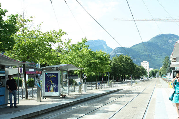
En juin dernier, lors de notre première visite, nous avons pu mieux comprendre les enjeux du territoire et observer de près la vie urbaine.
Notre objectif actuel est d´étudier en profondeur le projet, pour comprendre à quel point il est complexe et pour nous rendre compte des challenges qui nous attendent.
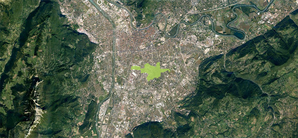
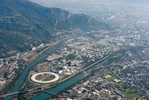
La zone de la ZAC dans Grenoble
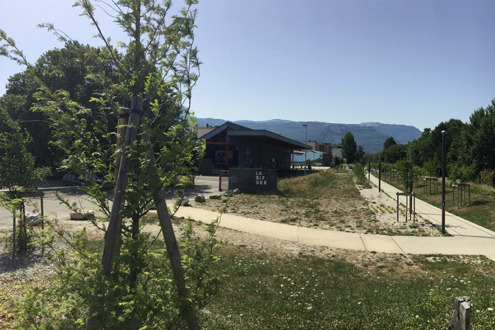
Un des moments fort de cette visite fût la découverte de la “Bifurk“ et de son “éco-système”, c’est un espace hybride où la vie bat son plein grâce à l’équipe et à de nombreuses associations très actives, qui ont su transformer cet ancien entrepôt industriel en un espace polymorphe où l´on peut trouver une grande diversité d’activités : théâtre, concerts, expositions et même un skatepark. Juste à côté, “La Plage” est la première plage urbaine permanente construite en France. Dédiée à la pratique de sport de sable elle offre au Grenoblois un large choix de sports des plus conventionnels aux plus insolites.
En face de ces lieux emblématiques de la ZAC, il est question d’implanter la casa “Terra Nostra”, une maison en terre et bois construite par les étudiants des écoles d’architecture de Lyon et Grenoble. C’est une occasion de connecter au projet une infrastructure existante, en créant une espace dédié à l´urbanisation de Flaubert à l´intérieur de la maison.
Le prototype Terra Nostra
La force de Grenoble est son ouverture d’esprit avant-gardiste : innovante et créative, elle s’inscrit depuis deux décennies dans un programme promouvant une ville plus agréable, plus sociale, plus durable. À l’écoute de ses citoyens et à l’affût des innovations techniques, technologiques, sociales et économique, Grenoble est bien plus que la 11 ème métropole française. Elle est un exemple novateur d’une volonté politique et citoyenne visant à construire autrement la ville de demain. Plusieurs initiatives urbaines et citoyennes singulières ont profondément participé à la mutation de la ville et à sa nouvelle morphologie. Le changement passe par de “grandes actions” mais aussi par de “petites initiatives” qui accumulées donne à la ville une identité propre. La ville soutient chaque année plus de 600 actions qui se regroupent autour de trois grandes lignes directrices : favoriser la participation des habitants, lutter contre toute forme d’inégalités sociales, mettre en avant des territoires les plus fragilisés.
La forte volonté de faire participer les citoyens au renouvellement de Flaubert se place dans la continuité d’une politique ouverte aux propositions de chacun et à l’écoute de ses citoyens. L´intégration de chaque partie prenante au projet permet de recentrer la ville sur ses usagers, de se focaliser sur la ville “à taille humaine”, faite avant tout pour ses habitants. Ce nouveau regard sur la ville et la re-qualification du cadre de vie qu’il engendre participe fortement à l’attractivité territoriale de Grenoble, souvent surnommée la “Capitale des Alpes”. Grenoble est un véritable laboratoire urbain : en 2005, le conseil a adopté un programme de rénovation urbaine soutenant les opérations de renouvellement urbains au sein de la ville en leur accordant un budget très conséquent. Illustrons cette singularité :
Une ville qui réinvente son architecture
La construction d’un des premiers éco-quartiers français dans l’ancienne caserne militaire de Bonne en plein centre ville ( 5 hectares) est un exemple qui concrétise le désir de concilier ville et environnement. Loisos Sava, architecte en chef du projet prône la réinvention de la façon de construire, offrant à la fois une baisse des dépenses énergétiques, une mixité sociale et une mixité fonctionnelle. Cet éco-quartier de nombreuses fois primé a notamment reçu en 2009 le Grand prix national “Ecoquartier” délivré par le ministère de l’Ecologie, de l’Energie, du Développement durable et de la Mer. De plus, très récemment une vaste opération de révision du Plan Local d’Urbanisme intercommunal (PLUi) en 2015 a été opéré. Une des mesures phares de cette révision est la diminution de la hauteur maximale de construction.
Une ville accessible et durable
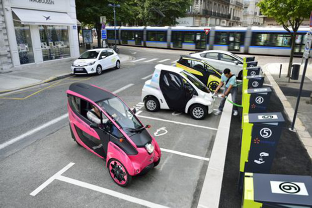
Grenoble est également une ville pour tous, mettant au centre de ses préocupations l’accueil de tous les publics. En effet elle a été classée première ville de France sur le baromètre de l’accessibilité aux handicaps avec une moyenne de 18,7 et deuxième ville européenne. Grenoble a créé un service d’auto-partage de véhicules électriques appelé “CitéLib” en collaboration avec Toyota qui souhaitait tester ici-même ce système de location unique au monde. Le but est de stimuler la multi-modalité de la ville, en effet ces véhicules 100% électriques servent à incrémenter l’offre de transports publics existants en proposant une solution alternative pour les “premiers et derniers kilomètres”.
Une ville qui s’engage
De plus, Grenoble a su marquer les esprits par une prise de position très forte en 2015. En effet, c’est la première ville européenne à bannir les publicités de ses rues, proposition qui a été soutenu par leur nouveau maire écologiste. La lutte contre la “pollution visuelle” prive la ville d’une manne de revenus importante. Des affichages dédiés aux activités culturelles et aux informations de la mairie remplacent les affichages actuels. De nombreuses autres villes voient en Grenoble un modèle à suivre.
Une ville innovante
Que ce soit au niveau national, européen ou international, Grenoble se démarque par son goût pour l’innovation. En effet Grenoble a reçu de nombreux prix et certifications à toutes les échelles:
National
En 2014, Grenoble a été labellisée “FrenchTech” ainsi que huit autres villes de l’hexagone. Ce label a pour but de donner une meilleure visibilité à l’international de l’attractivité technologique des villes françaises.
Européen
Grenoble a été, en 2014, sacrée deuxième ville la plus innovante d’Europe après Barcelone au concours pour le prix de la première capitale européenne de l’innovation. Ce prix vise à récompenser la ville qui offre le meilleur «écosystème d’innovation» en connectant les citoyens, les organismes publics, les établissements d’enseignement et les entreprises.
Mondial
Cette «iCapitale» a également été cité parmi les 15 villes les plus innovantes par le magazine Forbes en 2013.
Le quartier de la Presqu’île, au Nord de la ville est spécialisé dans les technologies de pointe. Cette Silicon Valley grenobloise est un véritable pôle d’attraction pour le reste de la ville et participe considérablement à sa renommée. La connexion du quartier de la presqu’île à la ZAC Flaubert constituerait une formidable opportunité pour le quartier objet de notre projet qui pourrait donc créer en son sein de nouvelles dynamiques. Ce n’est qu’une des propositions parmi tant d’autres, aucune piste n’est écartée, l’idée étant de procéder par étapes et de se donner un temps d’expérimentation afin d’envisager plusieurs hypothèses éventuelles.
Grenoble Presqu’île – image: www.grenoble.fr
Pour conclure, autant dire qu’en de nombreux points Grenoble sait se renouveler et imposer une nouvelle façon de penser la ville. Ces exemples inspirants et stimulants placent la barre très haut, le défi est grand et nous sommes honorés d’avoir l’opportunité de participer à l’élaboration de ce laboratoire urbain qu’est la ville de Grenoble.
À bientôt pour plus de nouvelles sur ce projet !
April 26, 2016
Last November we were selected, in collaboration with Transform.city, to participate in the Neue Copa Cagrana International shortlisted competition in Vienna (Austria). The scope of the competition was the urban revitalization and definition of the Master Plan in the area Neue Copa Cagrana defining an urban proposal and the relationship of this part of the city with the river.
We were selected along with other 8 teams, including renowned firms such as Dominique Perrault, AZPML, or West 8.
The study area is located next to Donau City, on the left bank of the new Danube Canal, Neue Donau, passing through the city of Vienna. It is a neighborhood of mainly tertiary character with office buildings of great height, developed in the last 20 years, including the Vienna International Centre.
Copa Cagrana – the intervention area, between the Danube and the new urban area with the D. Perrault’s tower
Despite the good connection with the city center, the large number of buildings and the excellent existing natural qualities, the area is almost deserted during day and night. This is mainly due to the lack of variety of uses, commercial facilities and recreational areas.
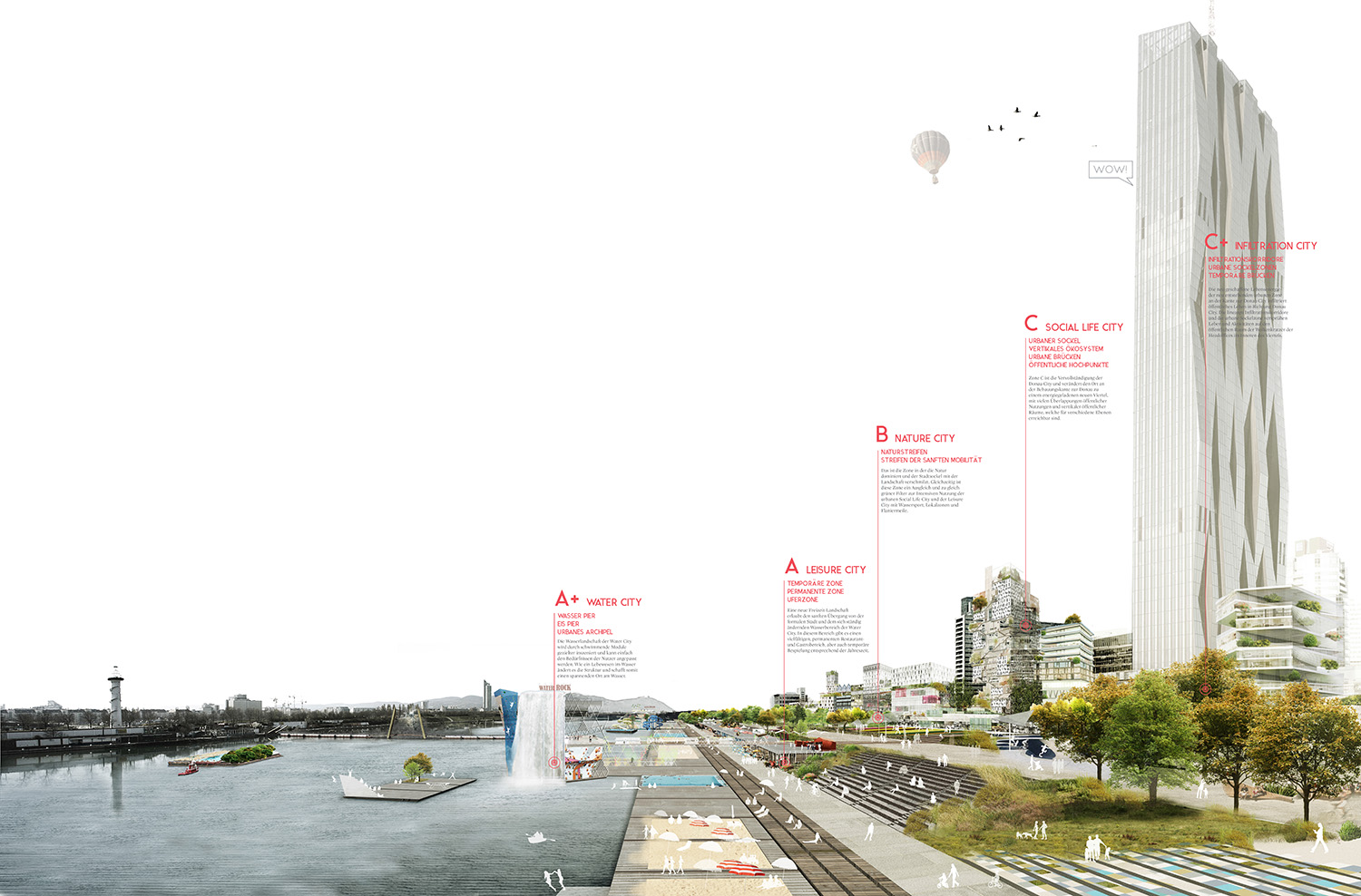
The proposal develops a series of strategies to revitalize an area that already has the optimal conditions to become a landmark for the city of Vienna:
The proposal aims to incorporate urban, commercial and leisure life at a time when Vienna is starting to look for other forms of identity for the river area. It is important to bring new residents to help to create urban activity throughout day and night, summer and winter seasons by permanent and temporary uses. The mixed-use and residential functions in the first row, including the urban boulevard, have the potential to complete and complement the existing urban fabric and establish, for the first time, the necessary connections to make Donau City a functioning and exciting neighbourhood.

Activity diagram for the different seasons
The project proposes a high density urban prosthesis, combining housing, office, commercial and public space, in order to create an active urban spot connected to the surrounding, improving its identity and multiplying the possibilities of use.
The proposal seeks to make Donau City easier to be understood and perceived, with a clear connection to Danube river and its waterfront. Therefore, the proposal is the missing link to the completion of the Donaustadt and is, at the same time, the necessary catalyst to enable the urban regeneration in the area.
Copa Cagrana will be an exciting new urban spot in Wien, which is perfectly connected to the city network thanks to the transport connectivity and subway line. Through the physical proximity with existing Donau City, Donau Insel and surrounding neighborhoods, the area will increase popularity and will offer more attractions to the users.
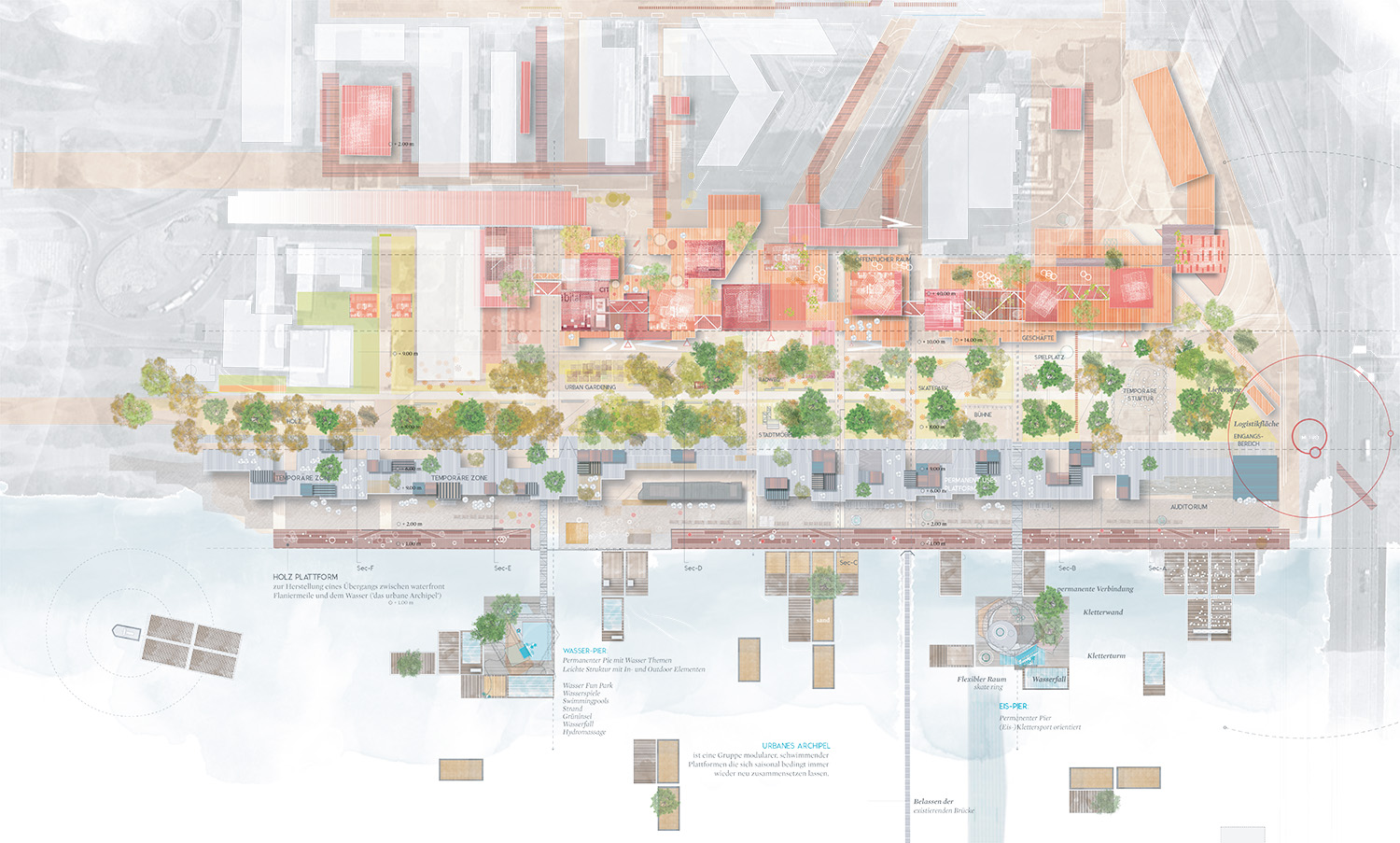
The newly created waterfront will be an urban catalyser with a variety of urban functions, with uses according to the seasons and day and night time:
The FILTER ZONE is a more quiet area free of commercial activities.
The TEMPORARY ZONE changes according the different seasons, with beach bars in the summer, pop-up restaurants, terraces and platforms, etc.
The WATERFRONT is an enjoyable walkable strip with piers and exciting water activities for summer and winter.

The FILTER ZONE
A new urban and natural environment intrinsically connected with surrounding nature.
It will be the connecting environment between Donauinsel and Donau Park but also extending its limits over the water landscape of Neue Donau to create a vibrant and diverse waterscape.
Masterplan 1:1000
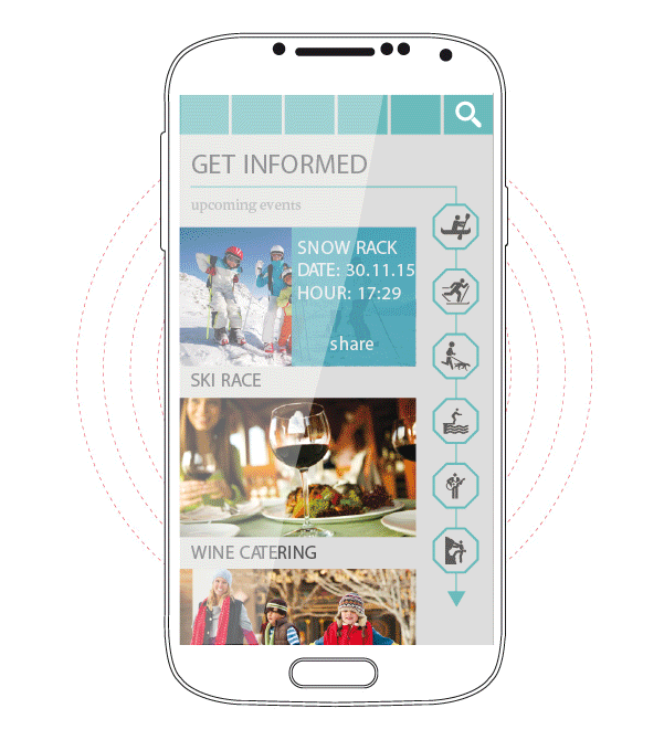
It is important to create the communication channels in order to advertise and share information about the ongoing activities and as a way to share potential ideas to be implemented. This web APP is thought to work as a social network that provides information for the citizens of Copa Cagrana on what kind of activities they can do on this renewed urban area.
Users will be able to register and create a user profile, with this, they will have the opportunity of proposing activities that will make use of the beautiful surroundings and installations of this urban space. The commercial sector will also have their own space. They will have the possibility of creating a profile which will allow them to publicize their products and business, as well as invite and inform citizens about special deals, offers, events and other celebrations.
Cross Section
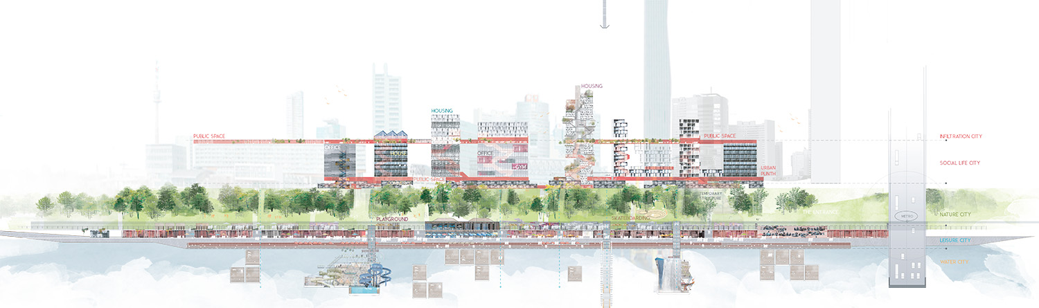
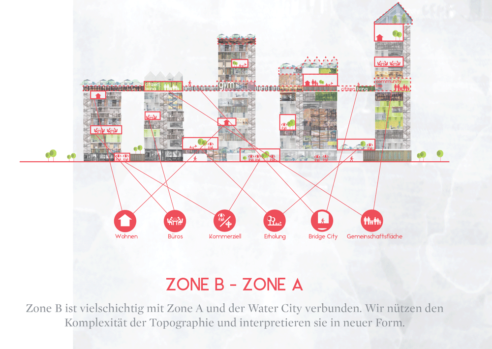
Seeking to achieve these four objectives, the proposal creates 5 zones acting together and related to each other:
The energy of city life will splash towards Donau City and the urban plinth will extend its limits to bring activity and reconfigure the public spaces around the corporative and residential buildings. These urban tentacles will extend urban plinth limits with linear and small scale pavilions, pop-up stores and cafes, etc. reconnecting and renewing the pedestrian pathways of the Donau city.
Elevation
Zone C proposal is the most powerful urban energy boost, as it provides a large amount of overlapped new programs and public spaces easily accessible at different levels.
Areas:
Urban plinth: fragmented construction from 1 to 4 stories high, multiple programs with predominance of commercial spaces overlapped with public spaces at different levels.
Vertical ecosystems: housing towers with a myriad of different typologies to create a diverse neighbourhood. The housing units help to create a dense neighbourhood with urban life throughout the day.
Urban bridge: On the tenth floor, same level as the top terrace of the existing linear building of social housing, a bridge is creating connections between semi public spaces, with diverse programs within the vertical ecosystems.
Public peaks: the top floor of the different towers is also part of the network of semi public spaces within the vertical ecosystems. These spaces can hold multiple programs and part of their success will be the privileged point of view of the city (terraces, cafes, common spaces,… )
This is a zone where nature is predominant and the urban plinth is melting its limits with the landscape. At the same time, the natural character of this area helps to make the transition between the bigger, urban scale of zone C and both the lower scale of zone B and the waterscape towards Donauinsel, combining natural areas with paths for soft mobility.
Different cross sections in zones A and B
Leisure cityscape to allow the transition between the formal city and the vibrant and ever changing new waterscape of zone C+. It will hold multiple permanent uses but also temporary programs and seasonal activities. There are multiple temporary and permanent uses in small buildings with similar language, as well as a new riverside walk that will extend to create a comfortable linear space. The relationship with water and the elevation difference will be resolved with a wooden platform that will act as an urban sofa to relax and enjoy the presence and proximity of the river.
Vibrant and ever changing waterscape in continuous evolution. It will extend the activities of the new urban spot towards the water.
Masterplan 1:2000
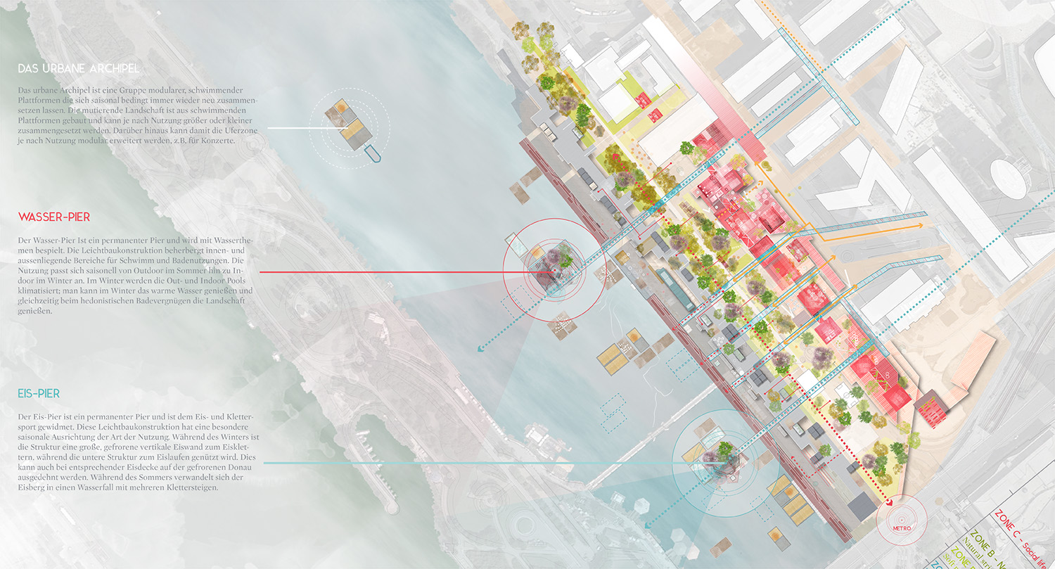
+ water pier: permanent pier, water thematic. Light structure with indoor and outdoor spaces to allow the creation of different bathing experiences. The use will change seasonally, during the winter, outdoor and indoor climatized pools will allow the user to be in connection with the surrounding natural landscape while having a pleasant bathing experience.
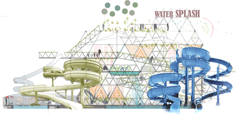
The water pier for summer activities
+ ice pier: permanent pier, ice and climbing sports oriented. Light structure with a strong seasonal connection. During the winter, part of the structure will be a huge frozen and faceted vertical surface to practice ice climbing, while the lower platform will host different ice skating outdoor rinks to practice in connection with the water and natural landscape. During the summer the ice surface is transformed into a huge waterfall falling from the upper level into the river.
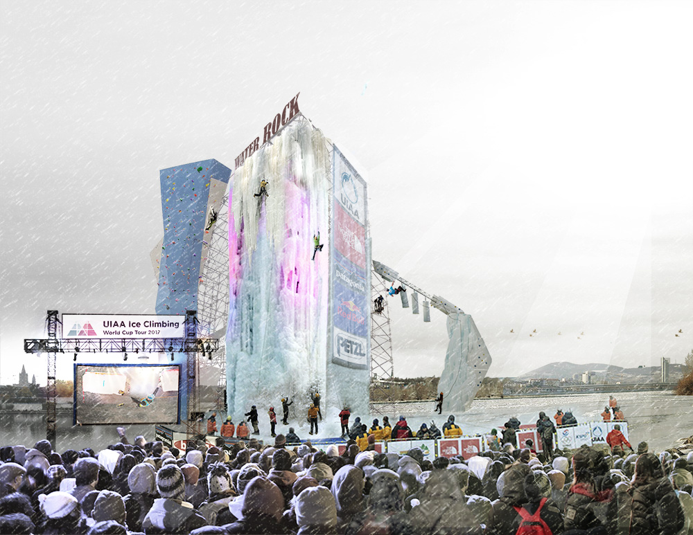
The ice pier for winter climbing
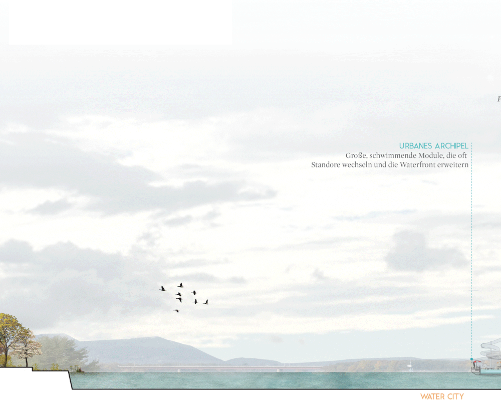
+The urban archipelago: big modular and floating ever changing extension of the waterfront. The different seasons and uses will dramatically transform its configuration. This mutant landscape is built with modular floating platforms/barges that can be combined to create larger flat surfaces if necessary. These platforms can be connected to the limit line of the waterfront to extend its surface.
If you want to know more about the proposals you can download the competition panels here:
Panel 1 Panel 2 Panel 3 Panel 4
November 13, 2015
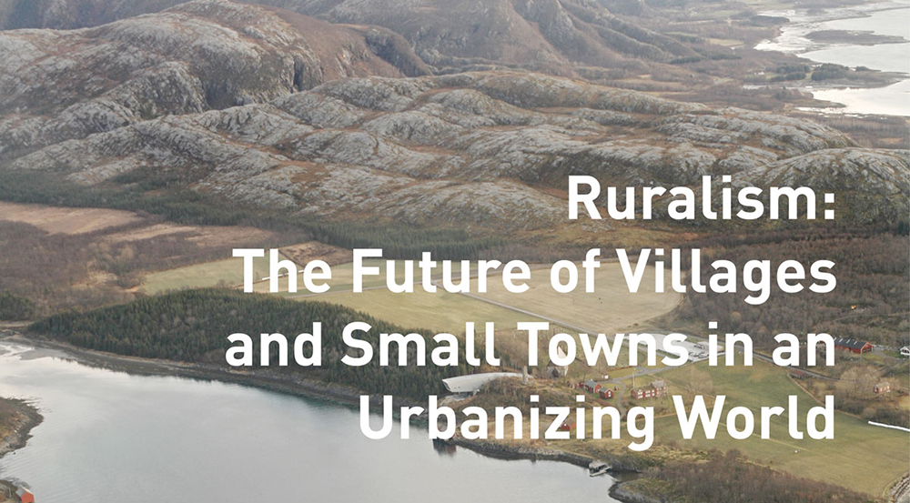
Next November 18th, Belinda Tato will be keynote speaker at the International Conference, ISU Talks #03: Ruralism organised by the Institute for Sustainable Urbanism. Other speakers include Snøhetta, OMA/AMO, etc…
The institute is located in Braunschweig, Germany and according to their own definition is part think-tank, part design laboratory, committed to promoting research and scholarship on sustainable urbanism in an international and interdisciplinary setting.
Since October 2012, ISU is lead by Prof. Dr. Vanessa Miriam Carlow, within TU Braunschweig’s Department of Architecture, Engineering, and Environmental Sciences. ISU has worked with partners in Africa, Asia, South America, USA, and all over Europe. ISU has four themes under which its teaching and research projects fall: Space as Resource, City in Society, Impossible Sites, and Urban-Rural Relations.
Here is a brief introduction to the Conference:
In the current city-centred discourse, rural spaces are often dismissed as declining or stagnating. However, rural spaces also play a critical role in sustainable development, as an inextricably linked counterpart and complement to the growing city, as extraction sites, natural reservoirs, providing for ecosystem services or leisure spaces.
The city and the countryside are evermore increasingly mutually reliant. A closer look at the countryside unveils a set of dynamics overlaying and changing rural space, beyond trends of depopulation and shutdown of public facilities. The once remote and quiet countryside is now traversed by global and regional flows of people, goods, waste, energy and information, interrelating it with the larger urban system, even bringing it to the frontlines of regional transformation and sustainability.
The conference proposes the following questions:
– How can the contemporary rural be conceived of and described?
– What new concepts for rural living currently exist?
– How are urbanisation and ruralisation processes connected?
– Can impulses for the design of urban space be drawn from the imagined and practiced connections between the urban and the rural?
– How can we formulate a (new) vision for ‘ruralism’?
May 21, 2014
Concept drawing of the piers as landmarks
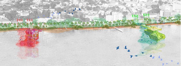
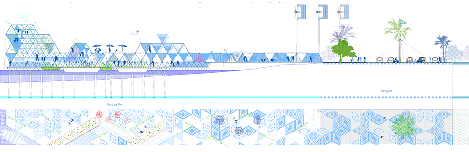
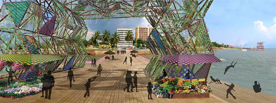
Ecosistema Urbano was recently selected as one of the five finalists in a competition of ideas for the waterfront (Bord de Mer) of Libreville, capital city of Gabon. We were selected by the committee of the Agence Nationale de Grand Travaux du Gabon among many other proposals. In their own words, the proposal “has strong linkages to existing urban systems, improves coastline’s connections and celebrates Libreville culture and history.” Here is a brief descripton of the project:
The main goal of our proposal is to reunite Libreville with the seashore, and extend the life of the city to the waterfront in some specific points. This would be achieved through operations of urban regeneration, adjusted to the existing and to the specific cultural, sociological and economical context. The proposal concentrates visual impact, identity and activity in five nodes, instead of spreading them too thin along the promenade.
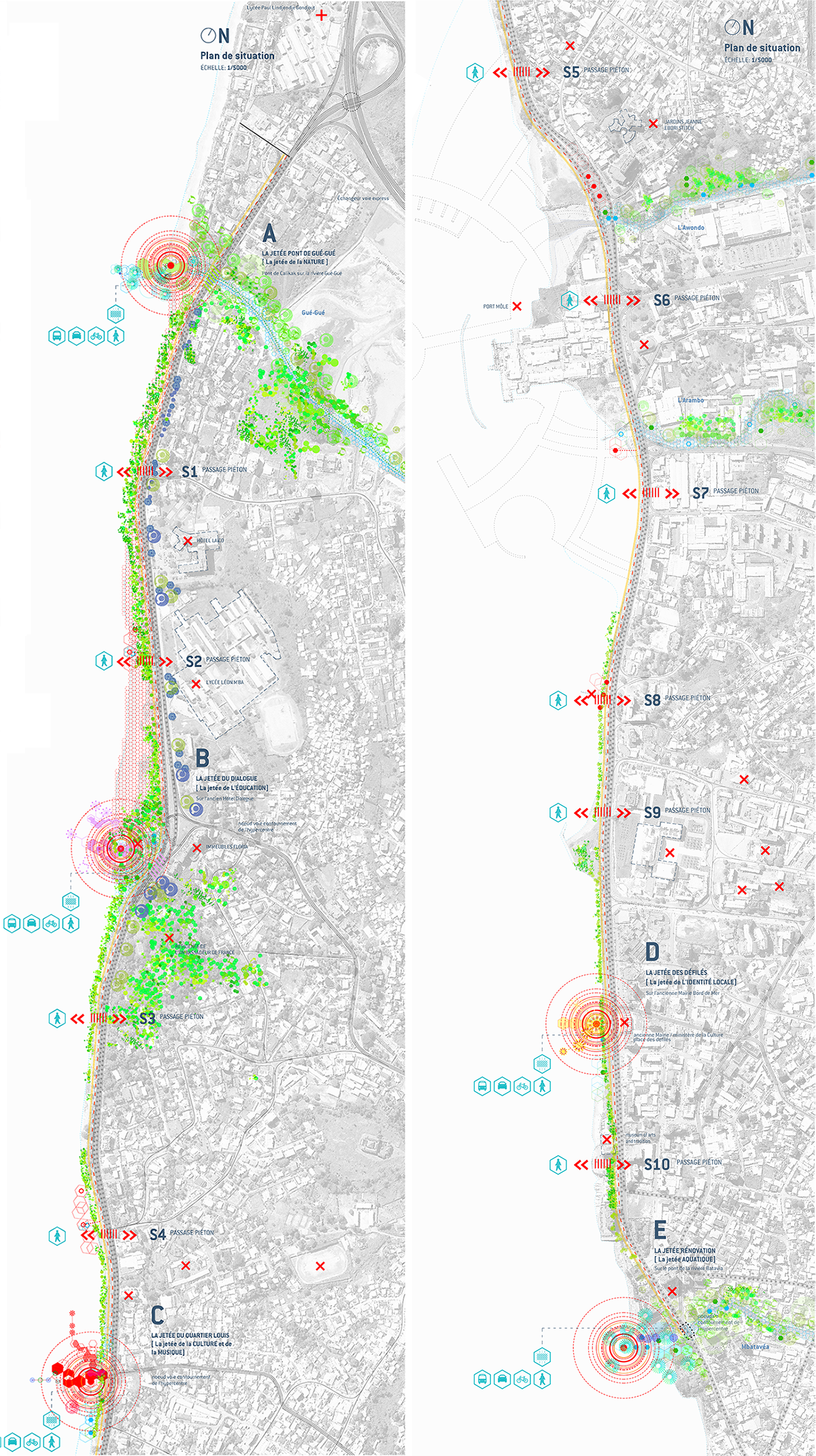
Plan of the coastal line of Libreville, in two sections
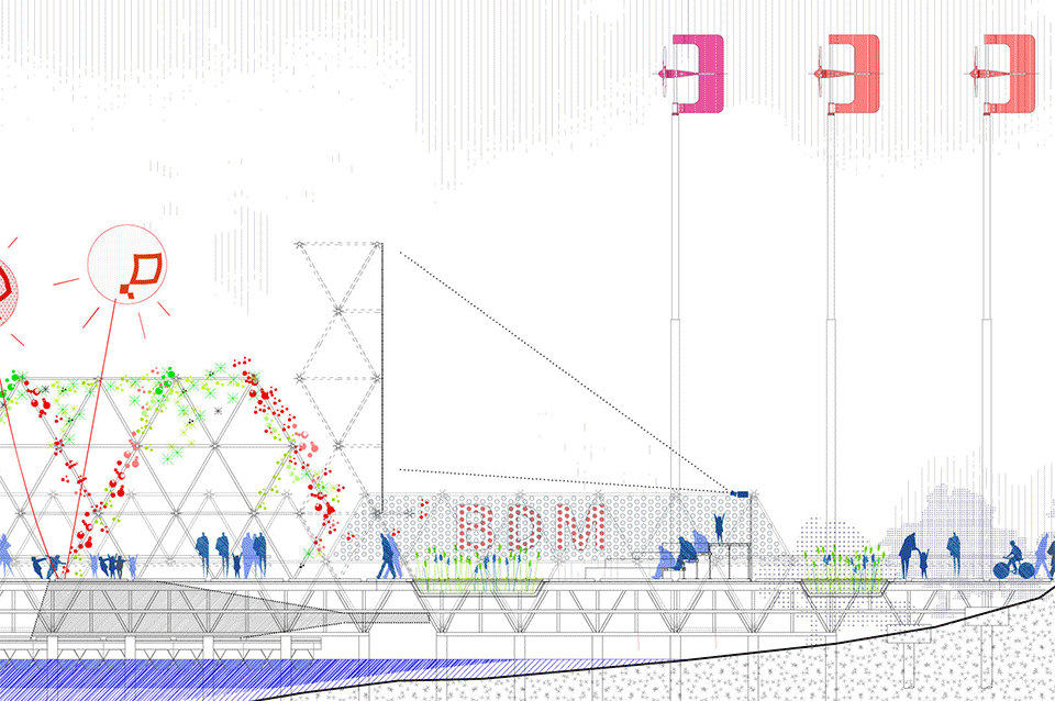
Those five pier-like structures (jetées) are a great way of getting closer to the water, of having a unique view of the city and at the same time of providing space for programs that could work as catalysers of the urban life. They act as unique landmarks, breaking the regularity of the very long promenade and facilitating the orientation of citizens. These points of “urban acupuncture” would drag attention and pull the urban life of Libreville to the seashore, providing a new space for citizens to interact.
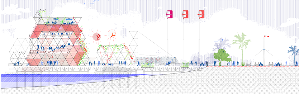
Section of the biggest ‘jetée’
Section of one of a longer and lower pier structure
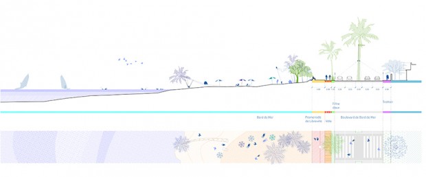
Section through a beach area, where the promenade is reduced to the minimum
The locations and uses of the piers are defined in relation to the city: to its flows, to the activity of the closest neighbourhoods and to the most relevant uses, buildings or public spaces nearby. Following that close relation with the surroundings, each pier has a singular character defined by the size, the shape, the vegetation, the dominant colors and other design factors, but also by the specific set of activities that can be performed in them. This way, we have the pier of Nature, Education, Culture and Music, Local Identity and Water.
The use of the structures would change along the day
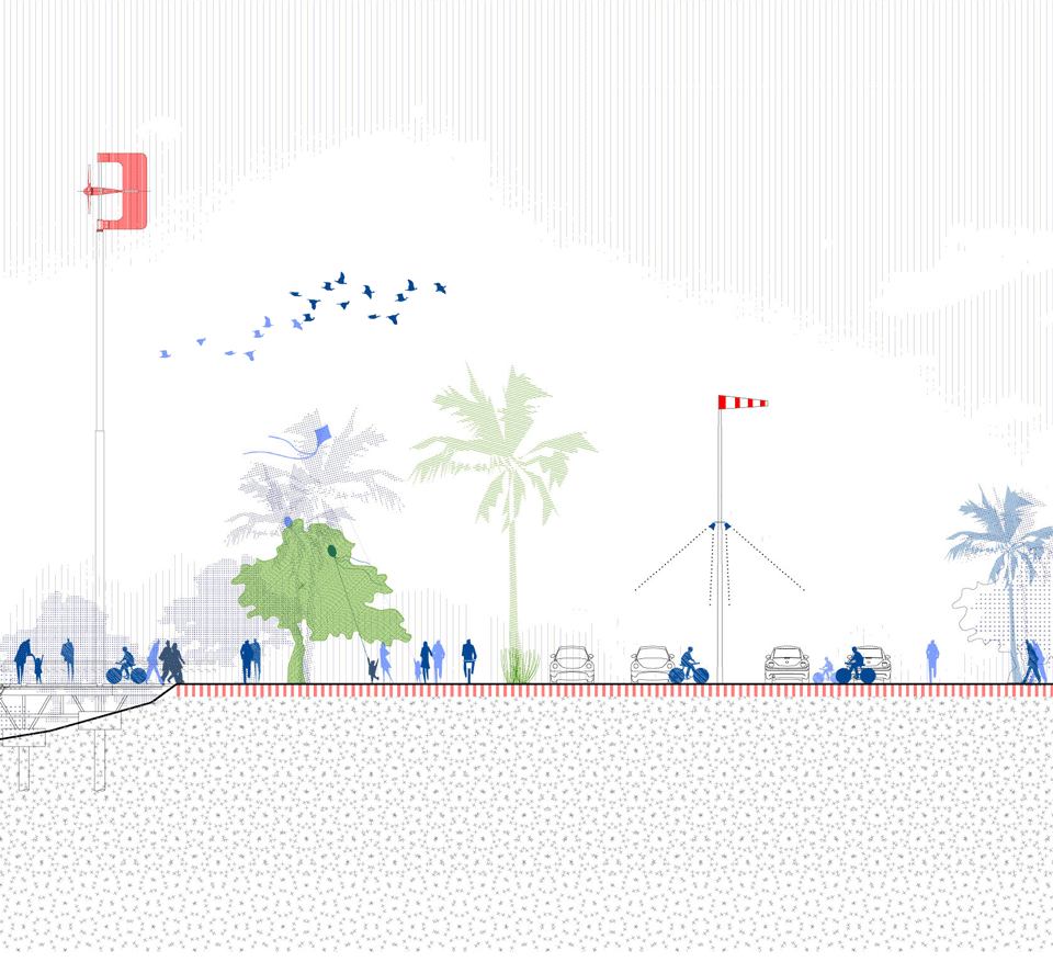
On the other hand, the linear promenade itself changes the configuration of its section depending, again, on the surroundings. Some key elements are defined in that section: the waterfront boulevard for (unavoidable) motorized traffic, a series of landscape markers (associated with energy production and visibilization), a coastal bike lane, a waterfront promenade, an urban appropriable fringe… This elements are combined, stretched or shrinked, generating diverse profiles and multiple areas of interest.
The crossings in front of the piers would be shared areas for pedestrian and motorists
Thus, while the promenade is kept simple, regular and clean, these structures act as landmarks, dividing the seafront in more aprehensible, walkable sections, and marking the coast like ‘signal fires’ or lighthouses: they provide visual clues to help the passer-by understand his exact location at a glance.
View from one of the piers
In addition, based on the rapidly rising mobile market penetration in Gabon, and as a bet on the potential of hyperlocalized digital networks for urban life, the proposal includes a digital application that would work as a geolocated and participatory cultural agenda for the waterfront, showcasing the activities along the line, attracting citizens and visitors, allowing them to search and follow events, and acting as a geographic map or guide.
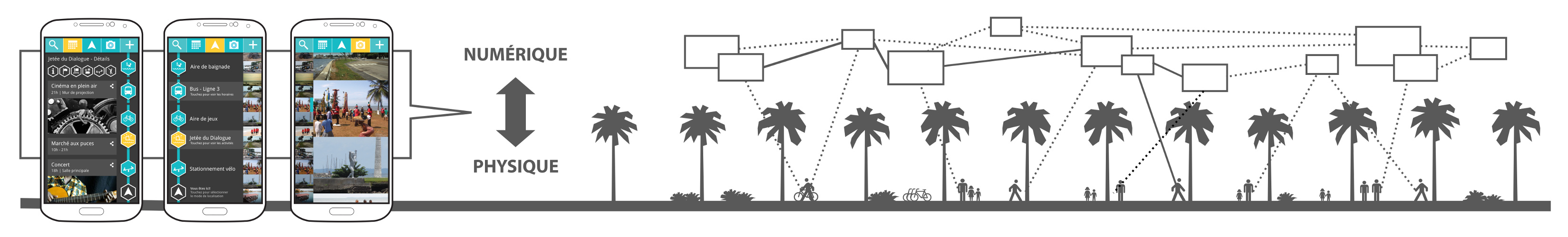
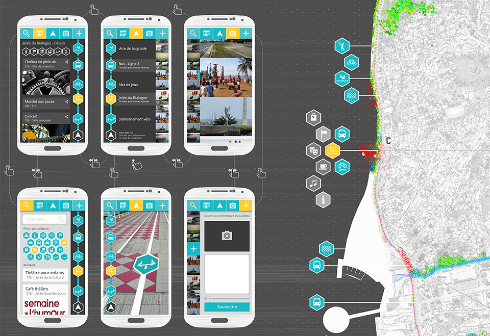
Tentative mockup for the application, based on the previous proposal for ‘BikeLine’
This proposal was developed in collaboration with the landscape architecture office Uberland.
September 3, 2013
Pablo de Soto is part of the generation who lived and experimented with the creative explosion generated by the web. His studies in architecture have enabled him to look at digital culture through a unique perspective. Keeping as reference, science fiction, situationism, and hacker ethic.
In 2001, he founded hackitectura.net, along with José Pérez de Lama and Sergio Moreno Páez, and a crew of architects, programmers, artists, and activists that participated in projects that dealt with themes of cartography and mapping. I interviewed Pablo de Soto about Sevilla Global, Cartografía Crítica del Estrecho de Gibraltar, and Mapping the Commons (Istanbul and Athens)
Here are a few screenshots of the maps:
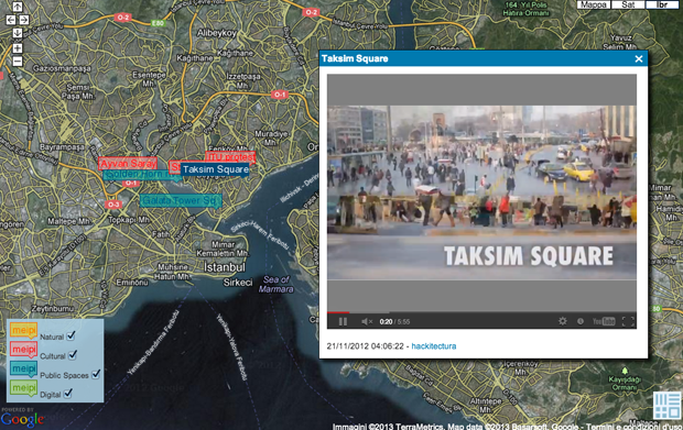
Taksim Square, Istanbul
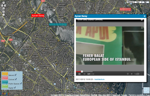
Fener Balat, Istanbul
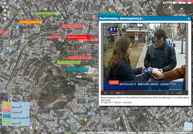
Brook Crossing, Athens
This post is part of the MetaMap series about mapping. You can follow the conversation on your favourite social network through the #metamap hashtag.
July 28, 2013
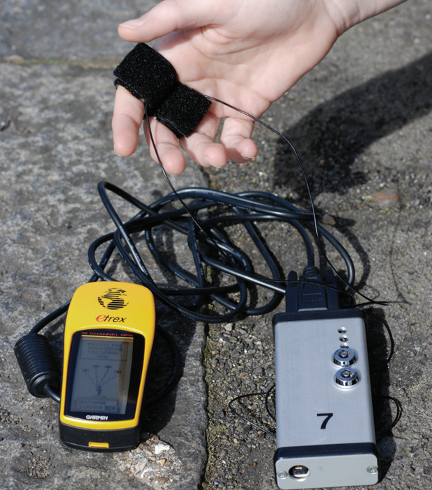
Biomapping device and GPS
Today, I present the interview with Christian Nold where he shares his experience with mapping projects such as Bio Mapping, Greenwich Emotion Map, and SanFrancisco. He describes himself with the following:
Christian Nold is an artist, designer, and educator working to develop new participatory models for communal representation. In 2001, he wrote the well received book ‘Mobile Vulgus’, which examined the history of the political crowd and which set the tone for his research into participatory mapping. Since graduating from the Royal College of Art in 2004, Christian has led a number of large scale participatory projects and worked with teams on diverse academic research projects. In particular, his ‘Bio Mapping’ project has received large amounts of international publicity and has been staged in 16 different countries and over 1500 people have taken part in his workshops and exhibitions.
In 2007, Christian Nold founded Softhook Design, which is now providing large scale public discussion projects, such as the TownToolkit. Christian Nold teaches at the Bartlett University, College of London and is a guest lecturer at Aalborg University of Denmark and an active member of the Council for the Internet of Things.
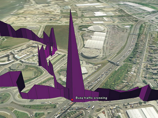
Galvanic Skin Response in a busy traffic crossing
1. How did you get to the practice of mapping?
Mapping for me is a way to understand shared places. I entered this area through psychogeography and the idea that there might be shared psychological and unseen, but political structures that underlie the physical environment around us. Mapping then becomes a way of trying to record this kind of exploration. The shared mental and physical spaces, which are shaped into the form of a map, are such a familiar way of recording spaces that we can all access.
2. In what way do you obtain and treat the data for your mapping?
I utilize different types of mapping in my work, but my main interest is trying to articulate the blend of space between mind and material. The sources of my data tend to be ambiguous, such as physiological arousal, smells, sounds, feelings of being in or out of control, or illicit behavior. My real interest is trying to map things that are difficult to map, or for political reasons, are not being mapped at all.
3. What is the application of open source mapping you are interested in the most?
What interests me about open source mapping is the way it provides agency for people to redefine how things are done. The openness allows people to redefine mapping in terms of what is being mapped, as well as how to do the mapping.
Greenwich emotion map
4. What is the next phase of development your research is undergoing?
I’m currently researching whether mapping is a device ethnography at the Extreme Citizen Science Group at UCL. This means I’m trying to trace networks of knowledge and power being generated by sensing devices and trying to map and articulate what is going on there. The final results will not be maps, but will utilize the methodology and thinking of mapping to uncover the relationships between entities, which I think is the core of what mapping is truly about.
5. What are you personal references for the theme of mapping (from ancient to contemporary ones)?
I love some of the pre-modern maps that blend stories and myths, as well as local plants, flowers, and animals that simultaneously describe the physical environment. Many of those maps show a freedom of blending together and crossing between categories that you don’t see any more in modern maps. Nowadays, maps seem to focus more on what they exclude rather than focusing on what they represent.
San Francisco emotion map
You can see related posts in the metamap series.
July 23, 2013
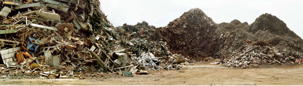
Basurama is a forum for discussion and reflection on trash, waste, and reuse in all its formats and possible meanings. It was born in the Madrid School of Architecture (ETSAM) in 2001, and since then, has evolved and acquired new shapes.
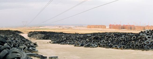
Tire Cemetery in Seseña (Toledo)
I interviewed Pablo Rey Mazón, member of Basurama, about 6000km, a project about the concept of trash applied to new constructions and land use, the metabolism of the city.
1. How did you get to the practice of mapping? What led you to the practice of mapping?
We use mapping, a geo-spatial representation of things, to understand and display complex situations. Maps have always been interesting to me: subway maps, the Callejero (the streetmap book from Madrid), and later in architecture school, I was using and producing maps quite often. Google Maps and Google Earth came later…. maps are one special part of all the data visualizations tools available.
I have also participated in the development of meipi.org, an open source software for collective geo-location of information (texts, photos, videos, and audio) online, that we have used in many projects.

Interface of the map – Click to see original at Meipi
2. How did you choose the object of your mapping?
A map is a tool to decode certain information. Depending on the project, we would use one visualization or another. When we’re interested in the location of things, we use maps. In Basurama, we’ve used maps for many different projects apart from 6000km:
-Mapping urban metabolism landscapes (panorama photos) + real estate bubble: map, tactics in 6000km
-Mapping reusable waste in Ruhr (Germany) map 1, map 2: how to
In Ruhr, we used geo-located photos that we took, and a special instance of Meipi, to show the location of possible reusable waste. In spermola.org, we tried to give the opportunity to exchange an object by providing information about where the object was.
6000km started as an exhibition of 10 big format panorama photos from the Madrid outskirts: landfills, highways, scrapyards, and abandoned places. The project was part of the exhibition and was named Basurama Panorámica. It shows the public different places to envision the consequences of the urban expansion that was occurring at the time. Each photo had a short text attached to it, that served to contextualize and give basic information about it. We didn’t just want ‘awesome’ photos, we wanted to make people understand where and what those locations were. The exhibition had two related maps: urban growth and highways, apart from a location map of all the photographs. Displaying urban developments together with landfills and empty toll highways was the way to show the relation among all the urban metabolism related situations. Empty buildings made for speculation purposes where as waste made for scrapyards. That was 2006, 2 years before Lehman Brothers declared bankruptcy.
Later on, when we addressed this project in a country scale we studied and mapped all the situations in 6000km.org. “6.000 km” were the kilometers of highway that the government was planning to build until 2020.
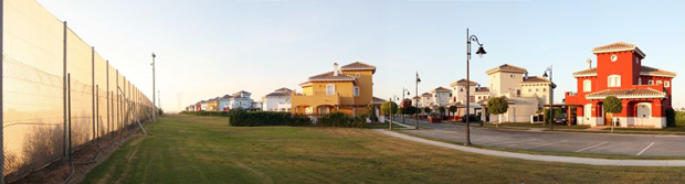
Mar Menor Golf Resort – Torre Pacheco, Murcia
3. In which way do you want this work to affect the people and society?
It is difficult to say how a particular project modifies the perception of a situation. In 2006 the real estate bubble was about to burst, but the public perception was saying “prices are never going to drop”, “we are the biggest growing economy in the world”, “keep building, buying, and selling, make money”. Mass media and politicians were basically denying the real estate bubble or saying that the process of land destruction was not sustainable. It was uncommon to address this topic. Nowadays, we can watch and read multiple news, documentaries, and exhibitions about a contemporary ruin or the economic crisis, but that was not the case back in 2006. It is impossible to measure that impact.
However, we were not alone in this task. There were other people talking about these issues as well. An example, El tsunami urbanizador español y mundial from the late Ramón Fernández Durán, or Ramón López de Lucio, that used our exhibition, among other things, to talk about the urban expansion and the backdrops of the star system architecture. A year later, the Observatorio Metropolitano published a complete study of Madrid that delved deeply in the economical, social, and urban aspect of the situation. Madrid ¿La suma de todos? Globalización, territorio, desigualdad, and Derivart published casastristes.org.
Junkyard Hermanos Lopez – Parla, Madrid
4. Which is the next phase of growth/development your research is undergoing?
We went from the regional scale, Madrid conurbation, to a country scale, Spain, in 6.000km. We created an online map at meipi.org/6000km to display how our research evolved and to open both the information and participation to the public. We went to many of those places to document the sites. We have a full list available of all the studied locations, as we have realized before in Meipi, that maps are not the only way to show spatial information, and that lists can also be very useful.
Global scale: Since we’ve been travelling often to America with Basurama in the last years, we are now exploring ways to talk about these situations on a global scale in PAN AM, Panorama Americana.
Ruins in Vallecas, Madrid – Click to view original map
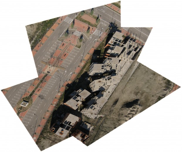
Photos from the sky: We are also exploring new ways of exploring the territory with cheap balloon mapping technology. Our first results from Spain could be seen in the ruins at PAU del ensanche de Vallecas. Since last year we’ve been collaborating with the Public Laboratory in Boston, where we are mapping the evolution of an ash landfill in the suburbs of the city, Incinerator Landfill in Saugus, MA, USA, as well as mapping the waste locations from Cambridge, MA.
Civic maps: I am involved in a tool kit about civic mapping that will be released this year by the Center for Civic Media.
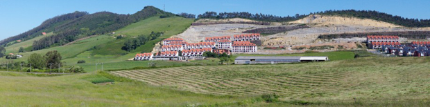
Alto del Cuco – Pielagos, Cantabria
5. What are your personal references for the theme of mapping (from ancient to contemporary ones)?
References come from many places: data visualization researchers like Edward Tufte; open hardware and cheap tools by Public Laboratory; Ushahidi and Crowdmap for collective info about maps; vojo.co for collective reporting from cheap phones; and online cartography tools like OpenStreetMap, where we are contributors and try to draw landfills and other non represented places in the map.
All the photos of the article are under a Creative Commons Attribution 3.0 Unported License and are made by Rubén Lorenzo Montero and Pablo Rey Mazón (Basurama). See legal notice.
July 19, 2013
Marielyst is a small town in the south of Denmark well known for being one of the most popular holiday locations on the Baltic Sea. Since the beginning of XX century its 20 km of white sand beaches attracted an increasing number of seasonal tourists, up to host nowadays 6000 summer houses in its area. The spatial configuration of Marielyst appears chaotic and it’s lacking of a recognisable identity; the main element of the urban structure is the principal street, a traffic vein that allows people to reach the heart of the small town, and from which secondary narrow streets start connecting every single wooden house. The subject of Marielyst competition was finding and providing a spatial organization to this place in order to structure an urban articulation among its parts. Moreover, an important feature to be considered in this site’s revitalization was the “beachy” atmosphere of Marielyst, its main character.
As usual, we worked with a multidisciplinary and international team, with the Danish landscape Office Kristine Jensen, after being chosen among 4 other finalists.

Plan
Our proposition started from the identification of the land’s shape, which changed its configuration many times until the present. In the past, the island of Falster -where Marielyst is located- was composed by three smaller islands and was crossed by water; the area had been also flooded and remained swampy for many years, until the late 1800, when it was drained. Inspired by this ancient situation, we conceived the idea of “Delta“, a sinuous and porous path that connects the dynamic activities of urban space with the relaxed atmosphere of a beach context.

Summer time
The landscape project focuses on the valorization of the great quality of the natural elements that characterize the site -pines, sea, sand dunes, dike, grass- making them stand out very clearly. The concept of “Delta” appears with the intention of spreading many accesses to these natural landmarks, connecting them through physical and conceptual paths. The Delta structure allows to pull the beach ambience in the urban space, both melted in a fluid unity; the achievement of this atmosphere is possible by choosing very soft and discreet materials to create paths and furniture elements, by substituting the current asphalt with tracks, marks and signs that simplify integration between the two ‘souls’ of the place.

Witer time
We elaborated one of the main aspects of Marielyst STRAND proposition, the activity plan. “Let it be fun!” is the motto we’ve chosen to summarize our idea to regenerate this area, being certain that the requalification of an urban space could not disregard the involvement of people in making the place alive.

The activity plan during daytime

Activity plan for the night
We’ve developed a series of entertaining and bizarre urban objects and we have settled them in the Marielyst area in order to provide several activities aimed to reinvigorate the site during summer as well as winter time. We have tried to get inspired by the surrounding environment to elaborate ideas that allow people to appreciate the visible and the invisible natural local elements.

Catalogue
Our proposition for Marielyst urban contest mainly consisted in designing urban objects strictly connected with natural elements that characterize the site, like rich vegetation, long beaches, fresh water and strong wind. The objective of our urban design strategy for Marielyst was to transform this ordinary beach on the Danish coast in a unique and very attractive site that could easily become a reference point for people who want to spend funny holidays in sustainable way.

Catalogue
The catalogue includes elements to enjoy the view of landscape from above (the watching tower, the balloon in the sky); elements integrated in the vegetation that allow to take advantage of its amenity in an unconventional way (the hammocks, the spider net, the hanging chairs, the fireplace); objects that transform the beach in a big playground (the playful tower, the oversized playground); objects that use wind to catch its power and transform it into energy (the windmill lamp) or just exploit its strength to create ephemeral landmarks (the wind fish, the wind parade).

Catalogue
Other elements are mobile and contribute to constantly change the configuration of the place, like the rolling cabins -temporary supports for sport activities or refreshment bars-, or the vehicles on wheels, a kind of elaborated bikes that could be used to move along the city and create temporary stages, movable slides, or on the road benches. Moreover a big attention is given to the socializing areas, as the rooftop terrace of an existing building along the main street, the picnic area or the water cloud, a playful object very useful to refresh atmosphere during sunny days of Baltic summer.

Catalogue
July 22, 2011
![]()
Per la nostra sezione #followarch #web, oggi presentiamo Paesaggio Critico.
Paesaggio Critico nasce dopo l’amara constatazione che l’architettura del paesaggio è pressochè assente nell’abito culturale italiano. Questo fatto è evidente ogni qual volta non è possibile reperire libri e pubblicazioni di paesaggio diverse dalle riviste “da guardoni” da guardare distrattamente, ci racconta Francesco Tonini, architetto del paesaggio e fondatore del blog che vi presento oggi.
Francesco assieme a Luca Dionisi e Gabriele De Sanctis, di Garage Paesaggio sono tra i primi architetti del paesaggio prodotti dall‘università di Roma, Ludovico Quaroni, ed anche tra gli ultimi. Il percorso di studi, 3+2, in progettazione dei giardini e paesaggio, che li ha resi tra i pochi italiani con i requisiti per l’iscrizione all’EFLA, tra cui appunto un percorso di studio minimo di 4 anni, si è gia dissolto nell’ennesimo ri-ordinamento degli studi. continue reading