
Desde el 1 de mayo están abiertas las inscripciones para participar en el Concurso internacional de ideas SEE / Santiago Ecologías Emergentes. El Comité Científico contará entre sus miembros con Belinda Tato y José Luis Vallejo. continue reading
May 25, 2016
Desde el 1 de mayo están abiertas las inscripciones para participar en el Concurso internacional de ideas SEE / Santiago Ecologías Emergentes. El Comité Científico contará entre sus miembros con Belinda Tato y José Luis Vallejo. continue reading
July 8, 2014
Today we introduce you to Claire Cassanet, a young landscape engineer who just left the office after four months of internship. We worked and learned together, we cooked together, we enjoyed every day in her cheerful company. We already miss you, Claire! Read on as she describes her experience with us…

Claire!
July 23, 2013
Basurama is a forum for discussion and reflection on trash, waste, and reuse in all its formats and possible meanings. It was born in the Madrid School of Architecture (ETSAM) in 2001, and since then, has evolved and acquired new shapes.
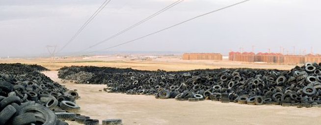
Tire Cemetery in Seseña (Toledo)
I interviewed Pablo Rey Mazón, member of Basurama, about 6000km, a project about the concept of trash applied to new constructions and land use, the metabolism of the city.
1. How did you get to the practice of mapping? What led you to the practice of mapping?
We use mapping, a geo-spatial representation of things, to understand and display complex situations. Maps have always been interesting to me: subway maps, the Callejero (the streetmap book from Madrid), and later in architecture school, I was using and producing maps quite often. Google Maps and Google Earth came later…. maps are one special part of all the data visualizations tools available.
I have also participated in the development of meipi.org, an open source software for collective geo-location of information (texts, photos, videos, and audio) online, that we have used in many projects.

Interface of the map – Click to see original at Meipi
2. How did you choose the object of your mapping?
A map is a tool to decode certain information. Depending on the project, we would use one visualization or another. When we’re interested in the location of things, we use maps. In Basurama, we’ve used maps for many different projects apart from 6000km:
-Mapping urban metabolism landscapes (panorama photos) + real estate bubble: map, tactics in 6000km
-Mapping reusable waste in Ruhr (Germany) map 1, map 2: how to
In Ruhr, we used geo-located photos that we took, and a special instance of Meipi, to show the location of possible reusable waste. In spermola.org, we tried to give the opportunity to exchange an object by providing information about where the object was.
6000km started as an exhibition of 10 big format panorama photos from the Madrid outskirts: landfills, highways, scrapyards, and abandoned places. The project was part of the exhibition and was named Basurama Panorámica. It shows the public different places to envision the consequences of the urban expansion that was occurring at the time. Each photo had a short text attached to it, that served to contextualize and give basic information about it. We didn’t just want ‘awesome’ photos, we wanted to make people understand where and what those locations were. The exhibition had two related maps: urban growth and highways, apart from a location map of all the photographs. Displaying urban developments together with landfills and empty toll highways was the way to show the relation among all the urban metabolism related situations. Empty buildings made for speculation purposes where as waste made for scrapyards. That was 2006, 2 years before Lehman Brothers declared bankruptcy.
Later on, when we addressed this project in a country scale we studied and mapped all the situations in 6000km.org. “6.000 km” were the kilometers of highway that the government was planning to build until 2020.
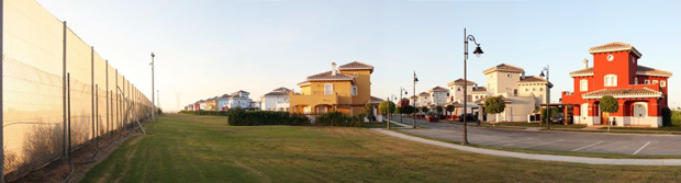
Mar Menor Golf Resort – Torre Pacheco, Murcia
3. In which way do you want this work to affect the people and society?
It is difficult to say how a particular project modifies the perception of a situation. In 2006 the real estate bubble was about to burst, but the public perception was saying “prices are never going to drop”, “we are the biggest growing economy in the world”, “keep building, buying, and selling, make money”. Mass media and politicians were basically denying the real estate bubble or saying that the process of land destruction was not sustainable. It was uncommon to address this topic. Nowadays, we can watch and read multiple news, documentaries, and exhibitions about a contemporary ruin or the economic crisis, but that was not the case back in 2006. It is impossible to measure that impact.
However, we were not alone in this task. There were other people talking about these issues as well. An example, El tsunami urbanizador español y mundial from the late Ramón Fernández Durán, or Ramón López de Lucio, that used our exhibition, among other things, to talk about the urban expansion and the backdrops of the star system architecture. A year later, the Observatorio Metropolitano published a complete study of Madrid that delved deeply in the economical, social, and urban aspect of the situation. Madrid ¿La suma de todos? Globalización, territorio, desigualdad, and Derivart published casastristes.org.
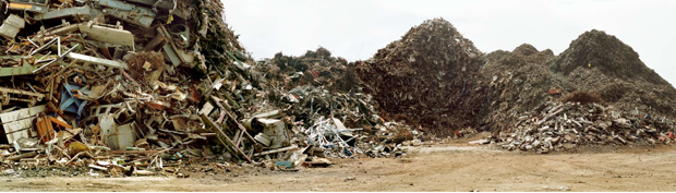
Junkyard Hermanos Lopez – Parla, Madrid
4. Which is the next phase of growth/development your research is undergoing?
We went from the regional scale, Madrid conurbation, to a country scale, Spain, in 6.000km. We created an online map at meipi.org/6000km to display how our research evolved and to open both the information and participation to the public. We went to many of those places to document the sites. We have a full list available of all the studied locations, as we have realized before in Meipi, that maps are not the only way to show spatial information, and that lists can also be very useful.
Global scale: Since we’ve been travelling often to America with Basurama in the last years, we are now exploring ways to talk about these situations on a global scale in PAN AM, Panorama Americana.
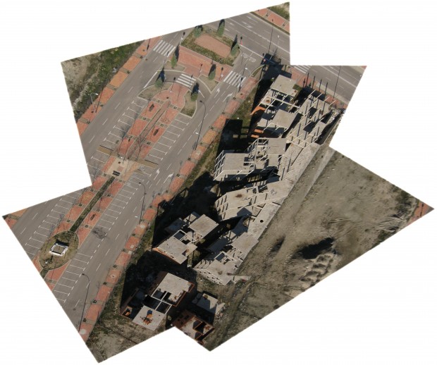
Ruins in Vallecas, Madrid – Click to view original map
Photos from the sky: We are also exploring new ways of exploring the territory with cheap balloon mapping technology. Our first results from Spain could be seen in the ruins at PAU del ensanche de Vallecas. Since last year we’ve been collaborating with the Public Laboratory in Boston, where we are mapping the evolution of an ash landfill in the suburbs of the city, Incinerator Landfill in Saugus, MA, USA, as well as mapping the waste locations from Cambridge, MA.
Civic maps: I am involved in a tool kit about civic mapping that will be released this year by the Center for Civic Media.
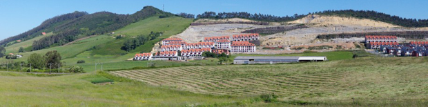
Alto del Cuco – Pielagos, Cantabria
5. What are your personal references for the theme of mapping (from ancient to contemporary ones)?
References come from many places: data visualization researchers like Edward Tufte; open hardware and cheap tools by Public Laboratory; Ushahidi and Crowdmap for collective info about maps; vojo.co for collective reporting from cheap phones; and online cartography tools like OpenStreetMap, where we are contributors and try to draw landfills and other non represented places in the map.
All the photos of the article are under a Creative Commons Attribution 3.0 Unported License and are made by Rubén Lorenzo Montero and Pablo Rey Mazón (Basurama). See legal notice.
July 19, 2013
Marielyst is a small town in the south of Denmark well known for being one of the most popular holiday locations on the Baltic Sea. Since the beginning of XX century its 20 km of white sand beaches attracted an increasing number of seasonal tourists, up to host nowadays 6000 summer houses in its area. The spatial configuration of Marielyst appears chaotic and it’s lacking of a recognisable identity; the main element of the urban structure is the principal street, a traffic vein that allows people to reach the heart of the small town, and from which secondary narrow streets start connecting every single wooden house. The subject of Marielyst competition was finding and providing a spatial organization to this place in order to structure an urban articulation among its parts. Moreover, an important feature to be considered in this site’s revitalization was the “beachy” atmosphere of Marielyst, its main character.
As usual, we worked with a multidisciplinary and international team, with the Danish landscape Office Kristine Jensen, after being chosen among 4 other finalists.

Plan
Our proposition started from the identification of the land’s shape, which changed its configuration many times until the present. In the past, the island of Falster -where Marielyst is located- was composed by three smaller islands and was crossed by water; the area had been also flooded and remained swampy for many years, until the late 1800, when it was drained. Inspired by this ancient situation, we conceived the idea of “Delta“, a sinuous and porous path that connects the dynamic activities of urban space with the relaxed atmosphere of a beach context.

Summer time
The landscape project focuses on the valorization of the great quality of the natural elements that characterize the site -pines, sea, sand dunes, dike, grass- making them stand out very clearly. The concept of “Delta” appears with the intention of spreading many accesses to these natural landmarks, connecting them through physical and conceptual paths. The Delta structure allows to pull the beach ambience in the urban space, both melted in a fluid unity; the achievement of this atmosphere is possible by choosing very soft and discreet materials to create paths and furniture elements, by substituting the current asphalt with tracks, marks and signs that simplify integration between the two ‘souls’ of the place.

Witer time
We elaborated one of the main aspects of Marielyst STRAND proposition, the activity plan. “Let it be fun!” is the motto we’ve chosen to summarize our idea to regenerate this area, being certain that the requalification of an urban space could not disregard the involvement of people in making the place alive.

The activity plan during daytime

Activity plan for the night
We’ve developed a series of entertaining and bizarre urban objects and we have settled them in the Marielyst area in order to provide several activities aimed to reinvigorate the site during summer as well as winter time. We have tried to get inspired by the surrounding environment to elaborate ideas that allow people to appreciate the visible and the invisible natural local elements.

Catalogue
Our proposition for Marielyst urban contest mainly consisted in designing urban objects strictly connected with natural elements that characterize the site, like rich vegetation, long beaches, fresh water and strong wind. The objective of our urban design strategy for Marielyst was to transform this ordinary beach on the Danish coast in a unique and very attractive site that could easily become a reference point for people who want to spend funny holidays in sustainable way.

Catalogue
The catalogue includes elements to enjoy the view of landscape from above (the watching tower, the balloon in the sky); elements integrated in the vegetation that allow to take advantage of its amenity in an unconventional way (the hammocks, the spider net, the hanging chairs, the fireplace); objects that transform the beach in a big playground (the playful tower, the oversized playground); objects that use wind to catch its power and transform it into energy (the windmill lamp) or just exploit its strength to create ephemeral landmarks (the wind fish, the wind parade).

Catalogue
Other elements are mobile and contribute to constantly change the configuration of the place, like the rolling cabins -temporary supports for sport activities or refreshment bars-, or the vehicles on wheels, a kind of elaborated bikes that could be used to move along the city and create temporary stages, movable slides, or on the road benches. Moreover a big attention is given to the socializing areas, as the rooftop terrace of an existing building along the main street, the picnic area or the water cloud, a playful object very useful to refresh atmosphere during sunny days of Baltic summer.

Catalogue
June 14, 2013


Next Thursday June 20th registration will be closed for the International Summer School, in which more than 20 teachers and 40 students will develop new forms of architecture, particularly related to tourism, in the valley of Solanas and in the coastal area in the south-eastern part of Sardinia.
Did you miss that call? Here is the original post about it: Coastal Landscape Architectures | International Summer School in Sardinia

Important information:
Registration is closing on June 20th!
Save the dates: July 3rd – July 13th
Special deal for European students: 50 € fee + 100 € for 10 days lodging
Learn more about this experience: coastal-landscape-architectures.blogspot.it
June 4, 2013
Starting July 3rd, Jose Luis Vallejo and Belinda Tato from ecosistema urbano will be joining more than 20 teachers and 40 studens in an International Summer School organized in the valley of Solanas (Sardinia) by Department of Architecture, Design and Urban Planning at the University of Sassari in collaboration with the Municipality of Sinnai.

The objective of the Summer school is to develop new forms of architecture, particularly related to tourism, in the valley of Solanas and in the coastal area in the south-eastern part of Sardinia. The development of new forms of architecture in coastal areas requires alternative approaches to the traditional scenarios of seasonal tourism. Teachers, students and public servants will be working together to face challenges related to the economically instable and unfavourable conditions created by seasonal tourism. The environmental contexts studied are sensitive and fragile, yet, at the same time, they are sites of great potential for developing innovative solutions and new uses. The activities of the workshop will aim at enhancing this potential by using the specific qualities and resources of the various contexts presented in the area.
If you are studying in Europe, you will get a special deal: Students coming from European universities only have to pay 50 euros for fee + 100 euros for 10 days for lodging + travel (there are cheap low cost flights to Cagliari).
And you’ll get to spend those 10 days learning, collaborating, walking and bathing in front of this great landscape… so don’t think for too long, registration is closing in 10 days!
Important information:
Registration is closing on June 15th! Edit: June 20th.
Save the dates: July 3rd – July 13th
Cost for European students: 50 € fee + 100 € for 10 days lodging
Learn more about this experience: coastal-landscape-architectures.blogspot.it
May 16, 2013

Hello Wood is a multicultural and multidisciplinary art program. Their most well-known event is the one week creator camp held every summer, where recognized experts and artists share their knowledge with talented students.
All work produced is carrying two attributes: it’s mostly from wood and it’s characterized by an interplay of art and social commitment. Hello Wood integrates various fields of art, design and science; it creates community and encourages talent. It brings together students and professionals across borders, moreover connects everyday people with the designer community.
We are researching how could the bond amongst nature, our artificial environment and humans become tighter. With the tools of design and architecture we are looking for an answer to the question: How could we get at least a step closer?
Hello Wood will focus on designing and creating 8 wooden installations. Considering past experiences (everybody prefers to build) in 2013 they will not separate the workshops by profession.
Besides architects, experts from different fields of art are invited as well to apply. You can be an architect, painter, sculptor, landscape architect, graphic designer, musician, ninja etc. The application procedure offers an equal opportunity for everyone.

Here you can see some samples of previous projects: The snail, Tornado, The Egg (featured above), Landscape Box… You can see more examples at the oficcial website.
We leave you with a video of last year’s edition. It looks FUN!
More information:
Official website: hellowood.eu
Photo gallery: Momeline on Flickr
Video gallery: Momeline on Vimeo
Social networks: HelloWood on Facebook
January 10, 2013
Today we introduce Francesca Rotundo, a young architect who is doing an internship with us, being mainly involved in our proposal for the competition in Kiruna and the Reggio Children experimental centre.

As she tells us:
I’m a quite curious person, careful observer of what is happening around me. My interests are many, but somehow the architecture field seems to contain or connect to a lot of them, giving me everyday something different to think over.
I’ve studied architecture at the University of Ferrara, graduating at the end of 2012, and, as Erasmus student, at Chalmers University in Göteborg, Sweden, a great experience that made me fall in love with the nordic atmosphere, and made me more passionate about my work, in particular about investigating the relation between citizens and the design of the city.
As I wanted to keep widening my horizons, I was especially excited about gaining a Leonardo-program grant and having the chance to join EU, here in Madrid. Participating with them in a university-workshop about the regeneration of borderline areas, organized by Ri-Generazione Urbana, I had the possibility to know them more and I found their way of working very inspiring. I think it’s awesome to collaborate with such a great studio, matching my interests.
Apart from the complexity of the city, which I enjoy so much, in my quite small home town I take part in a cultural association called Primola together with architects and artists, working to make vital the local territory and preserving its landscape. We organize events and activities related to culture, entertaining, designing and realize sets and installations using lights and “poor” building materials, like straw bales.
Trying to conceive design in a playful way, I always keep in mind the social impact of architecture and, as we never stop learning, I keep looking for answers and new questions as well.

Here is a short summary about Francesca:
Occupation: Architect
Interests: Architecture-landscape-city, urban safaris, travelling, Illustration, fashion & industrial design
City/country: Cotignola-Ravenna, Italy
Web: Portfolio
Online profiles: Facebook, LinkedIn
February 2, 2012
Today we are very glad to introduce you to Marta Battistella, one of our most recent collaborators.

Marta is a graduate student at 4Cities, a European master in urban studies which takes students to Brussels, Vienna, Copenhagen and Madrid. Previously, she also studied visual arts and theater in Venice and landscape design in Vienna.
To the question “Where are you from?”, her answer is both open and precise: 30% from Este, 30% from Venezia, 20% from Wien, 5% from Modena, 5% from Bruxelles, 5% from København and 5% from Madrid.
She is mainly interested, among other topics, in cultural theory related to urbanism and public spaces, landscapes, contemporary dance and photography. A wide and rich profile that brings new approaches and perspectives to the agency, so we are sure we will be sharing interesting debates and experiences with her at work during her internship.

Welcome, Marta!
Edit: During her stay at Ecosistema Urbano, Marta wrote a very interesting series of posts about digital social tools for the city. You can check them here: Social Toolbox | Marta Battistella
February 1, 2009

[bracket] is a collaboration of Archinect and InfraNet Lab, and is composed of a collection of diverse editors and an open-source contributing membership.
[bracket] is an annual publication documenting issues overlooked yet central to our cultural milieu that have evolved out of the new disciplinary territory at the intersection of architecture, landscape, urbanism and, now, the internet. It is no coincidence that the professional term architect can also now refer to information architects, and that the word community can also now refer to an online community. [bracket] is a publishing platform for ideas charting the complex overlap of the sphere of architecture and online social spheres. continue reading