Comments: (0)

looking at the invisible side of cities | the role of relationality in the urban context

Category: ⚐ EN+architecture+city+research+urbanism

Poster_time-frames.psd

Today we publish a text written by Claudia Scholz and Louise Brandberg Realini.


What is the surrounding that influences the way we evaluate and imagine a single architectural building? The following text sets the stage for the interdisciplinary research project The role of relationality in urban transformation processes, about the conception of space and time in urban transformation processes. The study was driven by the question how the relational texture of a city influences urban transformations and how these transformations in turn change the city’s relational web over again. The text looks at the definition of the relational texture.

A building can never be isolated from the environment that surrounds it; and that does not merely include the landscape, which visually embrace the site, but also the images born out of diverse associations, all of which are legitimated by reasons of sensations. Memories and affections existing only in our imagination are not less real or of less importance. Their visual absence in the material world does not prevent them from influencing our behaviours and judgments in the same manner as physical objects do. We walk along streets for the most irrational reasons: for a particular bakery, a past encounter or just the way it makes us feel. Sometimes places become associated with an event, and we treasure them for that rather than for their form. Even if the proper buildings are gone, the memories linked to them may live on and continue to influence us. At other times, the arrangement of buildings may have become lived up with meaning. The buildings do not matter themselves but only as a configuration. Space in-between them makes them meaningful.

Beside the ‘invisible’ reality a single site may have, we also need to consider the ‘invisible’ relationships that every site has with its surrounding. Sometimes other sites are used to explain a specific situation; sometimes other sites make important issues more evident. Sometimes also buildings in their development process can be changed by their context, as the situation in itself could alter the building welcoming it to the context or rejecting it. Discussion around apparently unrelated objects may push the development in one or the other direction.

Hence, before intervening with something new in an existing network we need to understand and make sense of the situation we are in, what the surrounding is like beside its emblematic manifestations, its famous monuments, what are the visible and invisible relations, past and present ones, that may act on the new projects. Our thought is that in the ‘invisible’ we find important hints on how to handle transformation processes, set up projects and cues from which a particular architecture, something new, may emerge.
We would like to offer another view on the urban reality that may help to ground projects on the stories, not only the histories, of places. It is a loose framework for the design of architectural intervention, one that includes other views beside the one of the architect, the planner or the investor. The thought is to inspire architects and planners to generate new projects that emerge from within as being part of an existing reality.

The challenge therefore is to come up with something that would surface the underlying and rather ‘invisible’ relationships and reveal the finer nuances of our environment. These nuances escape the conventional reading of space and are not easily captured with the traditional tools of the architect. Synthetic observations rarely illuminate all existing dimensions.

To trace the invisible, the complicity and imaginative gift of the citizenry must be taken advantage of. Thus, we need to interview them about their day-to-day life, about their way of looking at the built environment. Starting with more personal questions as a way to warm up and to get to know each other, then we may question more general questions: What do they see? What do they cherish? Where do they pass day-after-day? Which places serve the people’s well-being? Which are their affective places? Is there something that could improve their quality of life? Afterwards we need to be more specific in regard to specific sites asking rather specifically for their perception of them: Do they know them and what do they think of their relationship to the surrounding? What followed should be a 10 to 30 minutes’ walk, where citizens show us a piece of their city bringing us to sites they like or even dislike, to places they often walk by or find particularly interesting in Lugano.

We end with a wide collection of urban stories: from a child’s accident on the main square, the routine of nightly walks in an inner urban green valley to the last singular tree along the lakeside, that subsequently can be coded to one of the five temporal time-frames (see table time-frame). It offers an understanding for which places may be altered and to which point, what would be welcomed and what would probably be rejected.

The urban stories are not only personal episodes. Many of the stories also belong to others or might have been experienced by others. Hence, they have a higher collective significance and are more present in the collective memory. These ‘collective places’ are not only conventional representative places, but also smaller venues like bars, bakeries and nameless streets.

An emotional colored map will emerge around the objects of investigation, where also series of links among sites become evident. These may help to understand its surrounding and hence, frame future intervention. This vision is another reading of today’s reality, where sites – beyond functionality, form and usability – represent the territory from the citizens’ point of view with its atmosphere, its emerging problems and themes. More than a must follow manual it is ‘food for thought’ that may help architects to take position, build structure and unite diverse parts of reality. It wants to unfold the values of those we build for today. Ignoring them, we risk that our designs are rejected or misunderstood. These values need a continuous assessment because as society change, also our behaviours change. To bring it further and work with digital tools would be a next step to do.

More information:
Scholz, C. & Brandberg Realini L. (2012) Multiple perceptions as framing device for identifying relational places, Swedish Design Research Journal, 2: 38-45
www.urbanrelation.org

Authors:
CLAUDIA SCHOLZ (March, BArch) and LOUISE BRANDBERG REALINI (March, BArch) are both
co founders of CODESIGNERS, a Lugano-based studio for architectural designs, strategies and research. The studio is involved in landscape design, strategic planning and consulting.

Comments: (0)

#networkedurbanism: Your Digital Opinion is Important to us

Category: ⚐ EN+networkedurbanism

Place Pixel

Earlier this year we introduced to you #networkedurbanism, now that the “studio report” book is almost ready, we are publishing a series of posts showing some of the projects that the students have developed during the 2010, 2012, and 2013 studios at the GSD.

In this fifth #networkedurbanism post we present to you two projects that share the aim to enrich the physical space with a digital layer, the connection between real and virtual worlds was one of the recurrent themes in the studio and these two projects truly create a strong link between them allowing people to express their opinion about the physical city using digital means. continue reading

Comments: (3)

LibreLigne | Urban acupuncture in Libreville, Gabon

Category: ⚐ EN+city+competitions+ecosistema urbano+landscape+news+urbanism

Concept draft of the piers as urban catalyzers

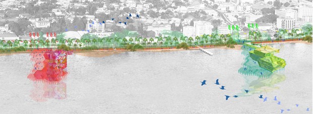
Concept drawing of the piers as landmarks

Ecosistema Urbano was recently selected as one of the five finalists in a competition of ideas for the waterfront (Bord de Mer) of Libreville, capital city of Gabon. We were selected by the committee of the Agence Nationale de Grand Travaux du Gabon among many other proposals. In their own words, the proposal “has strong linkages to existing urban systems, improves coastline’s connections and celebrates Libreville culture and history.” Here is a brief descripton of the project:

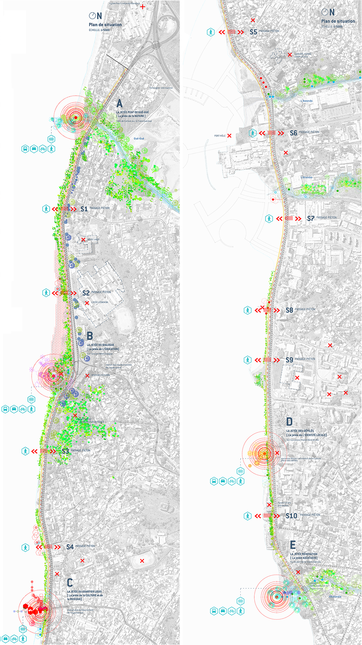
The main goal of our proposal is to reunite Libreville with the seashore, and extend the life of the city to the waterfront in some specific points. This would be achieved through operations of urban regeneration, adjusted to the existing and to the specific cultural, sociological and economical context. The proposal concentrates visual impact, identity and activity in five nodes, instead of spreading them too thin along the promenade.

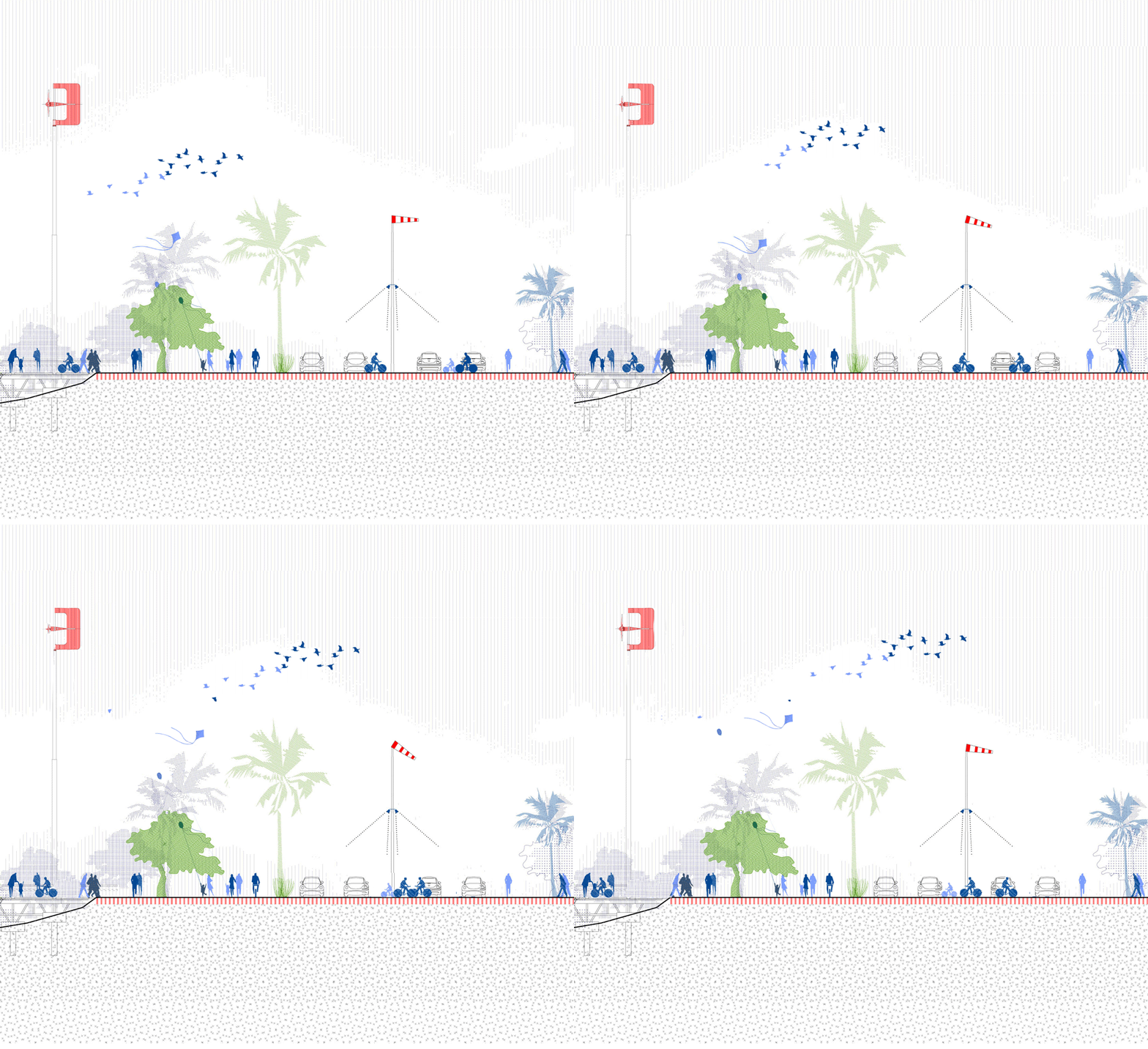
Plan of the coastal line of Libreville, in two sections

Plan of the coastal line of Libreville, in two sections

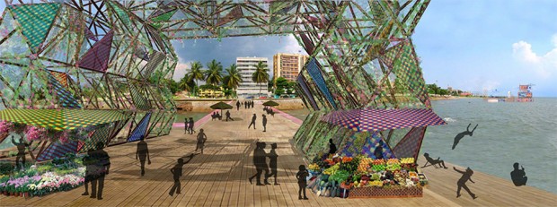
Those five pier-like structures (jetées) are a great way of getting closer to the water, of having a unique view of the city and at the same time of providing space for programs that could work as catalysers of the urban life. They act as unique landmarks, breaking the regularity of the very long promenade and facilitating the orientation of citizens. These points of “urban acupuncture” would drag attention and pull the urban life of Libreville to the seashore, providing a new space for citizens to interact.

Vertical section of the biggest 'jetée'

Section of the biggest ‘jetée’

Section of one of the piers

Section of one of a longer and lower pier structure

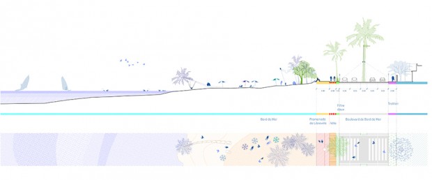
Section through the beach

Section through a beach area, where the promenade is reduced to the minimum

The locations and uses of the piers are defined in relation to the city: to its flows, to the activity of the closest neighbourhoods and to the most relevant uses, buildings or public spaces nearby. Following that close relation with the surroundings, each pier has a singular character defined by the size, the shape, the vegetation, the dominant colors and other design factors, but also by the specific set of activities that can be performed in them. This way, we have the pier of Nature, Education, Culture and Music, Local Identity and Water.

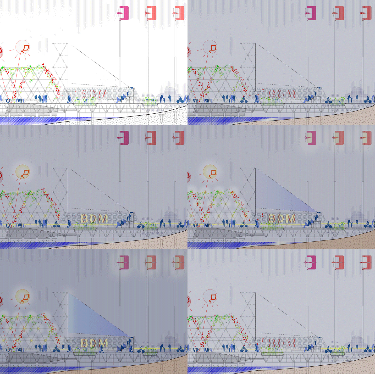
One of the pier structures evolving along the day

The use of the structures would change along the day

On the other hand, the linear promenade itself changes the configuration of its section depending, again, on the surroundings. Some key elements are defined in that section: the waterfront boulevard for (unavoidable) motorized traffic, a series of landscape markers (associated with energy production and visibilization), a coastal bike lane, a waterfront promenade, an urban appropriable fringe… This elements are combined, stretched or shrinked, generating diverse profiles and multiple areas of interest.

One of the "pelican" crossings in front of a pier

The crossings in front of the piers would be shared areas for pedestrian and motorists

Thus, while the promenade is kept simple, regular and clean, these structures act as landmarks, dividing the seafront in more aprehensible, walkable sections, and marking the coast like ‘signal fires’ or lighthouses: they provide visual clues to help the passer-by understand his exact location at a glance.

View from one of the piers

View from one of the piers

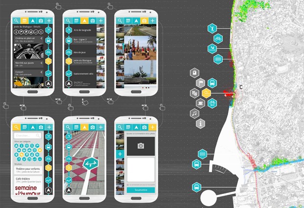
In addition, based on the rapidly rising mobile market penetration in Gabon, and as a bet on the potential of hyperlocalized digital networks for urban life, the proposal includes a digital application that would work as a geolocated and participatory cultural agenda for the waterfront, showcasing the activities along the line, attracting citizens and visitors, allowing them to search and follow events, and acting as a geographic map or guide.

Tentative screenshots of the application

Tentative mockup for the application, based on the previous proposal for ‘BikeLine’

This proposal was developed in collaboration with the landscape architecture office Uberland.

Comment: (1)

SeeClickFix, a powerful digital tool for the collective management of cities | Social Toolbox

Category: ⚐ EN+social toolbox


seeclickfix

Website: www.seeclickfix.com
Type: Application | platform
Issues: Street conditions | Accessibility | Quality of life


SeeClickFix follows a similar concept to that of the recently featured FixMyStreet and ReparaCiudad, but on steroids! It is a highly integrated digital platform which focuses on issues of quality-of-life, from simple problems regarding street and environmental conditions to more complex issues about the health of citizens and communities. continue reading

Comments: (0)

ReparaCiudad, a Spanish platform for the improvement of street conditions | Social Toolbox

Category: ⚐ EN+social toolbox

Website:  www.reparaciudad.com
Type: Platform | App
Issues: Street conditions | Mobility and accessibility


ReparaCiudad follows the same concept of FixMyStreet. It is an application that allows citizens to report incidents in the street and immediately inform the public administration, which can quickly react and provide feedback to the citizens about the solutions adopted. The application provides a mobile version and a web based version. continue reading

Comments: (0)

MetaMap | Pablo de Soto

Category: ⚐ EN+architecture+city+landscape+MetaMap+technologies+urbanism+video

Pablo de Soto is part of the generation who lived and experimented with the creative explosion generated by the web. His studies in architecture have enabled him to look at digital culture through a unique perspective. Keeping as reference, science fiction, situationism, and hacker ethic.

In 2001, he founded hackitectura.net, along with José Pérez de Lama and Sergio Moreno Páez, and a crew of architects, programmers, artists, and activists that participated in projects that dealt with themes of cartography and mapping. I interviewed Pablo de Soto about Sevilla Global, Cartografía Crítica del Estrecho de Gibraltar, and Mapping the Commons (Istanbul and Athens)

Here are a few screenshots of the maps:

Taksim Square, Istanbul

Fener Balat, Istanbul

Brook Crossing, Athens

This post is part of the MetaMap series about mapping. You can follow the conversation on your favourite social network through the #metamap hashtag.