Earlier this year we introduced to you #networkedurbanism, now that the “studio report” book is almost ready, we are publishing a series of posts showing some of the projects that the students have developed during the 2010, 2012, and 2013 studios at the GSD.
In this last #networkedurbanism post we present to you three projects held together by the common thread of time. The first one deals literally with our personal time organization, the second with the transmission of memories tied to a specific place, and the last with the the permanence of personal memories through time and beyond life. continue reading
Earlier this year we introduced to you #networkedurbanism, now that the “studio report” book is almost ready, we are publishing a series of posts showing some of the projects that the students have developed during the 2010, 2012, and 2013 studios at the GSD.
In this sixth #networkedurbanism post we present to you two projects that apply the concepts of a social network, like the ones that we generally use—twitter, facebook—to the physical world using digital locally-targeted apps or physical objects. continue reading
Website:www.peuplade.fr Types: Platform Issues: Encounters | Neighborhood initiatives and public events | Commons and services | Sharing culture and experiences | Exchange of knowledge and skills
Peuplade (“Tribe” in French) is an experience launched in Paris in 2003 in the Epinettes (XVII°) district.
Thanks to the enthusiastic involvement of its first partners, Peuplade gained popularity and success, and is nowadays used all over France, Belgium and Switzerland. It is a social project founded by “Les Ingénieurs Sociaux” (“social engineers”), an enterprise which deals with the development of tools intended to offer people, associations, enterprises and institutions the means to give a more human face to interpersonal relationships, to society and to economy.
Peuplade is a space for encounters, exchanges, innovation and initiatives, offered to inhabitants of a same street, neighbourhood or city. continue reading
Website:www.seeclickfix.com Type: Application | platform Issues: Street conditions | Accessibility | Quality of life
SeeClickFix follows a similar concept to that of the recently featured FixMyStreet and ReparaCiudad, but on steroids! It is a highly integrated digital platform which focuses on issues of quality-of-life, from simple problems regarding street and environmental conditions to more complex issues about the health of citizens and communities. continue reading
Website: www.ziudad.es Type: Online platform Issues: Streets’ conditions | Mobility and accessibility | Social issues and public services | Environment | Sharing culture and experiences
Ziudad is a digital platform whose goal is the common “definition” of cities by their citizens. It is a social network that facilitates the communication between citizens and municipalities, between consumers and enterprises. In Ziudad citizens can collaborate for the notification and resolution of urban problems, can directly communicate problems to the municipality, make a complaint or propose ideas for the improvement and development of their city and its quality of life.
To kick off with the #SocialToolbox series, here is one of the first and most remarkable −almost ‘classic’− examples of an urban social tool bridging the physical “body” of the city and the digital “soul” where humans and data interact.
FixMyStreet is a site to help people report, view, or discuss local problems they’ve found to their local council by simply locating them on a map. It launched in early February 2007. FixMyStreet is primarily for reporting things which are broken or dirty or damaged or dumped, and need fixing, cleaning or clearing, such as: abandoned vehicles, dog fouling, flyposting or graffiti, flytipping or litter, streetcleaning, such as broken glass in a cycle lane, unlit lamposts, potholes. continue reading
Accurat is an information design agency based in Milan and New York, founded by Giorgia Lupi, Simone Quadri and Gabriele Rossi in 2011.
They define their work as the following:
We envision and identify new ways to structure information, revealing and addressing latent needs, desires and opportunities. Basing our methods on the design thinking approach, we specialize in providing our clients with consultancies, services, and products related to information design. Focusing on how information is transforming networks, cultures, contexts, and behaviors is an attempt to understand the future, a demonstration that it can be intercepted and designed.
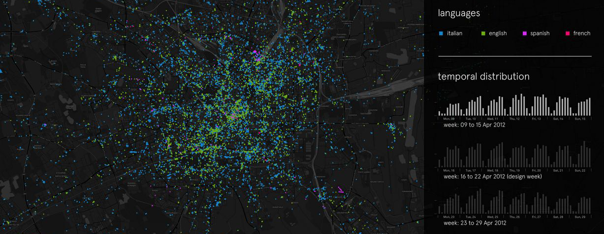
I interviewed them about Big Data base maps and about their ongoing work in mapping: ✳Urban Sensing.
Experiment of Tweet mapping in Milan during design week
1. How did you get to the practice of mapping?
To us, mapping could be seen in a broader context as “structuring information”.
To start off, it’s not needed to say that information related issues are at the core of any design project that deal with cities, public services, society, and behaviors regardless of scale. Particularly, we have always been interested in urbanrelated projects that deeply rely on information: contexts, analyzing data, designing analytical tools, and visual narratives that provide awareness and comprehension of changing urban dynamics.
In our past entrepreneurial experiences, at Interactiondesign-Lab, we experimented working between the intersection of information systems and urban dynamics within the design of the Plan of Services for the Municipality of Milan (developed between 2009 and 2010). We designed a plan not to be intended as a product or document, since it was developed as a continuous process of listening, monitoring, reporting, and crossing the needs and the offers in terms of services of the city.
We designed 2 tools at 2 different scales, the macro scale of the city and the micro scale of the neighborhood. These tools don’t define what services we plan to have, but they give directions on how to cross the demand and the possible answer in terms of services in a meaningful way. It was, in fact, an information design project.
2. In what way do you obtain and treat the data for your mapping?
A big mapping project we are currently working on and coordinating at Accurat is ✳UrbanSensing.
The ✳UrbanSensing project is a EU funded project which aims to design and develop a platform for extracting patterns of use and citizens’ concerns with city spaces, through robust analysis of User Generated Content (UGC) shared by city users over social networks and digital media. The platform will allow the user to analyze citizen’s perceptions related to specific geographic areas and understand how population reacts to new urban policies within participatory mechanisms.
Novel digital and telecommunication technologies can be deployed to integrate data-sharing platforms within the spatial dynamics of the city. If properly analyzed, geo-tagged and User Generated Content (UGC) coming from Twitter, Facebook, Foursquare, or Flickr can be useful in the creation of meaningful, real time indicators of people’s perceived and communicated urban experiences. Through natural language and network analysis, it is possible to identify the nested micro-narratives that shape the behavioral and semantic background of a place and to extract specific urban indicators.
Our assumption is that by conducting an analysis of datasets based on text extracted from UGC we can recognize multiple stories, as they emerge, overlap and influence each other, unfolding from city users’ mental representations and spatial experiences of city spaces. In fact, by providing tangible, visible references, the spaces of actual buildings and cities participate in constructing the meaning of the speech that articulates itself within them and as conversations unfold within particular architectural settings, they build up increasingly dense webs of shared understanding grounded -at least in part- on the points of reference that these settings afford.
Thus, within ✳UrbanSensing we are mainly gathering and analyzing geo-localized social media data (Twitter, Foursquare, Instagram, and Flickr); and such data will be properly integrated and compared with more traditional sources of urban information (socio-demographic territorial data, real-estate indicators, and environmental data) to produce dynamic and evolving images of the city as used and perceived by its’ citizens and temporary users.
3. What is the application of open source/social network-based mapping you are interested in the most?
If properly analyzed, integrated, and interpreted, Social Media data can help stakeholders at the urban scale to “forward-looking” innovation strategies based on a thorough analysis of people’s contexts, interests, and needs.
Among the possible urban topics this data could partially answer to, we will narrow them to the following particular issues:
Rapidly intercepting emerging urban dynamics, such as gentrification processes and precise areas’ evolution through time (for identifying trends in areas’ related phenomena, in the exact moments they’re originated, with the possibility to add more dynamic parameters to those used by the real estate market);
Understanding which are the factors (e.g. morphological aspect, aesthetic quality, public service availability and density, infrastructure granularity, cultural scene, and commercial service) that attract people in particular places (areas, neighborhoods), and how this evolves through time;
Understanding which kind of people (language / on-line influence / demographics) are in specific areas at particular moments;
Highlighting patterns of movement throughout the city (from which places people in an area come from? where are they going? are they residents, visitors, or ordinary city users?);
Interrogating data about a particular topic (e.g. brand name, event name) or about a selected theme (e.g. cultural phenomena, cutting-edge topics) to see how things evolve spatially and temporarily.
All this, to provide a better understanding of an areas’ related phenomena and evolution, to redefine actual districts’ fixed boundaries and to see where public services, policy’s infrastructures, design interventions, or activities could be better located, and to try and build models to predict near-future evolution;
Experiment of Tweet mapping in New York
4. What is the next phase of development that your research is undergoing?
One of the forthcoming steps of our project is to gain a deeper understanding of:
How such data sources could be interpreted (in terms of sharing behaviors and motivations) to get actual and consistent insights;
Which are the real limits of such data in terms of research (e.g. demographic, digital divide, economic, location-related);
How to overlap and integrate such data sources with more traditional layers of territorial information (e.g. socio-demographic data, income data, rental costs, ethnic data, and environmental ones such as pollution and sanitary inspections, etc.) to finally display extreme high-resolution views and interpretations of territorial related dynamics.
How unexpected patterns and meaningful questions could emerge from data themselves.
In fact, UGC differs from conventionally produced geographic information in several aspects. The source of the information, the technologies for acquiring it, the methods and techniques for working with it, and the social processes that mediate its creation and impact. Traditionally, geographic information has been produced by experts and institutions, therefore, certain types of information have been privileged and other types ignored, and even marginalized. UGC’s represent a powerful shift in sources, content, characteristics, modes of data production, mining, sharing, dissemination, and use. Therefore, a wide set of meaningful questions (that have been partly investigated for “conventional” geographical information) need now to be re-investigated, and a framework on how to use these information still has to be built.
In parallel, we are designing and developing the technological architecture and the actual interface allowing us (and lately, stakeholders) to perform specific queries and produce such dynamic maps in a very visual and intuitive way.
5. What are you personal references for the theme of mapping (from ancient to contemporary ones)?
We would here focus on emerging critical practices that propose new models to describe the city that stresses the collaborative and constructionist dynamics of the mapping process.
The underlying idea of this approach considers the geographic, urban experience through a network of multiple fragmented temporary data and information generated by human-place interactions and collaborative dynamics. Based on these theoretical premises, several experimental GIS-based applications focusing on cartography emerging from users’ perceptions and activities have been produced.
As Zook & Graham noticed, traditional methods used to register users’ perceptions and activities about the cities and its fruition – like surveys and ethnographic reports – seem to be inadequate to meet the need of information of contemporary society both because they require a considerable amount of resources (in terms of time and money) and because they do not consider the temporal dimension.
Senseable City Lab explored mapping systems based on UGC on several projects like World’s Eyes and Obama One People.
Current City, a European foundation committed to address long-standing city management problems in unconventional ways, explored the potential of urban mapping based on real-time data streams on users’ location coming from telco providers.
Christian Nold’s work focused on in-depth research of technological tools in order to unravel their social and political layers, and on building socially constructive, bottom-up devices, that take the form of practical tools such as in the Bio Mapping project.
Bio Mapping is a research project based on biometric sensors that can be worn by users provided with a GPS device able to trace their paths through the city, and that register specific parameters (e.g. emotional status in a specific place or situation) and publish them as user generated content on specific emotional maps. This project explores tools that allow people to selectively share and interpret their own bio data. Within this framework, Nold investigates how the perceptions of a community in an environment can change when they become aware of their own intimate emotional status.
Some other recent GIS projects focused on the idea of building open tool-kits that could be used by the community of students and practitioners of urban design, planning, and management. The Centre for Advanced Spatial Analysis at UCL created MapTube as a free resource for viewing, sharing, mixing, and mashing maps online and the NeISS project (National e-Infrastructure for Social Simulation) provides a platform to meet the demand for powerful simulation tools by social scientists and public and private sector policymakers. The tools enable researchers to create workflows to run their own simulations, visualize and analyse results, and publish them for future discovery, sharing, and re-use. This facilitates development and sharing of social simulation resources within the urban planners and social science community, encourages cooperation between model developers and researchers, and helps foster adoption of simulation as a research method and as a decision support tool in the public and private sectors. Design Tool is an application proposed by Predrag Šiđani, which has its starting point in Lynch’s propositions about city and urban form. Lynch’s theory of urban form and its hierarchical structure of main urban elements were applied, together with his concept of cognitive mapping, to a conceptual model of the Design Tool.
This is the second post in the MetaMap series about mapping. You can follow the conversation on Twitter, Google+, Diaspora, or Facebook through the #metamap hashtag.
credits: Giorgia Lupi and Gabriele Rossi (accurat.it) acknowledgements: texts above are part of the ✳UrbanSensing project
Design Week Tweets: Accurat with Marco Vettorello (data gathering) and Paolo Patelli (data processing and visualization)
Thanksgiving: Accurat with Marco Vettorello (data gathering and processing)
Today I want to share an article that was previously published in Studio Magazine. On this occasion, I would like to thank their coordination team for inviting me to join their first release.
Summary /Overview
Traditional media don’t broadcast what the citizens are debating or organizing on a daily basis. Nevertheless, thanks to Social Networks, people can receive information and interact in real time with others, taking part in debates and social movements; and the 15th of May in Spain is an example of this.
This new information ecosystem reduces the influence of the mass media and slowly forces local authorities to relate to citizens in a more direct and horizontal way.
This is a great opportunity to generate a new “social control” model, pushing local authorities to take public opinion into account.
The digital media offers a broad environment for communication so that the organisation of any given action is greatly improved; everything becomes decentralized while simultaneously connected and synchronized.
On the urban scale, we speak of the “Sentient City”, a model based on a technological/social ecosystem, where knowledge, collective actions, and interactions between individuals and groups are encouraged, taking advantage of the new possibilities offered by hybridizing physical and digital layers.
In reversing the supremacy of centralisation over individual actions, citizens can become aware of their power and organize themselves on the web.
We have the necessary technology, knowledge and dynamics to put in place more open processes of urban administration and management. Citizens have already started to move; and although public administration could take advantage of such independent and autonomous processes to deal with complex situations, it appears that a clear political will is still lacking.
The fragmented city
Today, the dimensions of time and space, which were historically strongly linked in a space-time continuum, are increasingly growing apart and becoming independent, in a fragmented spatial perception. Nowadays a large number of people are moving from one point to another of the city to reach their workplace, and go back home. The distance between these two points (spatial dimension) and what happens between them does not affect or interest these people in any way. Indeed, the only thing people are concerned with is the duration of the trip (time dimension).
The city is no longer a continuous place, but a structure of nodes connected in a network (network city). These nodes become increasingly more defined, organised and efficient and, the journeys between them shorter and faster thanks to technical progress. The spaces of a city that have no particular characteristics and a unique function, that is to say everything that is not a node, loose significance, including public spaces.
In such city – the “fragmented city” – we use low cost technologies (internet, telephone and transport) to move, to manage our social relationships, and to communicate with people with whom we don’t necesarilly share a common physical space like a neighbourhood.
Very often the complexity of one point exclusively consists in giving access to other points, hence the importance that movement has acquired today. Instead of living in a continuous space, we continuously move between discontinuous spaces (points or nodes).
This networked structure, unlike a continuous structure, reduces diversity and complexity. The less diversity and complexity, the greater the need to move. Every point has its function and identity. Everything seems more organised and easier to find. However, to find what we are looking for, we are compelled to move constantly to other nodes.
The majority of these journeys are done by means of transport, at a speed that does not allow any relationship with the surroundings. There is a starting point and a finishing point, with little opportunity for a surprise or a change. All this implies an impoverishment of the intermediate spaces, spaces that link different points: places are consequently public spaces.
In order to transform these kinds of cities, it is essential to intervene in everyday aspects of life which might appear to have no relationship with the design of public spaces in urban areas.
Our lifestyles are two dimensional: in situ and virtual. Now we are able to intervene in the new dimension, what we commonly call “virtual” or “digital”, . As the sociologist Manuel Castells says “Everything we do, from when the day begins until it is over, we do it with internet […] the connexion between in-situ (not real because reality is virtual and in situ at the same time) and virtual is established by us. There are not two different societies, there are two kinds of social activities and relations within ourselves. We are the ones that have to search the best way to arrange and adapt them.
According to Daniel Innerarty, in the city the homogeneous and non changing area is nothing more than an extreme case within a global area of connected local multiplicities. Instead of neighbourhoods, local networks are developed, and public debate takes place in a virtual area. In this scenario, streets and squares have ceased to be the main meeting areas.
Internet seems to offer an alternative “space” for social relationships as compared to “traditional” spaces. This can be seen as a problem leading to empty public spaces; or on the contrary, it can be considered an extraordinary opportunity to strengthen social relationships by creating the necessary budgets to improve the vitality of public spaces. Today the Internet is the “place” where community models of management are being experimented.
I believe it is important to reconsider the city as something built by everyone, and to see public areas as the ground where this process can take place. Today we have tools available that are able to act as a catalyst for participatory dynamics that were previously impossible to coordinate. There are increasing examples of processes of creation by citizens, linked to the use of new technologies. It is undeniable that Internet is a key factor contributing to changing the society. That being said I believe it is obvious that we cannot think of public space without taking into consideration the potentialities of these technologies, how they are used and how they can be an added value.
We should begin to talk about a new type of public space, a hybrid space, where technology could become a catalyst for hybridising dynamics between activities that are not traditionally connected or that are located in other (private) spaces.
Juan Freire explains this clearly: “The differentiation between spaces and physical and virtual communities is outdated. We are witnessing a hybridising process which modifies our individual identities, communitarian and territorial. Internet has contributed to the development of global networks, but paradoxically it has had a less noticeable influence in local spheres. However, digital technologies modify radically the way in which we are organised and we relate to our environment so we are already living in territories where the digital realm is as important as the physical. The hyper-local networks and hybrid public spaces are the new realities which we confront with the advent of Internet and digital culture in our local environment”.
According to Juan Freire the crisis of public (physical) spaces in urban areas is also due to the lack of (open) design, giving the citizens, once more, the opportunity to take a real interest in its use. It has also brought into debate concepts such as “hybrid spaces”, to refer to the opportunities that the hybridising of the physical with the digital sphere offers in public spaces.
We can grant the assumption of the existence of a digital skin that characterizes public spaces and devote ourselves to defining its qualities and characteristics. Instead of “hybrid” I like to use the concept of “sensitive”. “Sensitive space” refers to the “living” character of these spaces; to their capacity to promote a two-way relationship with its users, to catalyse hyper-local social networks and to visualise information related to the environment in a transparent manner.
If we analyze the increase in the use of social networks on the Internet we realize that we are witnessing a process of change that will lead to the disappearance of the current dissociation between digital and in-situ identity.
Most people can continue living in complete normality without having to take care of their digital (identity) presence in social networks. Nevertheless, it is highly probable that in a few years time the concept of identity will inevitably integrate both the digital and the physical dimension. Consequently, each person will be forced to take as much care of their digital identity as of their physical identity, something that many people have been doing for some time already.
We must take several specific factors of this new kind of identity into consideration such as its peculiar time dimension. The building process of the digital identity over time leaves a footprint on the web, a visible footprint that is accessible to any user. The end result is an identity that is perceived as a sum of the past (footprint) and present identity.
Generally we control our public image by showing at each time only what we wish. However, when our identity leaves a footprint on the internet, we no longer have exclusive control over it but it is shared amongst friends and acquaintances (namely the peer group).
Each person that knows me can publish information (photographs, texts, etc…) that are directly or indirectly related to my identity without the need of my approval. This is what happens in most of the social networks.
Certainly, my digital identity will be entirely integrated in the learning process and will be increasingly associated to a physical space; that is, the idea we had about a parallel digital identity that is detached from reality does not, I think, interest anyone: in fact we do not even have time to create parallel identities.
Our identity is not only formed by way of the information that my friends and I have published, but also through the information that my devices publish. An example could be the use of services like Foursquare that allows me to upload posts in my social networks about my location at any time, taking advantage of the internet connection of our mobile phones.
To explain this phenomenon Tim Berners-Lee mentions Giant Global Graph, this means, the future Semantic Web with which we shall go from gathering the relationship between people to focus on the relationship between people and their interests (documents). Thus, if the “Internet” has allowed us to connect computers and the “Web” has allowed us to connect documents, then the “Graph” will allow us to link the documents (places, objects, etc.) and the people. So we could define the Graph as the third level of abstraction, taking into account that in each layer (Internet, Web, or Graph) we have handed over some control only in order to reach bigger benefits. A direct consequence of these dynamics is the definite statement of a (unique) identity on the web that can be recognized by any agent, person or application.
This unmistakable digital identity facilitates the development of innovative social hardware projects based on participation of a non-collective nature, where the dynamics of collaboration are the result of individual action and interaction. We are progressively discovering the self-organisation of informed societies that are capable of revolutionizing their own structures taking advantage of the virtual mirror phenomenon that enables the association of information on a given situation with individual decisions.
Social networks reinforce a new type of control: a decentralized control operated by a diversity of independent individuals that collaborate, using shared and mobile capacities of calculation and communication. Information and Communication Technologies do not present a solution, but an opportunity to improve our ability to manage territories. ICT’s can be used for many different purposes. On the one hand their enormous capacity for processing data can be used to centralize all the information and try to “solve” urban complexity; but they can also be used to open and decentralize decision-making.
The aim is to research on how ICT’s allow us to define an urban administration structure where discontinued points of control exist in an environment of self-determination (appropriation) and liberty. This is an idea that is close to the definition of tensegrity that Buckminster Fuller mentions: “islands in compression inside a tense ocean“.
The introduction of digital technologies within the physical space enables the development of new communication dynamics and relations between neighbours that improves the cohesion of local communities and their quality of life, offering a feeling of greater security.
Thanks to new technologies and to some cultural “mutations”, systems and worlds that were previously closed and not very transparent, are now open to the participation of agents (and people) who are external to their organisational structures. Citizens become more available to participate and collaborate because they are better informed and they are finally considered as useful partners for the urban administration. Architects and urban planners can reasonably begin to work keeping in touch constantly with citizens, “sharing” their decision-making “powers”.
To explain this phenomenon we can refer to the concept of “long tail” coined by Cris Anderson. The Internet and the digital environment have changed the (power) distribution laws and the market rules. The present political and economic system is based on a pyramid structure where the power (or the economic or creative potential) of many is considered inferior to the power of those that stand on the highest part of the pyramid. There is a new system based on the addition or accumulation of all the small potentials (or powers) of the mass of citizens that, thanks to the systems of communication on the internet, can equal or exceed the power (or potential) of those who are in a privileged position today. These are the old markets of masses and the new niche of markets that are pictured at the top and the bottom of the well known graph of statistical distribution.
The presence of a centralized identity is not needed when the control and feedback devices allow the actors to visualize or to become aware of the consequence of their actions. The unconscious self-organisation phenomenon becomes conscious and intended control when the individuals are allowed to understand the effects of their actions. The concept of tensegrity comes in here when it refers to an administration model where decentralized and centralized decisions are joined, avoiding the appearance of any closed and omnipresent control dynamics.
Reversing the supremacy of centralization over individual decisions, citizens can become aware of their actions and intentionally coordinate them. This process may help to restore the necessary legitimacy and credibility to the interventions that take place in degraded urban areas.
Towards participation: Accountability and open data
“Participation demands an information system, an observatory and indicators that will regularly reflect the situation of what we consider as key variables to establish our evolution, that should be accessible and comprehensible for citizens” (Agustín Hernández Aja, 2002)
In 2002, Hernández Aja, Urban planning professor at the Universidad Politécnica in Madrid, describes the essential assumptions for citizen participation. A decade later, communication models and administration dynamics that bring us close to these assumptions start to become popular.
I would like to highlight (point out) accountability and the Open Data movement.
Approaching the term accountability we can create an ecosystem of communication and transparency that can enable citizens to demand responsibilities from governing bodies. This would help us to reach the objective of decentralizing control, which is necessary for a true democracy.
Open Parlamento (openparlamento.it) is a great example of how to work to achieve accountability. It is a web-based tool that enables distributed monitoring of the work of the members of parliament in the Italian parliament.
The web page offers lots of information on draft legislation, and in general, about all the activities in the Parliament. Most interesting of all is the distributed monitoring system that allows for control of every Member of Parliament’s political activities. Every citizen can “adopt” a member and publish all their declarations and confront them with their parliamentary activity.
We can imagine this same system applied on a local scale, where citizens have greater organization capacities and power to exert pressure. The control to which all the local administrators would be subject to, would be so intense that they would nearly be obliged to start up a transformation of the administrative structures towards a more open and participatory model.
The Open Data movement is an important drive towards achieving transparency over public administration. Open Data consists of making Public Administration data available for the public, such as data related to projects that are financed with public money or managed by public institutions.
The aim is to take advantage of the data that the public administrations do not want or do not have the capacity to analyze. Releasing this data enables any person or organization to build new consultation and visualization formulas, to simplify, diversify and even to enrich the initial information.
In Spain, within this new tendency, the Open Data Euskadi project should be highlighted. It is part of the Open Government initiative of the Bask Government: a website dedicated to the exhibition of public data in a re-usable format, under open licenses. On an urban scale, two projects stand out that have been activated by two Spanish cities; Zaragoza and Córdoba. They are beginning to take their first steps in the world of Open Data.
I am convinced that citizen pressure will force all the big cities to join this process of openness and transparency.
As we mentioned previously, reversing the supremacy of centralization over individual actions, citizens can become aware of their “power” and begin to organize in networks.
We have the technology the knowledge and the dynamics available to introduce more open urban administration processes. Citizens have begun to move; the administrations could take advantage of these autonomous and independent processes, to manage very complex situations. However, a clear political will is still lacking.
Probably the administrators have managed to delay the transition towards a new participatory administration model, thanks to the indirect or even direct support of what is known as the “fourth power”: the media. The current information system still offers the administrators and the “powerful” a wide opportunity to manipulate and control certain processes.
The emergence of a more distributed information model is beginning to offer to any citizen the possibility to produce relevant local information. A communication ecosystem based on social media is born.
This new information ecosystem can reduce the influence of the mass media and therefore force the local administrators to enforce accountability regarding the decisions that are taken. The administrators will be compelled to relate to this new, more horizontal and distributed form of communication: an opportunity to generate “social control” that can improve transparency and force the local administrators to take the public opinion into account.
A clear example of what is being presented here, are the latest citizen mobilizations that are happening in Spain. After the 15M demonstration, an organized and authorized event, many occupations took place in numerous squares in the whole of Spain. These camps were organized in a matter of hours using Twitter and Facebook. It is impossible to exert control over these information flows and action catalysts like the occupations. Steps have been taken towards a model in which governors and administrators are going to have to understand that they cannot continue to ignore the citizens while they defend the interests of others.
We are witnessing an innovative construction process of a new communal and public sphere; the development of a new model of public space that we have called “sensitive space”. Traditional media don’t communicate what we the people are debating on a daily basis, nonetheless, thanks to Social Networks, people can receive information and interact in real time with others taking part in debates and social movements, the example of the occupation of public squares is an example of this.
It is interesting to note that the in-situ (on-site) realm is absolutely essential and how the digital media is simply offering a wider environment for communication so that the organisation of any given action is greatly improved; everything becomes decentralized while at the same time connected and synchronized.
These processes seem to be nearly inevitable. Once they are established as natural local administration processes then we will be speaking about a more favorable environment, for an Open Source City, that is, a city open to everyone’s participation.
While preparing the URBACT Biannual report, we came upon an interesting innovative educational tool – ATLAS OF DIVERSITY. Composed of a network of schools, the ATLAS uses mutual collaboration to generate one of the most important and world extensive database on cultural diversity.
Como comentaba al final de la semana pasada, euabierto.com empieza a funcionar. Ahora estamos buscando voluntarios para coordinar y representar ciudades y escuelas del mundo. De momento ya tenemos los representates de dos ciudades: Ciudad de mexico y Granada. continue reading