Comments: (0)

New workspaces, connecting the physical and digital spheres

Category: ⚐ EN+architecture+competitions+creativity+ecosistema urbano+research+technologies

ph+dg_654

During the past months, in the framework of a shortlisted competition for a new working+retail space in the Middle East, we developed a research about the possibilities of contemporary workspace and how the digital layer influences the physical configuration, enhancing and multiplying the possibilities.

Last Fall we were teaching at the Master in Workspace Design at IE University, leading the Technology Lab; so this exploration became a continuation of our previous research and work.

We have been studying the contemporary way of working / thinking / living, analyzing the current phenomena affecting the spaces where the working activities take place. We believe that the digital revolution and contemporary socio-political dynamics call for reflection on the way we work. Spaces and instruments for working, methods and hierarchies, places and distances have all been brought into question. Beyond and around working, there is an ongoing change of paradigm that involves almost every aspect of culture and society. The way we address and manage processes, products and knowledge is evolving aided by new technological possibilities and critical “meta” reflections: From competition to collaboration and cooperation; from centralization to P2P; from pyramidal structures to grassroots, horizontal ones; from professional secret to transparency; from private R&D to crowdsourcing; from intellectual property restrictions to copyleft and free/open source initiatives, from well finished products or services to open roadmaps that embrace perpetual beta…

Our research focused on the following challenges:

How can architectural, physical work space, aided by its digital equivalent through hybrid interfaces, incorporate those emerging ways in order to support further exploration?

How can we, architects/designers, provide the best built environment for these emerging impulses to become fully developed?

Our philosophical approach divided the subject into three main spheres of research:

+ The Physical Sphere
Understanding the contemporary workspace as an innovative and experimental balance between design (size, material, color, behaviour, structure, relative position between elements,…) and conditioning (hygrothermal comfort, privacy, noise levels, lighting,…) to be implemented so as to be responsive and truly supportive.

Print

+ The Digital Sphere
We focused on the digital “cloud” associated to each space to enable experimental environments, unprecedented interactions and ways of communicating, or wider, faster, more open-access to knowledge. We considered the digital sphere in workspaces as a unique open environment, extremely user-friendly, flexible and customised according to the specific circumstances it will be used for: supporting internal work, influencing digital marketing strategies, involving customers and external visitors, instigating social activities.

Print

+ Physical-Digital Interaction
We design spaces that enable the best interaction between users relying on a physical comfort and the digital layer. We focus our work on how mutual management, communication, control, connection and interaction can work between the physical and the digital. This specifically involves physical interfaces that operate on the digital side and digital interfaces that influence the physical space.

DIAGRAMA workspaces-03

In order to achieve the integration of physical and digital spatial configuration, we developed a design strategy around four main actions we believe as relevant for an innovative workspace:

4 actions

– Inspiring
Innovation requires firstly an inspiring environment in order to provide an experimental incitement to creativity through different channels.
We believe in the possibility of feeding creativity through a series of activities that inspire our brain and stimulate it to go beyond boundaries and create big ideas.

– Well Being
A workspace should provide a high comfort level for the people using it. The environment should be equipped with all the facilities that ensure the best ambience for every particular situation and need.

– Challenging
Being satisfied by its own conditions, sometimes is not the best way to bring innovation. The only possibility to improve is going beyond and accepting challenges. In the contemporary work scene, innovation is an indisputable fact. But, for instance, how to stimulate a company that is already in the innovation sector to exceed and excel constantly? We believe that a good training in accepting new challenges even in the small everyday things could help a lot. Through simple dynamics that boost self confidence, cooperation between members of a team, enthusiasm towards the new and unknown and establishing an informal and playful way to invent new solutions for everyday issues as well as exceptional conditions is an excellent way of ensuring high levels of performance.

– Networking
We believe the strength of a successful company is in the quality of its structure and components, but just as important is the network that is able to create, expanding its connections and sharing an learning with/from others.

We keep this line of research open. So, if you want to contribute with it, by sharing a paper or article around the topic, we will be happy to publish it, to spread the ideas and inspire others!


Comments: (0)

SPACE POTENTIAL: The luscious ingredient of architecture | Video Method PLES

Category: ⚐ EN+architecture+creativity+research

How fatal would architectural discipline consider the idea to diminish the role of plans in spatial analysis and planning and acclaim the role of individual’s physical interaction with space through movement?

With the advent of the moving image, particularly within the new media, the notion of a precise reference image has become both relative and confused.1 Already in 1936 Walter Benjamin declared that since the beginning of the 20th century neither space nor time have been perceived and articulated the way they were from time immemorial.2 How we sense and perceive space is determined not only by our nature, but by historical circumstances as well.3 With the arrival of photography the relationship between reality and its representation was established anew.4 Photography announced the advent of the moving image, which gave rise to the further changes in our perception of space.5

Video Method PLES

Space Potential: Video Method PLES, image: A.H.

The process of globalisation significantly changed the landscape of motion for the contemporary man. We may choose to travel at ever-greater speeds to any place in the world within a blink of the eye or we may choose to stay isolated in our domestic environment, connected to the rest of the world through the latest technologies. The need of the contemporary man to be informed about everything at any time and place is being fully satisfied with the expansion and evolvement of the new media, particularly of the moving image. If there is a medium in every epoch that stands behind the convergence of innovations and perceptual change, thus reflecting and impacting society at large, we can postulate that the moving picture is a visual reference for the contemporary representation of space.6

Video Method PLES

Space Potential: Video Method PLES, image A.H.

With the birth of the ever more rapidly moving man, we experience an extremely complex set of parameters that determine our daily choices and visions and delineate the reference frame to our actions. We are witnessing a situation in which we can see and experience space, urban or/and natural landscape, at different speeds and various times of day, be it through the windshield of a car, the window of an airplane, the screen of a mobile phone, or simply the TV screen showing the mesmerizing alpine grasslands selling us the new taste of chocolate.7 Phenomenon that sets both ourselves as well as our living environment in motion, impacts the relationship between man and his perceptual reality Christophe Girot calls: movism.8

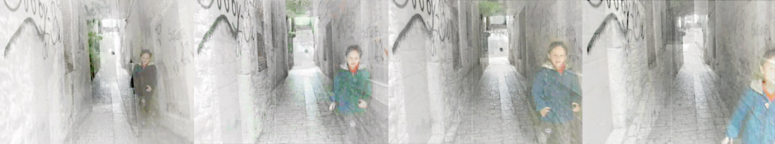
Movism is the new visual theory of landscape in movement, dealing with the fleeting essence of our epoch. It forms a base for my creation of the Video Method PLES, using video as a possible tool for analysing, documenting and presenting Space Potential. The method is discussing interaction between an individual and urban or/and natural landscape, integrating a broad spectrum of viewpoints and stimulus, which can also appear distorted. Moreover, Video Method PLES is focusing on the notion that by moving through space we perceive and experience a variety of parameters, ranging from cultural, spatial and biotic habits all the way down to phonic, tactile, visual and kinetic parameters in the landscape. Due to a strong presence of motion in our day to day experiential reality, Girot claims that individual’s perceptions have become both relative and confused: some environments may appear extremely pleasant when experienced at certain speeds and become most disquieting at others. Considering that movism changed the relationship between individual and space to an extent, where it cannot be separated from our reality, it is utmost necessary to formally and aesthetically consider and integrate it in every design process to come.9

Video Method PLES

Space Potential: Video Method PLES, image A.H.

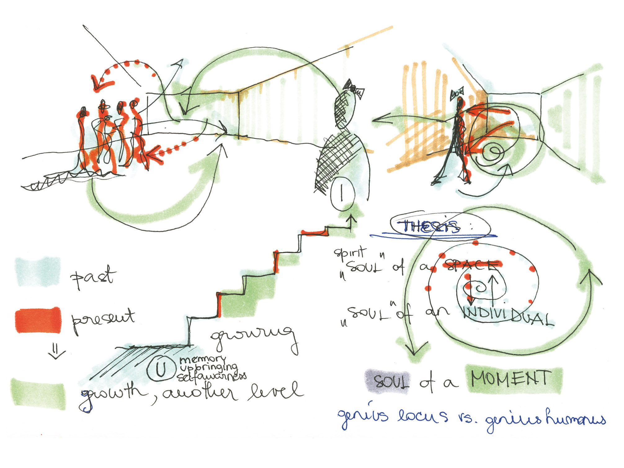
The moving image can enrich our perception, because camera has the ability of introducing us to the unconscious optics, as does psychoanalysis to unconscious impulses.10 Moreover, it functions as an inclusive approach, blending direct physical experience and intuition with Space Potential research. As for the integration of the moving image into the design process, particularly to the Video Method PLES, I furthermost see it as a medium, which provides information by means of the peripheral, unfocused vision. Peripheral vision, as opposed to the focused vision, does not fixate and is opened for interpretation, moreover it has the capability to elevate our perception of space on a level of an existential experience.11 Peripheral vision is linked to individual’s subconscious perception, manifesting through our multisensory apparatus, reviving the information stored in our subconscious.12 The appropriate condition for perceiving Space Potential with our whole being, transforming it into a complete physical experience is through Spatial Sensuousness. It gathers information transmitted through ours senses, intuition, contemplation and reason, making an individual the locust of perception, experience and interpretation of space.

Video Method PLES

Space Potential: Video Method PLES, image A.H.

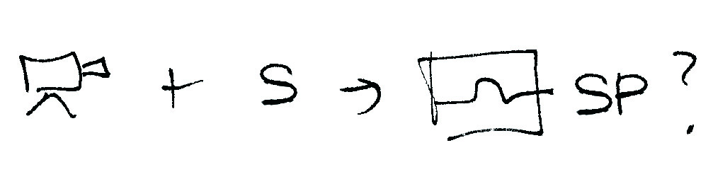
The aim of the Video Method PLES is to analyse, document and present the complete spatial experience – Space Potential. It can be verified directly on the field of action, conveying qualities of a given place that are both visible and imperceptible, but nonetheless significant, for example stories, memories and chronology. Video Method PLES combines the scientific, quantitative approach with highly intuitive, experiential and contemplative approach. The name of the method “PLES” is a Slovenian word for “dance”, which symbolizes the interrelationship between the architect and space, produced through a dynamic interaction between the two. Furthermore, PLES is an acrostic of the four phases we follow sequentially: P-rimary, L-atent, E-xperimental and S-ummary.

Video Method PLES

Space Potential: Video Method PLES, image A.H.

P-rimary phase presents the first contact between the architect and space – urban or/and natural landscape, whereby the interaction based on Spatial Sensuousness (information transmitted through senses, intuition, contemplation and reason) is established between the two. During the primary phase the architect is moving through the space, recording audio and visual information, using camera and microphone. The recorded material is not a reference for a clear and focused imagery, but documents the way architect experienced the intertwinement of existential and physical aspect of space. Primary phase represents the initial insight into Space Potential.

Video method PLES

Space potenital: Video method PLES, image: A.H.

L-atent phase evokes architect’s subconscious aspects of spatial experience. It begins when the architect returns to his or her primary environment and starts reviewing audio and visual material. Simultaneously, the architect notes down thoughts and concepts in a form of narrative monologue, which represents one reaction to spatial experience from the first phase.

Video Method PLES

Space Potential: Video Method PLES, image A.H.

E-xperiential: In the third phase, analysis, classification and selection of representative audio and visual clips takes place, as well as the recording of the narrative monologue from the second. This is the most important phase, because the discoveries about Space Potential and the given project are adjusted and unified.

Video Method PLES

Space Potential: Video Method PLES, image A.H.

S-ummary: In the fourth phase the final video is created. It may become both a reference piece and a tool of investigation, nourishing architect’s Spatial Sensuousness, revealing one’s view of space potential of the location. Furthermore, the final video can be a starting point of an architectural intervention into urban/natural landscape, offering the architect a possibility to always return watching it in order to refresh the memory about Space Potential.

Video Method PLES,

Space Potential: Video Method PLES, image A.H.

I postulate that the moving image, video in particular, is a visual reference for the contemporary spatial design. The accessibility and immediacy of moving images that are captured and manipulated in video, bring us closer to sensual and experiential depiction of the fleeting contemporary environment, and above all to movement, which is the perceptual phenomenon and experiential reference of our daily life. At the same time, video is much closer to subjective and intuitive description of any given place than a plan, which is utmost scientific and precise, but succumbs to its two-dimensional limitations.13 At this point I would like to make clear that no matter how subjective, thus relative our observations are they have a direct impact on subsequent design choices for any given place. Architect is allowed to internalize the objective realm, because “the only way to reach the objective representation of reality is by comparing various subjective images”.14

Video Method PLES

Space Potential: Video Method PLES, image A.H.

Video Method PLES is a possible tool for analysing, documenting and presenting Space Potential, because it has the ability to capture and to present qualities of both physical as well as of existential aspect of space.15 It reduces the Euclidean space and gives us an opportunity to operate with the dimension of time, which reveals qualities of Space Potential that are otherwise difficult to capture, such as rhythm, stories, atmosphere, the passing of time and movement.16 Interaction with space with a camera, creating and analysing videos, enables architects and designers to acquire the understanding of the existential aspect of space, perceiving more of Space Potential. This enables architect’s interventions to be in tune with general spatial characteristics in cultural dimensions of the contemporary landscape and the inhabitants of the time being.

 Video Method PLES

Space Potential: Video Method PLES, image: A.H.

I believe that returning to space acknowledging the importance of the moving body and its multisensory perception and their inevitable interrelation with the subconscious way of interpreting space is necessary for identifying utmost of Space Potential. As architects we need to acquire the understanding of Space Potential in order to be able to carry out our spatial interventions wisely and knowledgeably. Considering that introduction to a site and interaction with it has all too often been reduced to systematic and quantitative formulas for analysing the site indirectly, from a distance, ways that do not grasp the potentiality of the reality we leave in. We need to accept and internalize both the conscious and the subconscious means of gathering information about Space Potential and reconcile our senses with the science.17

Video Method PLES

Space Potential: Video Method PLES, image A.H.

The aim of Space Potential Plarform is to trigger thoughts and induce actions, leaving enough space for individual engagement and interpretation of suggested directions. Sensing and perception are inherently subjective, the only correspondence to reality is the one that what we as humans agreed upon. However, I believe we may use architecture as a vehicle to enrich and create experiences and interpretations of space that will be shared among our fellow human beings, sparking further changes in our agreement about Space Potential.

Footnotes:

1. Christophe Girot, Cadrages I. (Zürich: gta Verlag, 2002).
2. Christophe Girot, »Four Trace Concepts in Landscape Architecture«, Recovering Landscape, Essays in Contemporary Landscape Architecture, James Corner, ur. (New York: Princeton Architectural Press, 1999), 59-67.
3. Walter Benjamin, “The Work of Art in the Age of Mechanical Reproduction”, Illuminations, Hannah Arendt, ur. (New York: Schocken Books, 1969), 217-252.
4. Ibid, p. 59-67.
5. Walter Benjamin, “The Work of Art in the Age of Mechanical Reproduction”, Illuminations, Hannah Arendt, ur. (New York: Schocken Books, 1969), 217-252.
6. Christophe Girot, Cadrages I. (Zürich: gta Verlag, 2002).
7. Ibid
8. Ibid, p. 48.
9. Christophe Girot, Cadrages I. (Zürich: gta Verlag, 2002).
10. Walter Benjamin, “The Work of Art in the Age of Mechanical Reproduction”, Illuminations, Hannah Arendt, ur. (New York: Schocken Books, 1969), 237.
11. Juhani Pallasmaa, The Eyes of the Skin, Architecture and the Senses. (London: John Wiley & Sons, 2005), 10.
12. Ibid, p. 10.
13. Christophe Girot, Cadrages I. (Zürich: gta Verlag, 2002), 48.
14. Anja Humljan, video project at Aalborg School for Architecture and Design, department for Digital Design, Aalborg University, 2006.
15. Christophe Girot, Cadrages I. (Zürich: gta Verlag, 2002), 51.
16. Ibid, p. 9-52.
17. Christophe Girot, »Four Trace Concepts in Landscape Architecture«, Recovering Landscape, Essays in Contemporary Landscape Architecture, James Corner, ur. (New York: Princeton Architectural Press, 1999), 59-67.

Comments: (0)

Collection of e-papers on Collective Intelligence in ArXiv | Link + download

Category: ⚐ EN+downloads+findings+research+resources

If you are interested in collective intelligence, crowdsourcing, collaboration, reputation mechanisms, collective decision making and related topics, then you’re in for a treat!

Collective Intelligence - Illustration by vladgrin on Shutterstock

Collective Intelligence – Illustration by vladgrin on Shutterstock

The page may look unimpressive at first sight; you could say it’s pure ‘Internet 1.0’, but the contents are really worth a careful look. Along with full e-papers, it contains poster papers and abstracts from plenary sessions at the MIT. They are usually available as downloadable PDFs and in other formats, sometimes even including video.

2012 collection of e-papers on Collective Intelligence – arXiv

ArXiv is one of the oldest (1991: that’s pre-World Wide Web!) and most well-known repositories for electronic preprints of scientific papers in different fields of science which can be accessed online and downloaded. It is now hosted and operated by Cornell University, with 14 mirrors around the world.

Comments: (2)

Guidelines to build participatory and inclusive societies

Category: ⚐ EN+architecture+art+city+creativity+placemaking+research+sustainability

portada_654x254

In order to achieve the Post-Master called Urban Research Lab Sardinia – Environmental Design at the Università di Sassari (DAP), in partnership with the Dessau Institute of Architecture (DIA) of Anhalt University of Applied Sciences, an article will be published about the project made during the italian period, under the supervision of Ecosistema Urbano: Punto d’incontro.

This is an excerpt of the introduction, including some references and case studies.

The role of the architect

The role of the architect has always been, throughout ancient and modern history, a reference point for the city growth and development. Nowadays, this figure is undergoing a massive transformation, which cannot ignore social aspects. The modern architect helps to integrate production processes within the spaces users live and use in everyday life.

The article aims to present an experiment that was personally led in a very specific local community in Sardinia (Italy) which is affected by logistic, economical and management problems. Through theoretical studies and personal analysis of a variety of existing projects, a detailed process was drafted in order to suggest a strategic action plan.

Western society has scarce resources and the European architect often asks the following question, what can I do now without nothing? In this hard times, it is far more difficult for closed solution to be imposed by a power minority than for specific temporary actions to be applied based on grassroots talks, because sensitivity is high and social groups are highly resistant to accepting any changes which have not come from within their ranks. Ecosistema Urbano (2011). “Negotiating at all level”. A + T 38. 120

fountainhead_654

Strategy & Tactics

The first input to the change came with the drafting of Agenda 21, a voluntarily implemented action plan of the United Nations with regard to sustainable development. It emphasises that broad public participation in decision making is a fundamental prerequisite for achieving sustainable development. The main goal is trying to involve the local communities in the construction process of the future of the cities. When public space is concerned, there are two ways to run over: strategy and tactics. Both are tools of equal value, but with different typology of method; they are usually known as top-down or bottom-up processes.

Tactics are actions which take place on enemy territory while strategy is always enacted on home ground. Which can lead to an immediate run-of-the-mill sharing out of roles: strategy is an instrument of power, tactics are used by citizens; strategy occupies space, tactics play out in time; strategy is used to control, tactics to protest. De Certeau, M.(1988). The Practice of Everyday Life. University of California Press

Recent developments of these concepts became well known under different name, but in essence they are all the same.

Tactical urbanism. It is defined as small-scale improvements in an effort to effect large-scale, long-term change.
Placemaking. It is the act of enlivening public spaces and places for the betterment of the community and its neighbors.
Participatory design. It is an approach to the assessment, design, and development of technological and organizational systems that places a premium on the active involvement of workplace practitioners (usually potential or current users of the system).

The following scheme represents the stages of the experiment:
Process_654

The Iberian trip

There was the necessity to analyze the theory, exploring some case studies and finding some references. This processes are already very disseminated all over the world, especially in USA and north Europe, where the citizens have a great sense of community and cooperation.

Nevertheless this research focused on the Mediterranean area, in this particular case in the Iberian peninsula, where the lack of organization meets high quality and creativity, typical of the Latin culture. Some of the cases shown here are real established structures, others are spaces under construction and constantly changing. The connecting link is always one of active participation.
iberian trip_654

LXFACTORY – Lisbon

An urban fragment, kept hidden for years, is now returned to the city in the form of LXFactory. A creative island occupied by corporations and professionals of the industry serves also has stage for a diverse set of happenings related to fashion, publicity, communication, fine arts, architecture, music, etc.

lx_factory

El campo de cebada – Madrid

A group of neighbours called Distrito Centro promoted a temporary use of the vacant lof of a former public pool demolished in a district of Madrid, during the time in which the work planned for urban reuse was not to be carried out. The intention is that the space will accommodate all types of proposals/activities/projects (cultural, social, artistic, sport) for the use and enjoyment of the people of the district and all the city.

cebada

Matadero – Madrid

The old slaughterhouse and livestock market, where Matadero Madrid is now located, was built according with the project of the architect Luis Bellido. The site was architecturally transformed.
Matadero Madrid’s mission is to promote creation in all its forms and expressions. With special attention to cross-sectorial propositions, it focuses on three main action areas: training, production and dissemination.

matadero

Fabra i Coats Creation Factory – Barcelona

Fabra i Coats is a multidisciplinary space which will be promoting artistic hybridisation to become a point of reference in artistic research and in the generation of new quality contents, as well as a meeting point for groups, creators and proposals from different spheres and backgrounds.
The goal is to give support to artistic creation and it has workspaces for the performing arts, music, plastic and visual arts, multimedia creation and also for projects related to information and communication technology.

fabra i coats

Sometimes these kind of actions are not supported by a physical space, but by the people that build their spaces through some collective iniziatives, occasionally supported by a politician organization or made by self-funded artistic groups.

Urbact

It is a European exchange and learning programme promoting sustainable urban development. They enable cities to work together to develop solutions to major urban challenges, reaffirming the key role they play in facing increasingly complex societal changes. URBACT spans over 500 cities, 29 countries and 7,000 active participants.

urbact

Collectif ETC

Born in Strasbourg in 2009, this collective gathered energy around a common dynamic questioning of urban space. Through different means and different skills it wants to be a medium for experimentation. They believe that the different users of the city (residents and professionals) can all be involved in its development to a wide range of scales. The purpose and importance of these urban experiments is not only the result but also the process that generates it, as well as the new environment and new behavior it generates.

colletif etc

Boa Mistura

It is an urban art group formed at the end of 2001 in Madrid, Spain. Its members have diversity of perspectives, distinct visions which complement each other, and combine to create something unique and coherent.

boa mistura

Madrid Street Art Project

It is a noprofit association that through the organization of various activities and initiatives (urban Safaris, workshops, lectures, recovery rooms) aims to contribute to these reflections, to encourage citizens to enjoy urban art, contribute to its dissemination and support its creators.

madrid street art project

Conclusions

The final article will aim to give some semi-scientific guidelines to build participatory and inclusive societies. The new frontier of the architect should be to drive local communities in the management of public and private space, involving them in the construction process of the urban renewal. This is when the architect, as a highly knowledgeable technician, plays an essential role to mend the relation between politicians and common people.

02_654

Comments: (0)

The Water Footprint: Every drop counts!

Category: ⚐ EN+city+research+sustainability

The water footprint of an individual, community or business is defined as the total volume of freshwater that is used to produce the goods and services consumed by the individual or community or produced by the business.

The water footprint consists of three components: the blue, green and grey water footprint. The blue water footprint is the volume of freshwater evaporated from the global blue water resources (surface water and ground water) to produce the goods and services consumed by the individual or community. The green water footprint is the volume of water evaporated from the global green water resources (rainwater stored in the soil as soil moisture). The grey water footprint is the volume of polluted water that associates with the production of all goods and services for the individual or community. The latter can be estimated as the volume of water that is required to dilute pollutants to such an extent that the quality of the water remains at or above agreed water quality standards.

The past century has brought a lot of changes, like the explosion of human population, the creation of an expansive global economy and the increasing technological development. All of them have put unprecedented pressures on water. More specifically, our growing appetite for water-intensive food and manufactured good, the construction of large dams for hydro-electricity and irrigation, and the massive discharge of industrial waste into limited freshwater sources, have made water an increasingly limited and expensive resource.

Despite this obvious fact, people use large amounts of water: drinking, cooking and washing, but even more for producing things such as food, paper, cotton clothes, and almost every other physical product. This water can be named as virtual water.

The virtual water content of a product (a commodity, good or service) is the volume of freshwater used to produce the product, measured at the place where the product was actually produced.

It refers to the sum of the water use in the various steps of the production chain. The virtual-water content of a product can also be defined as the volume of water that would have been required to produce the product at the place where the product is consumed (consumption-site definition).


Image made by Virtual water | facebook.com/virtualwater

Here are some examples of water footprints of daily products , calculated by Unesco-IHE Institute for water education, Netherland

Image made by Hoekstra and Chapagain 2008

These numbers are kind of shocking! Aren’t they?

So, let’s try to calculate our daily footprint and investigate the solutions to reduce the numbers as much as we can!

Image made by GOOD and Fogelson-Lubliner

Water footprints can be hard to calculate, depending on how far up the chain of production you go, since everything you eat and buy used some water to produce. With our latest Transparency, I give you some examples of how much water is used in some of your daily activities, so that you can begin calculate your footprint and try to reduce your gallons.

To help put things in perspective, think about this: your standard trash barrel holds 32 gallons and a mid-sized passenger car-if pumped full of water has room for a little more than 800 gallons. So, the difference in the amount of water it takes to produce a pound of chicken and a pound of beef is enough to fill almost two whole cars.

Which result have you got?

Let’s compare it with the water footprint calculation of one friend of mine, Croatian architect Ana Bilan that did some research in that field.

According to her calculations she was able to reduce her water footprint more than twice, which sounds really impressive!  So it was a matter of changing her habits, decreasing the direct water footprint and also the types of food she eats and products she uses to get a better result with indirect water Footprint.

Image made by Ana Bilan | research about MY WATER FOOTPRINT | for IED Torino Master SUS


If you become really interested in knowing how much water you personally use per day, you can follow this link and make a simple calculation:

Water footprint calculator (adults)

And you can also involve your kids into the idea of water preservation!

Water footprint calculator (kids)

Here are some facts to convince you to be a water guardian:

  • The average American lifestyle is kept afloat by nearly 2,000 gallons of H2O a day—twice the global average;
  • 46% of people on the earth do not have water piped to their homes;
  • Women in developing countries walk an average of 3.7 miles to get water;
  • In 15 years, 1.8 billion people will live in regions of sever water scarcity

A complete update of facts and stats about the water global crisis has been recently (2017) published by John Hawthorne, available at this link.

And remember – Every Drop Counts!

Comments: (0)

Urban land teleconnections and sustainability

Category: ⚐ EN+research+sustainability+urbanism

Review of the paper “Urban land teleconnections” by Karen C. Seto, Anette Reenberg, Christopher G. Boone, Michail Fragkias, Dagmar Haase, Tobias Langanke, Peter Marcotullio, Darla K. Munroe, Branislav Olah and David Simon.

Recently a research paper was published in Proceedings of the National Academy of Sciences (PNAS) concerning the conceptual development of global sustainability, in relation to both urbanization (urban sustainability) and land change. The paper argues that land change and urbanization dynamics are explicitly connected, and suggests “urban land teleconnections” as a new framework for dealing with global sustainability.

Urban Land Teleconnections

“We propose urban land teleconnections as a process-based framework for integrating urbanization and land change, for revealing their linkages and pathways across space and time, and for identifying potential intervention points for sustainability. Through the lens of urban land teleconnections, new and surprising diverse urban forms and processes, such as periurbanization, can be better understood and foreseen. The urban land teleconnections concept could also be useful to the wider research community to anticipate implications for global land resource use.”

More and more people live in the cities. The increasing urbanization is raising many discussions about sustainable planning, and this recently published paper feeds the debate with new inputs. Encouraging a reconsideration of the terms on which we base sustainable policies, the research is widening again our perception of the relationship between the urban field and land. The term “teleconnections” refers to climate science, where it is understood that events have impact over large geographic areas – when the waters of the North Atlantic go through a warm phase, fire incidents increase in the western United States. Just such urban land teleconnections explain the interrelation and invisible bond between urban processes and land use processes, which we must consider when planning our sustainable future. The key to develop strong sustainable planning, is to stop thinking of urban sustainability and land use sustainability as limited to local scale and place, and instead start to take into account the processes and global connections merging urbanization and land use.

“The virtual shrinking of distances between places, strengthening connectivity between distant locations, and growing separation between places of consumption and production are emerging topics in “telecoupled” human–natural systems and tropical teleconnections of deforestation […] In an increasingly urban world, characterized by global flows of commodities, capital, and people, where land that provides goods and ecosystems services for people is becoming more segregated from the space of habitation, teleconnections captures links between distant processes and places, and can be used to explore consequences of urbanization and land changes at great distances from points of origin that would otherwise go unrecognized.”

Urban Land Teleconnections

Urbanization and land change have so far been treated as parallel processes. Apparently this has limited the progress of the concept of sustainability. The paper states that a simultaneously treating of urban sustainability and land change as interwoven, non-separable processes is the keystone to advance in developing sustainability:

“The magnitude and accelerating rate of contemporary urbanization are reshaping land use locally and globally in ways that require a reexamination of land change and urban sustainability. Worldwide, urban populations are projected to increase by almost 3 billion by 2050 and the total global urban land area by more than 1.5 million square kilometers—an area three times the size of Spain—by 2030. Urban economies currently generate more than 90% of global gross value added, meaning few rural systems are unaffected by urbanization (3). Given such trends, we must reconsider how we conceptualize the many connections and feedbacks between urbanization and land change processes.”

The paper is confronting three understandings of the urban – land relationship that so far have been key themes in sustainability policies.

One is the Land Classification Systems, on which the paper states:

“By definition, because urban is human-dominated, urban areas “appropriate” natural ecosystems, ecosystem services, and natural capital. By this logic, urban cannot be natural capital. However, such a conceptualization contradicts underlying principles of urban ecology as well as sustainability.”

The second theme is Place-Based Definitions:

“The place-based conceptualization enforces the idea that urban sustainability requires urban self-sufficiency. […] However, decisions and behaviors that are local or even regional in scope do not account for critical consequences of teleconnections, which may undermine sustainability efforts at great distances or influence the overall sustainability for the entire system. Eating locally might undermine livelihoods of distant farmers who may be using less energy-intensive methods to produce food than local growers. Put another way, sustainability initiatives often focus on the importance of place while ignoring the processes of urbanization that may have farreaching effects on distant places and people. These processes can generate uneven and undesirable outcomes that may be undetected when focusing solely on place.”

On the third theme, Land Transitions, the paper argues:

“[…] Although not always explicit, a common assumption is that land transitions in Europe and North America can help understand future trends in Asia, South America, and Africa. Such assumptions disregard the realities that cultural differences influence conceptions, codifications, and uses of space and land, and that use of distant land to meet demand for local populations can significantly alter the pathways of change. As a result, there is no universal or linear transition process; phases identified in one context can be shortened, prolonged, overlapped, or even omitted or transgressed elsewhere.

Urban Land Teleconnections

Urban Land Teleconnections is suggested as a new key theme, a framework to address sustainability. In an immediate invisible network, urbanization and land change are constantly in a process of affecting one another. The term itself indicates that the concept of sustainable urbanization and sustainable land use has merged. Conceptualization of sustainability should contain both processes at once.

“By using an urban land teleconnections framework, we move away from conceptualizing urban sustainability and land as attributes specific only to a place, to begin to link dynamic global processes to their spatial “imprint”.”

This means that changes in nonurban places affects urban places and that change in urban space affects nonurban space. In this way, urban and land relations are interwoven in a global network wherein neither the themes Land Classification Systems, Place-Based Definitions nor Land Transitions can stand alone to define the framework for developing sustainable concepts.

“ […] we can study multiple urban regions jointly, rather than trying to aggregate and generalize across many disconnected sets of case studies, and consequently provide a more organized way to integrate knowledge globally. A more holistic analysis of the underlying and spatial effects of production, consumption, and disposal will enable development of policies that promote viable and fair solutions, and ultimately global sustainability.”

Further reading: Urban Land Teleconnections paper – PDF

Comments: (0)

bring buddy | a new approach to goods transportation | #followresearch

Category: #follow+#followresearch+⚐ EN+research


Last friday at the event rebel matters, directed by Manuel Gausa and Mosè Ricci that took place in the University of Genoa, I had the opportunity to meet Christian Schärmer, an austrian designer based in Barcelona from proxidesign.net. He made an interesting presentation talking about design thinking showing different samples of his own work and some other references. continue reading

Comments: (0)

Nearer, better

Category: ⚐ EN+research


Photo Credit: Kyungjoon Lee

Link found between physical proximity of researchers, impact of work

The above schematic represents the relationship between intra-building collaboration and citations. The height of each building reflects the average number of publication citations originating there, and the color reflects the degree to which authors on those publications cohabitated (from gray=low to blue=high). The graphic depicts that, in general, buildings with more intra-building collaborations produced studies with higher citation rates.

Absence makes your heart grow fonder, but close quarters may boost your career. continue reading

Comments: (3)

You are where you live

Category: ⚐ EN+city+research

Researcher looks for link between people’s health and where they live
We know that smoking causes cancer, yet we still light up. We know that overeating causes obesity and diabetes, yet we still overeat. We know that exercise makes us healthier, yet we can’t resist the couch’s siren song.

We all want to be healthier, and we know how to become so. Yet we just don’t do it.

S.V. Subramanian, associate professor of society, human development, and health at the Harvard School of Public Health and a researcher at the Center for Population and Development Studies, has heard all of the theories explaining why living a healthy lifestyle is so difficult. We’re predisposed to pack on pounds to survive the famine that, in olden days, was certainly coming. We’re addicted to the nicotine in cigarettes and the fat in burgers, which get their hooks into us. Convenience is key: Who can drag themselves to the gym every day and cook healthy meals of nuts, fruits, and vegetables when the golden arches beckon? continue reading

Comments Off on #followresearch: Marta Guerra Pastrián

#followresearch: Marta Guerra Pastrián

Category: #follow+#followresearch+⚐ ES+paisaje+research

Hoy iniciamos una nueva sección #followresearch donde publicaremos trabajos de investigación que consideramos relevantes. Presentamos el trabajo de Marta Guerra, arquitecta a la que conocí el pasado mes de Agosto  en nuestro primer viaje a Boston por el inicio del curso en Harvard.

Marta Guerra Pastrián es Arquitecta por la Escuela Técnica Superior de Arquitectura de Madrid y Urban Designer por la Universidad de Columbia de Nueva York, donde estudió gracias a una Beca de la Fundación Cajamadrid. Ha vivido y trabajado en Madrid, Nueva York y Boston. Trabaja junto a Pablo Pérez Ramos, y ambos centran su interés en la intersección de las disciplinas de la Arquitectura, el Urban Design y el Paisaje, y especialmente en los espacios [ sub]urbanos en procesos de transición y semi-abandono. Actualmente trabajan y estudian en Cambridge, Massachussetts. continue reading