Comments: (0)

How to make streets livable in the traffic-packed city of Dhaka

Category: ⚐ ES+city+design+dhaka+mobility+urbanism

Trying to drive along a street in the Lalbagh area, in the city center of Dhaka.

Trying to drive along a street in the Lalbagh area, in the city center of Dhaka.

After getting out of the airport in Dhaka, the first thing we noticed—the first thing every visitor notices—was the traffic. As we were heading to our hotel in a taxi, the streets around us were crowded: trucks, taxi, private cars, rickshaws, auto-rickshaws, pedestrians, carts with horses… All transportation modes were sharing the same space among clouds of dust, smoke and a cacophony of sounds, without any apparent organization.

How could some of these roads be turned into walkable, human-friendly streets within a short period of 5 years? continue reading

Comments: (0)

Being a pedestrian in Dhaka

Category: ⚐ EN+city+dhaka+mobility+urbanism

Stuck between a street vendor, his living hens and a rickshaw (first mean of transportation in Dhaka), trying to cross a four-lane road in the middle of an intersection among clouds of dust… being a pedestrian in Dhaka can look like a risky adventure.

In 2016, Dhaka was the 11th megacity in the world with 18.237.000 inhabitants. In 2030, the UN estimate that its population will be around 27.374.0001 inhabitants. In rapidly growing megacities like these, with large, unplanned neighborhoods, both private and public spaces are affected by dynamics determined mostly by the pressure of the local and global economy. Public space, in particular, tends to be approached as an afterthought and becomes the residual (and scarce) space between the buildings, merely regarded as the minimum right of way and thus becoming hugely dominated by traffic. Due to lack of planning, parks, squares or boulevards are nonexistent, and when they exist, the spaces consist of bare land, often misused and treated as dumping grounds.

Walking is the main form of transportation in the Greater Dhaka Metropolitan area since 37,2% of the trips are made by foot2. However, this mode of transportation is far from being the safest. Being a pedestrian can be very complicated as one may encounters lots of obstacle through his journey. continue reading

Comment: (1)

5 things you can do in Dhaka’s public spaces

Category: ⚐ EN+architecture+city+dhaka+mobility

As a recent project has led us to Dhaka, we are starting a series of posts to share with you some key topics and observations about this very interesting city.

Dhaka, capital of Bangladesh, is one of the densest cities in the world, with 18 million people squishing in 1,528 square km. The average density of the central area of the city has reached a staggering 41,000 inhabitants per square kilometer1. The city is considered one of the least livable cities in the world, ranked 137 out of 140 cities2 in 2017. It is the lowest for any South Asian city surveyed, because of, among other things, air pollution, severe traffic congestion, bad sewage system, hundreds of slums and regular river floodings.

In such a dense and crowded city, the inhabitants make the most of each square meter, making public space a truly multi-layered and multi-dimensional entity. continue reading

Comments: (0)

The Bicycle as a Tool to Understand the City

Category: ⚐ EN+city+mobility+movilidad+sustainability+urbanism

14381082574_93804a0f6e_k

Bicycle parking in Copenhagen, photo gently borrowed from Olmofin on Flickr

All the arguments are known. All the benefits of using a bicycle as a means of transportation have been discussed, on words, speeches, infographics, funny drawings, and all other sorts of communication. We all know it is an efficient vehicle, with zero fuel consumptions and pollutant gases emission, requires less space, eases traffic congestion and is good for one’s wallet and health.

However, the most valuable and meaningful aspect of this two-wheeled vehicle has not yet been discussed. Cycling is a really intimate way of blending with the landscape, urban or rural. The bicycle is, therefore, an instrument for understanding the city, being this a key factor for the future of urban areas.

In a car, the world is reduced. The driver is inside a box, focused on getting rapidly from A to B. He moves through sections of asphalt roads and highways. Everything that surrounds him is a secondary plan. The environment, the architecture, the landscape, the life. All part of a canvas blurred by the circulating speed.

In the city, the bicycle it’s not just a ride, it is also a tool, a device for understanding the city and experiencing the true meaning of urbanism.

Being on the side of those who believe cities should be (much) more human centered, more livable, attractive and sustainable is certainly not easy, especially if you’re living in a car-centered society. Have you tried to talk with your friends or family about these problems? Have you tried to talk about how much space in a street is reserved for the cars, compared to the little sidewalk? They won’t understand, most of them drive a car, they want their space, their parking spot. They still believe more and wider car lanes will ease urban congestion.

I cannot approach them, or any random citizen, about energy efficiency in cities, about air pollution; I cannot tell them that part of the solution is a system based on walking, cycling and on public transport. I cannot tell them that the key for urban sustainability relies on density or about how the highways had fragmented the landscapes (and this is clear in Lisbon).

It doesn’t matter how eloquent we are, nobody wants to change their lifestyle when they understand it as life quality.

And this is why the bicycle is such an important tool, as a way to experience urbanism. Go for a bike ride along the city with someone who’s driving a car on a daily basis and even the best sustainable cities presentation will fall short of this exercise.

They’ll see the world with different eyes. There’s so many cars here and they’re going too fast, he’ll say. This cycling track should be larger, but generally there should be more in this part of town. I never noticed this building before. Oh, this cafe looks very nice, let’s stop, thank god they got bike racks. And, all of a sudden, those problems are not that far away from their reality.

Here’s the deal, everybody was already liking to ride a bicycle since they were kids. We don’t need to sell it. It’s cool, it’s fun, easy and economical. It’s just a matter of trying, becoming thrilled about it, and maybe they’ll see the benefits of a car-less or even car-free living. It’s all about experiencing it.

And this elevates the importance of pilot projects in the city, the importance of giving the opportunity for citizens to enjoy and feel the city as their own. It doesn’t matter what it is, as long as it’s enlightened with life: a car-free saturday, a naked bike ride, some parklets or occupying a street for a month. Personally, I love when the traffic is cut in some random street, I instantly jump from the tiny sidewalk to the car lane. People will love it and the city will benefit from it, short and long-term.

This is what we need, less talk and more action.

A do-it-yourself bike lane in Asunción, Paraguay

A do-it-yourself bike lane in Asunción, Paraguay

Comments: (5)

5 Cycling Apps Every Urban Cyclist Should Know

Category: ⚐ EN+technologies

5603678937_8ec8fd2449_z

Photo gently borrowed from mcfarlandmo, under a attribution-non-commercial creative commons license

Remember Bikeline, our awarded idea for a cycling app? We’ve been thinking about it lately, and decided to make a post about some other smartphone apps that might be interesting for urban cyclists.

You may have already heard of names like CityMapper, Strava or CycleMeter. It seems like most of the cycling related apps available fall on the category of route planners, sports or trackers. So we decided to talk about other types of apps, both available or soon-to-be lauched.

BikeRepair

Every person that rides a bike knows that some mechanic skills will eventually come in handy. This app will teach you all you need to know about maintenance and repairing of your bicycle. It consists in 58 step-by-step guides and 95 tips and tricks, also about riding-related aches and pains. One important thing: all of these repairs don’t require special tools; in other words, it’s accessible to beginner cyclists.
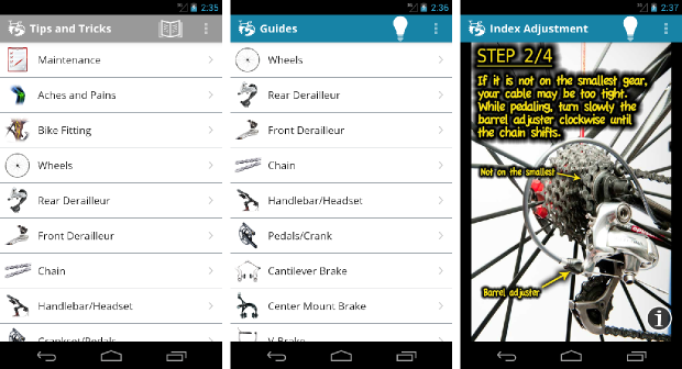
bikerepair_620

Platform: iOS

Price: 2.26€ / 3.20€

Website: www.bikerepairapp.com


Fill That Hole

Even if this app is only available in the UK, it had to be part of this list because it emphasizes the importance of public participation and collaboration for a better city. This app, developed by the National Cycling Charity, enables you to take photos of potholes (one of the worst enemies for a cyclist) and other hazards in the street, and uses the phone GPS location to send the info to the local authorities. A FixMyStreet for bicycles!

Platform: iOS, Android in development

Price: Free

Website: www.fillthathole.org.uk


RiderState

This app is a game that motivates you to ride your bicycle even more. In RiderState you’ll be conquering your street, neighborhood and city, based on how much and where you’re riding. The app will register your activity in real-time, and when you’re finished it will show a map of your conquered territory as well as stats of your game and ride, like the avoided CO2 emissions. Interesting take on mobility and gamification.

Platform: iOS Android

Price: free

Website: www.riderstate.com


Bike Tap

BikeTap was born from the effort to change the way people view cycling as part of their lifestyle, from recreational to social. It’s based on social interaction and basically you gain points and rewards by each trip you’re making by bike. You can challenge your friends for bike rides, arrange a meeting with them, know if they are going by bike or if the destination has parking infrastructures. Local businesses will be able notify users, and you can also know about trends in cycling. With this app you will find additional motivation through shared experience to get you cycling more often.

Platform: iOS (not lauched yet)

Price: Unknown

Website: www.vimeo.com/urbanfuturists


Kappo

While Kappo also means to encourage cycling by gaming, it is an interesting tool for institutions and governments as well. The concept is basically the same as the previous, everytime you ride your bike the app measures the time, speed and also weather and jumps. If it’s raining, for example, you’ll be getting more points to level up and more bikecoins to use on your profile. The graphics are very appealing and the game looks entertaining; you can compete with your friends, players from all around the world and also complete some very interesting challenging achievements.

Kappo achievements, profile and results pages

kappo achievements, profile and results pages

The most interesting part of Kappo is that, while it is a game for the users, it also provides data for the local authorities. They will get insights about local urban cyclists, being able to understand patterns and behavior, in order to act better towards their needs. A very interesting win-win model, with a (yet to be fully explored) potential around the ‘bikecoin’ concept.

Analytics1-Stgo

kappo cycling heatmap. from analytics page

Platform: iOS Android

Price: free

Website: www.kappo.bike


Bikestorming

The first thing we must say about this app concept is that the creator wants to make bike the most popular transportation mode by 2030. Bold statement! The second thing is that it’s all open-based. Bikestorming is (or will be) a collaborative platform intended to promote urban cycling everywhere.

Bikestorming-Screens-2

Different pages of bikestorming app

It’s designed to be fun and cool. Basically there is a Map and Missions. The Map shows more info available for urban cyclists than any other map, and the missions are a way to expand it. In other words, beside using the info of your city, you will also be posting about parking spots, safe streets or how do you integrate bike and public transport, among other missions. All the data is open to reuse.

full_Bikestorming_20PKNBA_2032_20english_20PNG_20OK.003

Platform: Soon to be on every smartphone and lightsaber

Price: Free

Website: www.bikestorming.org

Conclusion

Bikes have remained mostly the same during decades, but contemporary technology is slowly finding its way on everyone’s handlebar, with great potential. Apart of the visual aid and information that such apps can provide, there are also some interesting explorations of a sharing economy going on here. The mix of social coins, gamification, social interaction and crowdsourcing of urban data is a very promising one.

There are some limitations, though. For example, enabling your GPS (required for almost every biking app) while you ride may take you to your destination… and leave you with an empty battery.  As these applications get more popular, systems for in-bike charging will probably be popping up, as well as more and better ways to attach the phone to your bike.

This is just the beginning!

Comments: (0)

Datea: we are all “dateros” l Social Toolbox

Category: ⚐ EN+social toolbox

Screenshot of the homepage, datea.pe

Screenshot of the homepage, datea.pe

Website: www.datea.pe
Types: Platform
Topics: Urban issues in general | Mobility and accessibility | Public spaces


Datea, previously known as Todos somos dateros, is a public digital platform, which fosters citizens’ participation in the definition of problems and proposals for the improvement of Lima’s living conditions.

It is an independent project, developed by and from the civil society, and one of the first and more singular ones of its kind. It was born in 2010 thanks to a citizens’ initiative, and it was developed by the social enterprise La Factura in collaboration with Ciudad Nuestra.

The Datea project responds to the context of transformation that the city of Lima is living. Like many other capital cities Lima is facing urban transportation problems due to an excessive use of cars and unsustainable activities of informal transportation businesses, with consequent congestion and pollution. The platform applies relatively recent information technologies which, combined with campaigns in public spaces, create an innovative channel for participation. continue reading

Comments: (2)

Solving an intersection, the Dutch way | Where cars, bikes and pedestrians meet

Category: ⚐ EN+urbanism+video

How can urban design solve the complex situation that takes place in street junctions where bikes, pedestrians and motorists have to cross and turn in different directions? This interesting video shows one of the typical Dutch solutions to this problem.

Could this be implemented everywhere? While other places are going for mixed use of the street (like Spanish ciclocalles) or even more radical solutions like shared space or even ‘naked streets’ without any signs or lights, cities in the Netherlands are known for making extensive use of segregated bike lanes, and that is the scenario where this kind of solution makes sense. There are also other types of intersections, like the roundabouts, which can solve the same problem in a different way.

It’s worth noting how helpful the video format  is for explaining this kind of dynamic issues in the city. I also recommend reading the discussions under the posts linked below; you will find interesting opinions and alternatives.

Read more:

Original article at Bicycle Dutch
Via momentummag.com

Comments: (2)

Urban Mobility Master Plan – Lyon, France

Category: ⚐ EN+mobility+sustainability+the environment


Improving mobility for citizens
Citizens of Lyon will in future have better mobility, shorter tranportation time and be less dependent on private transportation. Lyon is the first French city to engage in a master plan for transport development. continue reading