Comments: (0)

Mapeo humanitario: Cómo ayudar al Ecuador después del terremoto

Category: ⚐ ES+cultura abierta+humanitarian architecture+tecnologías

MappingEcuador

Hoy compartimos con vosotros un artículo que nos ha resultado especialmente interesante por la actualidad del mismo, ya que trata del reciente terremoto en Ecuador, por su propuesta de uso de la tecnología como herramienta colaborativa y eficiente para coordinar acciones humanitarias en situaciones de emergencia, y por nuestro interés en Ecuador, un extraordinario país donde hemos tenido la oportunidad de trabajar en este último año

El artículo está firmado por Patricio Zambrano-Barragán y ha sido publicado previamente en los blogs del BID- Banco Interamericano de Desarrollo-, Ciudades Sostenibles y Urbe y Orbe

Han pasado ya unos días desde que un terremoto de 7.8 grados golpeó a ciudades y comunidades de la costa del Ecuador. Como respuesta, el gobierno y un sinnúmero de organizaciones de la sociedad civil lideran acciones de rescate y acción temprana en las zonas más afectadas. Una forma novedosa y efectiva de ayudar con el uso de la tecnología es el mapeo humanitario colaborativo.

Voluntarios expertos—médicos, enfermeros, psicólogos y psiquiatras—se han movilizado a las zonas más afectadas. A través de redes sociales y de canales oficiales, se han levantado varias campañas de donación de recursos para equipos de rescate, y de recolección de víveres, medicamentos y ropa para los damnificados.

Mientras, a la distancia, muchos nos preguntamos cómo podemos ayudar desde lejos.

Una opción concreta para cada uno de nosotros es el mapeo humanitario colaborativo. El objetivo es construir mapas base para organizaciones humanitarias y labores de rescate, con la ayuda de miles de voluntarios de todo el mundo. El mapeo humanitario jugó un rol de apoyo fundamental luego del terremoto de Haití (2010), y más recientemente en el terremoto de Nepal (2015).

En Ecuador, el Llactalab de la Universidad de Cuenca, en colaboración con la comunidad OpenStreetMap del país, está movilizando a voluntarios ‘digitales’ de todo el mundo para realizar un mapeo de áreas prioritarias, que hoy incluyen a las ciudades de Pedernales, Manta y Portoviejo, de acuerdo al Instituto Geográfico Militar.

Imagen del Instituto Geográfico Militar del Ecuador.


Este ejercicio puede ayudar con preguntas importantes para las labores de agencias gubernamentales claves como la Secretaría de Gestión de Riesgos (SGR), SENPLADES, y el Ministerio de Desarrollo Urbano y Vivienda. ¿Cuál es el estado de la infraestructura vial y qué rutas son utilizables? ¿Dónde se ubican las zonas con mayores daños a hogares y otras edificaciones? ¿Existen zonas de deslave? Esta información es a veces mucho más precisa que aquella disponible en plataformas como Google Maps, como se ve en los mapas de Pedernales generados en los últimos días.

En una primera fase, el mapeo se focaliza en la situación pre-terremoto: ubicar edificios e infraestructuras con base a imágenes previas al 16 de abril. Estos mapas se destinan principalmente a equipos de respuesta de la SGR y organizaciones como la Cruz Roja. A medida que se generan imágenes satelitales de la situación post-terremoto, el mapeo de las zonas afectadas permitirá identificar áreas de mayor prioridad, de acuerdo al nivel de daños y riesgo, y de mayor dificultad de acceso.

¿Cómo puedes convertirte en un mapeador humanitario? Acá tienes los pasos principales:

  1. Crear una cuenta en OpenStreetMap: haz click en openstreetmap.org y crea tu nueva cuenta de usuario. Date unos minutos para familiarizarte con la página y sus funcionalidades.
  2. Abre el gestor de tareas de mapeo (HOTOSM): dirígete a la página http://tasks.hotosm.org. Encontrarás una lista de todas las zonas por mapear; si tienes dificultad encontrando las tareas relacionadas al terremoto, simplemente ingresa ECUADOR en el buscador.
  3. Una vez seleccionada la tarea, haz zoom in, escoge uno de los cuadrados disponibles, y, haz click en ”comenzar a cartografiar”/“start mapping”. Luego escoge “editar con iD editor”/”edit with iD editor”
  4. iD editor en OpenStreetMap: dibuja polígonos encima de cada techo, y líneas para cada calle. Asegurate de ‘taggear’ cada polígono como “building” y de guardar tus cambios a menudo.
  5. Una vez que hayas terminado tu área, regresa a tasks.hotosm.org y selecciona la tarea como hecha.

Poco a poco, la comunidad de mapeadores está generando materiales didácticos para que todos podamos colaborar.

Imagen tomada con un dron después del terremoto en Nepal. 2015. Fuente: UAViators


Patricio Zambrano-Barragán es especialista en Desarrollo Urbano y Vivienda en el Banco Interamericano de Desarrollo (BID). Actualmente, trabaja en varios países de América Latina y el Caribe en temáticas relacionadas con planificación urbana y territorial. Previamente, se desempeñó como investigador en proyectos de infraestructura y gestión del territorio para el Massachusetts Institute of Technology y el Natural Resources Defense Council (NRDC). Patricio tiene experiencia tanto en el sector público como privado. Ha trabajado en el Departamento de Desarrollo de Vivienda de la Ciudad de Nueva York en programas de financiamiento de proyectos en riesgo; en la Alcaldía de Quito, Ecuador en sistemas de infraestructura urbana; y como consultor para empresas de energía y telecomunicaciones. Cuenta con una Maestría en Planificación Urbana y Regional del Massachusetts Institute of Technology y un Bachelor en ciencias políticas de la Universidad de Yale.
Comment: (1)

City Splash! for Copa Cagrana Neue | ecosistema urbano + transform.city proposal for Vienna

Category: ⚐ EN+architecture+city+ecosistema urbano+landscape+news+sustainability+technologies+urbanism


Last November we were selected, in collaboration with Transform.city, to participate in the Neue Copa Cagrana International shortlisted competition in Vienna (Austria). The scope of the competition was the urban revitalization and definition of the Master Plan in the area Neue Copa Cagrana defining an urban proposal and the relationship of this part of the city with the river.
We were selected along with other 8 teams, including renowned firms such as Dominique Perrault, AZPML, or West 8.

The context: Donau City, Vienna

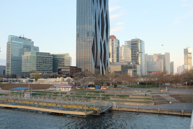
The study area is located next to Donau City, on the left bank of the new Danube Canal, Neue Donau, passing through the city of Vienna. It is a neighborhood of mainly tertiary character with office buildings of great height, developed in the last 20 years, including the Vienna International Centre.

Copa Cagrana – the intervention area, between the Danube and the new urban area with the D. Perrault’s tower

Despite the good connection with the city center, the large number of buildings and the excellent existing natural qualities, the area is almost deserted during day and night. This is mainly due to the lack of variety of uses, commercial facilities and recreational areas.
The proposal develops a series of strategies to revitalize an area that already has the optimal conditions to become a landmark for the city of Vienna:

FOUR OBJECTIVES

1 – Increase density and urban mixture

The proposal aims to incorporate urban, commercial and leisure life at a time when Vienna is starting to look for other forms of identity for the river area. It is important to bring new residents to help to create urban activity throughout day and night, summer and winter seasons by permanent and temporary uses. The mixed-use and residential functions in the first row, including the urban boulevard, have the potential to complete and complement the existing urban fabric and establish, for the first time, the necessary connections to make Donau City a functioning and exciting neighbourhood.

Activity diagram for the different seasons

The project proposes a high density urban prosthesis, combining housing, office, commercial and public space, in order to create an active urban spot connected to the surrounding, improving its identity and multiplying the possibilities of use.
The proposal seeks to make Donau City easier to be understood and perceived, with a clear connection to Danube river and its waterfront. Therefore, the proposal is the missing link to the completion of the Donaustadt and is, at the same time, the necessary catalyst to enable the urban regeneration in the area.

2 – Create new urban spots

Copa Cagrana will be an exciting new urban spot in Wien, which is perfectly connected to the city network thanks to the transport connectivity and subway line. Through the physical proximity with existing Donau City, Donau Insel and surrounding neighborhoods, the area will increase popularity and will offer more attractions to the users.
The newly created waterfront will be an urban catalyser with a variety of urban functions, with uses according to the seasons and day and night time:
The FILTER ZONE is a more quiet area free of commercial activities.
The TEMPORARY ZONE changes according the different seasons, with beach bars in the summer, pop-up restaurants, terraces and platforms, etc.
The WATERFRONT is an enjoyable walkable strip with piers and exciting water activities for summer and winter.

The FILTER ZONE

3 – Renaturing (urban+nature landscape)

A new urban and natural environment intrinsically connected with surrounding nature.
It will be the connecting environment between Donauinsel and Donau Park but also extending its limits over the water landscape of Neue Donau to create a vibrant and diverse waterscape.


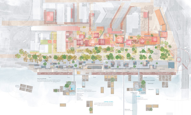
Masterplan 1:1000

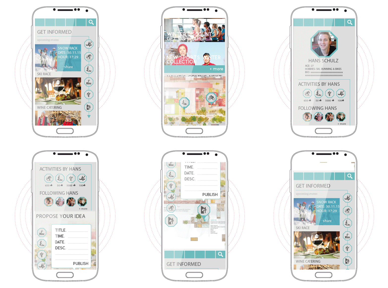
4 – Digital Identity – web app strategy

It is important to create the communication channels in order to advertise and share information about the ongoing activities and as a way to share potential ideas to be implemented. This web APP is thought to work as a social network that provides information for the citizens of Copa Cagrana on what kind of activities they can do on this renewed urban area.
Users will be able to register and create a user profile, with this, they will have the opportunity of proposing activities that will make use of the beautiful surroundings and installations of this urban space. The commercial sector will also have their own space. They will have the possibility of creating a profile which will allow them to publicize their products and business, as well as invite and inform citizens about special deals, offers, events and other celebrations.


FIVE NEW URBAN ZONES

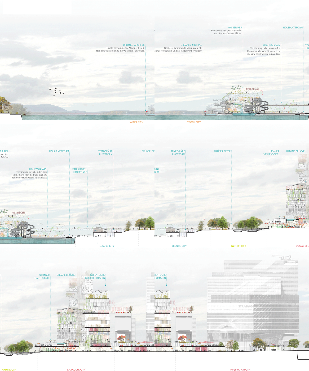
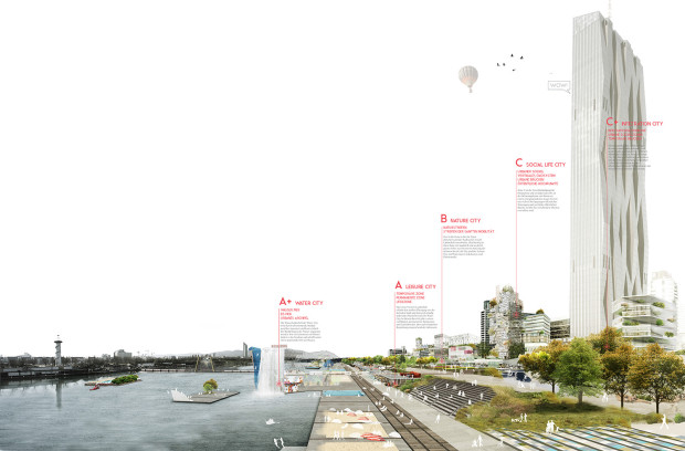
Cross Section

Seeking to achieve these four objectives, the proposal creates 5 zones acting together and related to each other:

Zone C+: Infiltration city

The energy of city life will splash towards Donau City and the urban plinth will extend its limits to bring activity and reconfigure the public spaces around the corporative and residential buildings. These urban tentacles will extend urban plinth limits with linear and small scale pavilions, pop-up stores and cafes, etc. reconnecting and renewing the pedestrian pathways of the Donau city.

Elevation

Zone C: Social life city

Zone C proposal is the most powerful urban energy boost, as it provides a large amount of overlapped new programs and public spaces easily accessible at different levels.
Areas:
Urban plinth: fragmented construction from 1 to 4 stories high, multiple programs with predominance of commercial spaces overlapped with public spaces at different levels.
Vertical ecosystems: housing towers with a myriad of different typologies to create a diverse neighbourhood. The housing units help to create a dense neighbourhood with urban life throughout the day.
Urban bridge: On the tenth floor, same level as the top terrace of the existing linear building of social housing, a bridge is creating connections between semi public spaces, with diverse programs within the vertical ecosystems.
Public peaks: the top floor of the different towers is also part of the network of semi public spaces within the vertical ecosystems. These spaces can hold multiple programs and part of their success will be the privileged point of view of the city (terraces, cafes, common spaces,… )

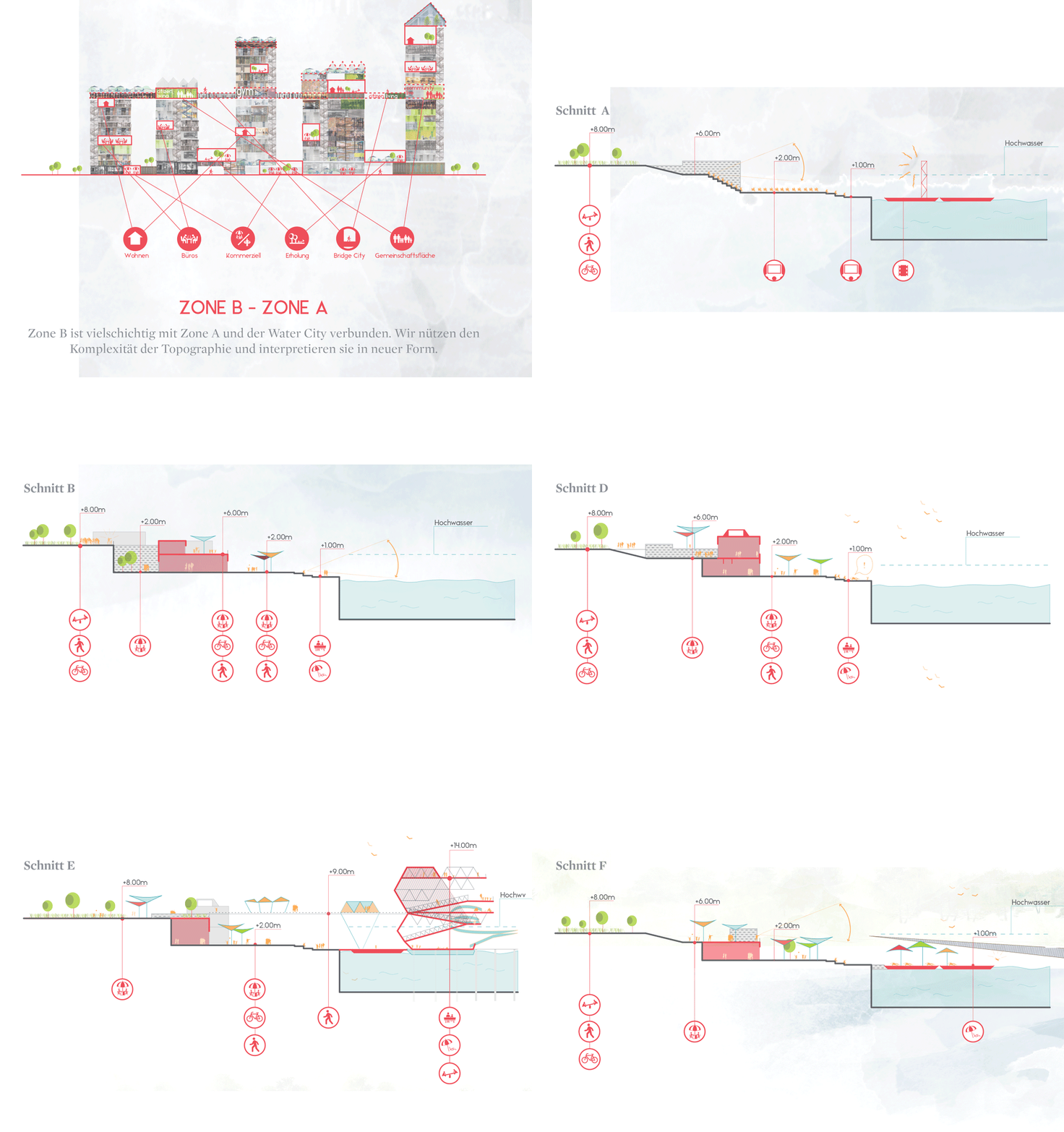
Zone B: nature city

This is a zone where nature is predominant and the urban plinth is melting its limits with the landscape. At the same time, the natural character of this area helps to make the transition between the bigger, urban scale of zone C and both the lower scale of zone B and the waterscape towards Donauinsel, combining natural areas with paths for soft mobility.

Different cross sections in zones A and B

Zone A: Leisure city

Leisure cityscape to allow the transition between the formal city and the vibrant and ever changing new waterscape of zone C+. It will hold multiple permanent uses but also temporary programs and seasonal activities. There are multiple temporary and permanent uses in small buildings with similar language, as well as a new riverside walk that will extend to create a comfortable linear space. The relationship with water and the elevation difference will be resolved with a wooden platform that will act as an urban sofa to relax and enjoy the presence and proximity of the river.

Zone A+: Water city

Vibrant and ever changing waterscape in continuous evolution. It will extend the activities of the new urban spot towards the water.

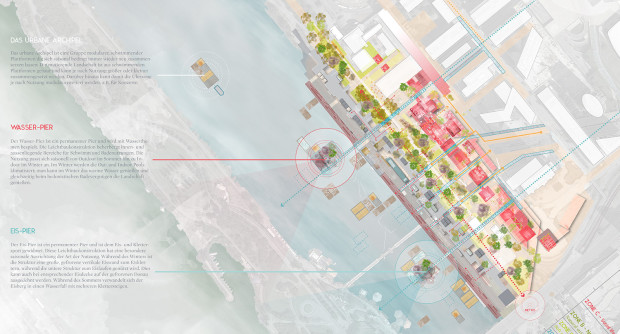
Masterplan 1:2000

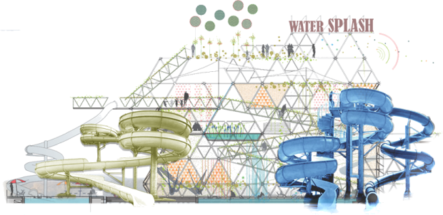
+ water pier: permanent pier, water thematic. Light structure with indoor and outdoor spaces to allow the creation of different bathing experiences. The use will change seasonally, during the winter, outdoor and indoor climatized pools will allow the user to be in connection with the surrounding natural landscape while having a pleasant bathing experience.

The water pier for summer activities

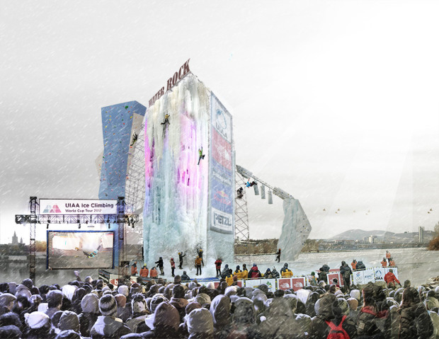
+ ice pier: permanent pier, ice and climbing sports oriented. Light structure with a strong seasonal connection. During the winter, part of the structure will be a huge frozen and faceted vertical surface to practice ice climbing, while the lower platform will host different ice skating outdoor rinks to practice in connection with the water and natural landscape. During the summer the ice surface is transformed into a huge waterfall falling from the upper level into the river.

ice pier_con nieve

The ice pier for winter climbing

+The urban archipelago: big modular and floating ever changing extension of the waterfront. The different seasons and uses will dramatically transform its configuration. This mutant landscape is built with modular floating platforms/barges that can be combined to create larger flat surfaces if necessary. These platforms can be connected to the limit line of the waterfront to extend its surface.

If you want to know more about the proposals you can download the competition panels here:
Panel 1   Panel 2   Panel 3   Panel 4

Comments: (0)

call for projects eme3 2016_”contingencia y praxis”

Category: ⚐ ES+arquitectura+concursos+convocatorias+creatividad

callforweb-EME3_2016-1100x574

También este año difundimos la llamada a proyecto que nos llega desde eme3, festival internacional de arquitectura que surge en 1999 como respuesta a la necesidad de encontrar un espacio para arquitectos, urbanistas y artistas de diferentes disciplinas, en el que poder encontrarse y presentar proyectos innovadores, poco convencionales y que escapan de las tendencias comunes en la construcción y/o planificación urbana.

Este año el festival eme3 tendrá como temática la arquitectura de emergencia, construcciones de rápido montaje y desmontaje, que puedan paliar las densas aglomeraciones de refugiados en diferentes regiones del planeta y bajo diversas circunstancias. Teniendo como parámetros la innovación, la economía de recursos tanto en el aspecto constructivo como en el uso responsable de nuevas tecnologías y materiales. Siempre bajo la consigna de adaptabilidad al contexto y medio en el que se esté trabajando.

Para esta edición se plantea un ejercicio a escala real de un campamento de refugiados en el campus ETSAV (Escola Técnica Superior d’ Arquitectura del Vallès). Donde se instalarán prototipos diseñados y construidos por los participantes, quienes deberán utilizarlos como habitares durante los días del evento (30/junio-3/julio). En noviembre se organizará en el COAC (Col.legi d’ Arquitectes de Catalunya) una exposición que muestre tanto los procesos como los resultados de la experiencia.

Más informaciones sobre la call y la ficha de inscripción están disponibles a este link en español, en catalá, y en inglés.

Comment: (1)

El blog de Arquia busca corresponsales

Category: ⚐ ES+convocatorias

foto_portada_654

El blog de la Fundación Arquia está buscando para este 2016 a nuevos colaboradores que quieran contribuir al desarrollo de contenidos con los breves artículos que ya son su seña de identidad. La temática de los posts es libre—cada autor tiene que presentar sus propuestas— siempre que encaje en alguna de las líneas editoriales del blog:

  • Profesión:Formación, futuro, organización y gestión, competencias, concurso
  • Arquitecto y sociedad: Participación ciudadana, compromiso social, educación
  • Pensamiento y crítica: Publicaciones, investigación, crítica de la arquitectura

Cada corresponsal podrá publicar hasta 4 posts al año, de unas 500 palabras cada uno, y los honorarios son de 100€ por post publicado.

El plazo para presentarse termina pasado mañana, el 8 de abril de 2016.

Ver las bases e información de la convocatoria

El blog surgió con el objetivo inicial de proporcionar un lugar de debate, pensamiento y crítica sobre las inquietudes actuales de la profesión y encuentro on-line de los jóvenes arquitectos, un punto de encuentro para toda la profesión, una plaza digital o ágora 2.0.