Comments: (2)

Mapdwell Solar System | Mapeando el potencial solar con una precisión sin precedentes

Category: ⚐ ES+sostenibilidad+tecnologías+urbanismo

Solar System muestra el potencial solar a alta resolución

Un proyecto llamado Mapdwell, desarrollado por un equipo del MIT, ha dado como resultado el software Solar System, que permite visualizar el potencial solar de las cubiertas de los edificios con la mayor resolución lograda hasta la fecha en un sistema de este tipo.

El proyecto Mapdwell

Fruto del desarrollo por un equipo de académicos e investigadores del Building Technology Sustainable Design Lab del MIT (Massachusetts Institute of Technology) y con una licencia concedida a Mapdwell LLC, el Proyecto Mapdwell busca dotar a las comunidades con información que promueva prácticas sostenibles, conciencia comunitaria, eficiencia energética y desarrollo inteligente a través del esfuerzo colectivo. Al transformar información abierta, precisa e imparcial en educación y acción, propone una solución orgánica al problema de los combustibles fósiles.

Las decisiones individuales sobre dónde y cómo vivir tienen el potencial de impulsar la sostenibilidad. Sin embargo, los ciudadanos carecen en general de las herramientas para decidir informadamente. Por ello, el equipo de Mapdwell trabaja en la intersección de los datos, el diseño y la tecnología para crear instrumentos innovadores e intuitivos de análisis, evaluación y visualización –a nivel de unidad y de contexto– para sistemas y regiones urbanas y no urbanas.

¿Cómo funciona Solar System?

La herramienta Solar System utiliza datos LiDAR (Light Detection and Ranging) de alta resolución (una retícula de 1×1 m) para crear un modelo tridimensional del terreno que tiene en cuenta la forma de las cubiertas y otras estructuras, la infraestructura existente y la densidad de las copas de los árboles.

Proceso de obtención y elaboración de los datos

Proceso de obtención y elaboración de los datos – Clic para ampliar

Este modelo se usa a continuación para evaluar la cantidad de radiación solar que recibe cada unidad de superficie para cada hora del año y evaluar con ello el potencial individual para la generación eléctrica solar usando paneles fotovoltaicos.

La aplicación online toma esos datos de potencial fotovoltaico y los superpone sobre la imagen satélite de Google, acompañados de una interfaz que permite al usuario consultar y entender los datos visualizados.

Captura de la interfaz de la aplicación Solar System

Captura de la interfaz de la aplicación Solar System – Clic para ampliar

Seleccionando un edificio del mapa nos muestra en un panel lateral una serie de datos sobre su cubierta, incluyendo el tamaño del sistema en kilowatios, el coste previsto para el propietario (incluyendo deducciones e incentivos locales), la compensación de carbono y los ingresos anuales previstos, según la extensión de la instalación que puede regularse con un control deslizante. Todos estos datos se presentan de forma sintética y clara con el fin de ayudar al usuario a tomar decisiones respecto a la instalación de paneles fotovoltaicos.

El panel nos permite alternar entre cuatro grupos de datos: Dinero, inversión, técnico y medioambiente.

El panel nos permite alternar entre cuatro grupos de datos: Dinero, inversión, técnico y medioambiente – Clic para ampliar

Lo llamativo de esta aplicación es que los algoritmos empleados logran unos de los resultados más detallados y precisos hasta la fecha. Otros mapas solares similares asumen, simplificadamente, que todas las cubiertas son planas o que el ratio entre radiación directa y difusa es constante a lo largo de todo el año. Solar System pondera esos parámetros de una forma más precisa, logrando que sus predicciones varíen solamente entre un 4% y un 10% sobre los datos de medición reales.

Actualmente la predicción de rendimientos es bastante conservadora, ya que considera los paneles apoyados en el mismo plano de la cubierta, cuando la mayoría de las instalaciones permitirían situarlos en un ángulo mucho más adecuado según la latitud.

Implantación

Aunque la aplicación actualmente sólo tiene datos disponibles para Cambridge y Washington DC, su interfaz está traducida al español y sus creadores invitan a ciudadanos y potenciales patrocinadores a proponer nuevas ubicaciones: “Únete al esfuerzo de traer Mapdwell Solar System a tu comunidad. Saber dónde estás nos ayuda a saber a dónde tenemos que ir”.

Mapa de ubicaciones - Clic para ampliar

Mapa de ubicaciones – Clic para ampliar

Links relacionados:

Mapdwell Solar System: es.mapdwell.com
Sustainable Design Lab @ MIT: web.mit.edu/sustainabledesignlab
Visto en Gizmag

Comments: (2)

Guidelines to build participatory and inclusive societies

Category: ⚐ EN+architecture+art+city+creativity+placemaking+research+sustainability

portada_654x254

In order to achieve the Post-Master called Urban Research Lab Sardinia – Environmental Design at the Università di Sassari (DAP), in partnership with the Dessau Institute of Architecture (DIA) of Anhalt University of Applied Sciences, an article will be published about the project made during the italian period, under the supervision of Ecosistema Urbano: Punto d’incontro.

This is an excerpt of the introduction, including some references and case studies.

The role of the architect

The role of the architect has always been, throughout ancient and modern history, a reference point for the city growth and development. Nowadays, this figure is undergoing a massive transformation, which cannot ignore social aspects. The modern architect helps to integrate production processes within the spaces users live and use in everyday life.

The article aims to present an experiment that was personally led in a very specific local community in Sardinia (Italy) which is affected by logistic, economical and management problems. Through theoretical studies and personal analysis of a variety of existing projects, a detailed process was drafted in order to suggest a strategic action plan.

Western society has scarce resources and the European architect often asks the following question, what can I do now without nothing? In this hard times, it is far more difficult for closed solution to be imposed by a power minority than for specific temporary actions to be applied based on grassroots talks, because sensitivity is high and social groups are highly resistant to accepting any changes which have not come from within their ranks. Ecosistema Urbano (2011). “Negotiating at all level”. A + T 38. 120

fountainhead_654

Strategy & Tactics

The first input to the change came with the drafting of Agenda 21, a voluntarily implemented action plan of the United Nations with regard to sustainable development. It emphasises that broad public participation in decision making is a fundamental prerequisite for achieving sustainable development. The main goal is trying to involve the local communities in the construction process of the future of the cities. When public space is concerned, there are two ways to run over: strategy and tactics. Both are tools of equal value, but with different typology of method; they are usually known as top-down or bottom-up processes.

Tactics are actions which take place on enemy territory while strategy is always enacted on home ground. Which can lead to an immediate run-of-the-mill sharing out of roles: strategy is an instrument of power, tactics are used by citizens; strategy occupies space, tactics play out in time; strategy is used to control, tactics to protest. De Certeau, M.(1988). The Practice of Everyday Life. University of California Press

Recent developments of these concepts became well known under different name, but in essence they are all the same.

Tactical urbanism. It is defined as small-scale improvements in an effort to effect large-scale, long-term change.
Placemaking. It is the act of enlivening public spaces and places for the betterment of the community and its neighbors.
Participatory design. It is an approach to the assessment, design, and development of technological and organizational systems that places a premium on the active involvement of workplace practitioners (usually potential or current users of the system).

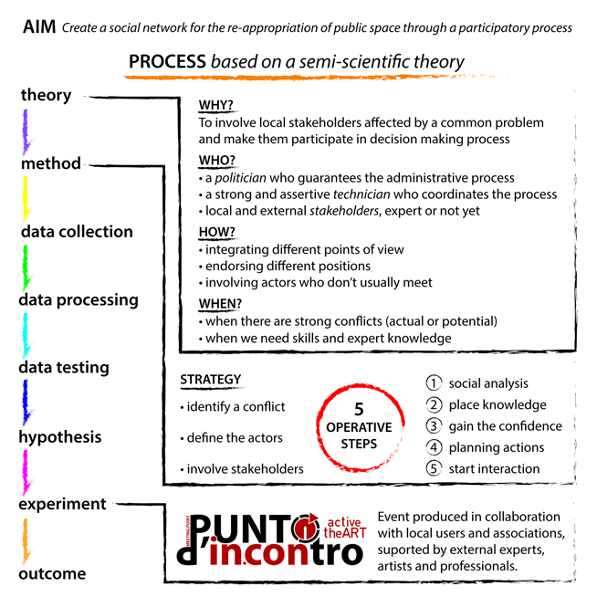
The following scheme represents the stages of the experiment:
Process_654

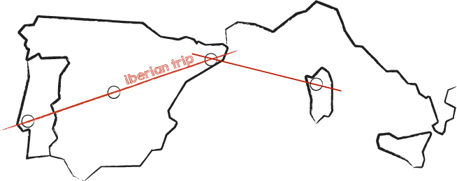
The Iberian trip

There was the necessity to analyze the theory, exploring some case studies and finding some references. This processes are already very disseminated all over the world, especially in USA and north Europe, where the citizens have a great sense of community and cooperation.

Nevertheless this research focused on the Mediterranean area, in this particular case in the Iberian peninsula, where the lack of organization meets high quality and creativity, typical of the Latin culture. Some of the cases shown here are real established structures, others are spaces under construction and constantly changing. The connecting link is always one of active participation.
iberian trip_654

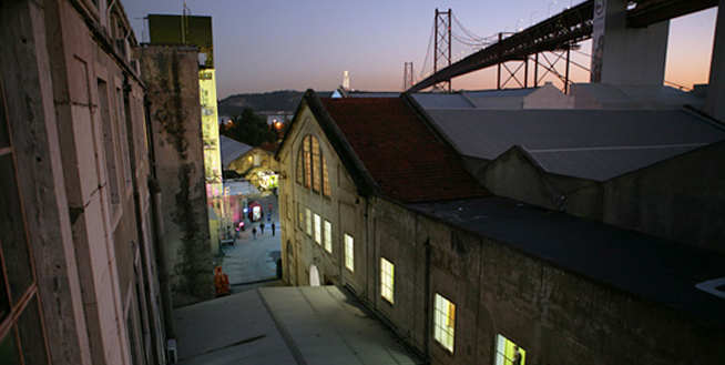
LXFACTORY – Lisbon

An urban fragment, kept hidden for years, is now returned to the city in the form of LXFactory. A creative island occupied by corporations and professionals of the industry serves also has stage for a diverse set of happenings related to fashion, publicity, communication, fine arts, architecture, music, etc.

lx_factory

El campo de cebada – Madrid

A group of neighbours called Distrito Centro promoted a temporary use of the vacant lof of a former public pool demolished in a district of Madrid, during the time in which the work planned for urban reuse was not to be carried out. The intention is that the space will accommodate all types of proposals/activities/projects (cultural, social, artistic, sport) for the use and enjoyment of the people of the district and all the city.

cebada

Matadero – Madrid

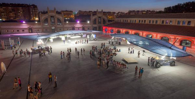
The old slaughterhouse and livestock market, where Matadero Madrid is now located, was built according with the project of the architect Luis Bellido. The site was architecturally transformed.
Matadero Madrid’s mission is to promote creation in all its forms and expressions. With special attention to cross-sectorial propositions, it focuses on three main action areas: training, production and dissemination.

matadero

Fabra i Coats Creation Factory – Barcelona

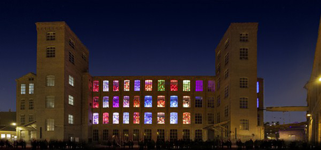
Fabra i Coats is a multidisciplinary space which will be promoting artistic hybridisation to become a point of reference in artistic research and in the generation of new quality contents, as well as a meeting point for groups, creators and proposals from different spheres and backgrounds.
The goal is to give support to artistic creation and it has workspaces for the performing arts, music, plastic and visual arts, multimedia creation and also for projects related to information and communication technology.

fabra i coats

Sometimes these kind of actions are not supported by a physical space, but by the people that build their spaces through some collective iniziatives, occasionally supported by a politician organization or made by self-funded artistic groups.

Urbact

It is a European exchange and learning programme promoting sustainable urban development. They enable cities to work together to develop solutions to major urban challenges, reaffirming the key role they play in facing increasingly complex societal changes. URBACT spans over 500 cities, 29 countries and 7,000 active participants.

urbact

Collectif ETC

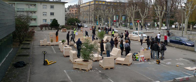
Born in Strasbourg in 2009, this collective gathered energy around a common dynamic questioning of urban space. Through different means and different skills it wants to be a medium for experimentation. They believe that the different users of the city (residents and professionals) can all be involved in its development to a wide range of scales. The purpose and importance of these urban experiments is not only the result but also the process that generates it, as well as the new environment and new behavior it generates.

colletif etc

Boa Mistura

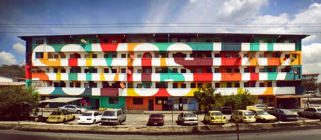
It is an urban art group formed at the end of 2001 in Madrid, Spain. Its members have diversity of perspectives, distinct visions which complement each other, and combine to create something unique and coherent.

boa mistura

Madrid Street Art Project

It is a noprofit association that through the organization of various activities and initiatives (urban Safaris, workshops, lectures, recovery rooms) aims to contribute to these reflections, to encourage citizens to enjoy urban art, contribute to its dissemination and support its creators.

madrid street art project

Conclusions

The final article will aim to give some semi-scientific guidelines to build participatory and inclusive societies. The new frontier of the architect should be to drive local communities in the management of public and private space, involving them in the construction process of the urban renewal. This is when the architect, as a highly knowledgeable technician, plays an essential role to mend the relation between politicians and common people.

02_654

Comments: (0)

Ciudades latentes, mundos posibles | Concurso de relato breve Ábrete Séneca + Vibok Works

Category: ⚐ ES+ciudad+concursos

Ábrete Séneca - Ciudades latentes, mundos posibles

Existen tantas ciudades como miradas subjetivas se posan sobre ellas.

El estudio creativo Vibok Works en colaboración con el colectivo ciudadano Ábrete Séneca convocan el Concurso de Relatos Breves “Ciudades Latentes, Mundos posibles”.

Esta iniciativa se enmarca dentro de lo que desde Vibok Works llaman una “acción editorial“. Dentro de la serie Re—write this book, cada título reúne 1 experiencia + 1 ensayo + 1 acción, que en este caso describen como “Call for Short Stories” y que en publicaciones anteriores ha tomado la forma de “Feedback-photo Calls”, “Loud Thoughts”, “Editorial Picnics” y “Call for Pics”…

El objetivo en esta ocasión es fomentar, a través de la edición de un libro, la reflexión sobre el aprovechamiento y disfrute ciudadano, real y posible, de los espacios de la ciudad. Esta reflexión fue iniciada por dicho colectivo en la Plaza Séneca en Alicante, un espacio potencialmente disponible pero en la práctica inaccesible.

El propósito del concurso es recoger tanto experiencias como visiones inéditas y divergentes sobre los ESPACIOS COMPARTIDOS en la ciudad en la forma de relatos breves. Se buscan historias reales o imaginadas, vividas o soñadas, utópicas o distópicas. Todos los géneros, desde el misterio a la ciencia ficción son bienvenidos. Una selección de los trabajos recibidos será incluida en el libro “Abrete Séneca” cuya publicación está prevista para diciembre de 2013.

Cartel del concurso: Ciudades latentes, mundos posibles


Como nos comentaban Martín Noguerol y Raúl Dolz, de Ábrete Séneca:

El estudio Vibok works nos presentó una propuesta editorial muy interesante a través de crowdfunding en la que contar la experiencia en Alicante a través de los espacios que nos hemos ido encontrando: Un solar es un espacio muy diferente si lo comparamos con el despacho de todos los concejales y alcaldesa que hemos tenido que pisar para presentar el proyecto y llevarlo adelante. Nos interesa también la visión no-arquitectónica sobre el espacio público, y hemos decidido hacer un concurso, donde los cinco seleccionados se publicarán y se mezclarán con nuestra mirada.

Para aquellos que le deis al teclado tanto como al ratón, es una buena oportunidad para recordar, reflexionar e imaginar esos espacios urbanos compartidos, ya sea desde vuestras experiencias o vuestras más locas fantasías.

El premio, la publicación del relato, un lector de libros electrónicos… y una paleta de jamón.

Plazo: 15 de noviembre de 2013, a las 23.59 horas (segundo arriba, segundo abajo).
Objeto: Relatos de 600 a 1200 palabras, en castellano.
Bases: abreteseneca.tumblr.comvibokworks.com

Comments: (0)

Maushaus | eu:KIDS

Category: ⚐ ES+eu:kids+Uncategorized

Maushaus-01

Maushaus (San Sebastián), es la casa de los ratones y está dirigida por Carlos Arruti y Anabel Varona. Organizan cursos, talleres, exposiciones y todo lo que se les ocurra para enseñar a los “muy jóvenes” de forma divertida y lúdica los entresijos de la ciudad, el espacio y la arquitectura. leer más