Starting July 3rd, Jose Luis Vallejo and Belinda Tato from ecosistema urbano will be joining more than 20 teachers and 40 studens in an International Summer School organized in the valley of Solanas (Sardinia) by Department of Architecture, Design and Urban Planning at the University of Sassari in collaboration with the Municipality of Sinnai.
The objective of the Summer school is to develop new forms of architecture, particularly related to tourism, in the valley of Solanas and in the coastal area in the south-eastern part of Sardinia. The development of new forms of architecture in coastal areas requires alternative approaches to the traditional scenarios of seasonal tourism. Teachers, students and public servants will be working together to face challenges related to the economically instable and unfavourable conditions created by seasonal tourism. The environmental contexts studied are sensitive and fragile, yet, at the same time, they are sites of great potential for developing innovative solutions and new uses. The activities of the workshop will aim at enhancing this potential by using the specific qualities and resources of the various contexts presented in the area.
If you are studying in Europe, you will get a special deal: Students coming from European universities only have to pay 50 euros for fee + 100 euros for 10 days for lodging + travel (there are cheap low cost flights to Cagliari).
And you’ll get to spend those 10 days learning, collaborating, walking and bathing in front of this great landscape… so don’t think for too long, registration is closing in 10 days!
Important information:
Registration is closing on June 15th! Edit: June 20th.
Save the dates: July 3rd – July 13th
Cost for European students: 50 € fee + 100 € for 10 days lodging
Learn more about this experience: coastal-landscape-architectures.blogspot.it
So far, 14 international – from quite diverse places like the US, Ucrania, Lebanon or South Corea – and 8 local students have already registered, and the University of Alicante just extended the registration period over June, so you still have a chance to join!
Sustainability is not just an environmental issue but, and above all, a social, cultural and economic one. This course about URBAN DESIGN and SUSTAINABLE ARCHITECTURE proposes a complex incursion within the subject of sustainability understood not only as a problem but as an opportunity to meet new approaches to the city in a creative, innovative, playful and unprejudiced way.
Sustainability in an international environment: Experts in sustainability, teaching and design from all around the world meet in Alicante. Learning by the sea: Meet friends from all around the world and enjoy the Mediterranean culture, a different way of understanding architecture, the city and life. Challenging yourself: A fresh and playful approach to sustainable design. Finding your way: We offer a wide variety of thematic contents as well as plenty of activities for your free time.
We will be taking part with PLAYstudio – the organizers –, Transsolar and Urban Think Tank. Looking forward to meet you there!
I would like to share with you my personal experience in a ‘Design-Analyse-Build’ way of design. Some of you might think, that it sounds not so innovative and most of the architects work in that way, that’s probably could be the truth, BUT there are some specific tips that make this experience unique.
In this post I will refer to the workshop that I shared in IED Torino Master SUS with the main coordinators ARCò and MCArchitects studio, about designing an off-grid sustainable school for Palestine, Gaza_Rafah.
Firstly, I want to meet you with a work plan, that we were followed:
1. Climate analysis of an area
2. Analysis of the state conditions and local features of the area
3. Understanding the type of users and their needs
4. Environmental strategies selection
5. Concept creation
6. Design process
7. Shadow, daylight and glare analysis using Ecotect
8. Model 1:1 scale prototype
The first step was to analyse the climate of the area to understand the possible environmental strategies we can use and make a list of parameters that is better to avoid or conversely exploit during design process. The most tricky stuff was to find the weather data for Palestine, because nowadays all the information about it is classified, due to the war. Finally we had to use weather data of Beer Sheeva that located nearby in territory of Egypt.
The result of a Climate analysis using
During most of the year temperature is above the comfort zone.. The winter is short, but is noticed with a humid winds. The summer period lasts almost 7 months and accompanied with high temperature of the air and wind.The difference between the highest and lowest temperature during the day is about 10°.With this climate is important to orient building to protect it from the direct sun during summer and to capture it during winter. Also the building should be covered from strong winter wind,but use the summer ones.
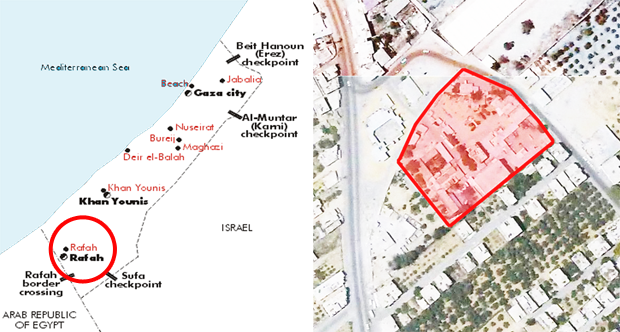
The second step was to find out the location of Rafah city and underline the main function of that place. One of the most important thing was to see the actual state of the construction site, that was almost impossible due to the hostilities.
Site location. Palestine. GazaStrip, Rafah
Rafah is situated in the southern part of the GazaStrip in Palestine, at the border with Egypt. According to the peace treaty between Egypt and Israel at Camp in 1982, Rafah was divided into two parts. One part was assigned to Egypt, the other part to the Gaza Strip. Nowadays Rafah is the only point of importance in the country.
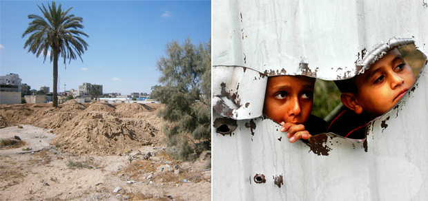
The third step was to ‘meet’ the users. In this case we had to try being in their shoes, imagining lifestyle of a kid who was born and had been living all of his life in a war situation, always surrounded with fences and swaying wire in a lack of green safety spaces and entertainments.
The site is located in the central empty area of Rafah. It is surrounded with residential houses and a big warehouse.In the real-time the site is full of excavated earth, because of the erasion of the previous construction, after the bombing.
From 1948 the population of Palestine live in the war situation.. So the country has problems in many different fields, one of it belongs to children and it is lack of schools and areas for children activities
The fourth step was to choose the environmental strategies to follow to reach the off-grid building. This phase is strongly related to the climate analysis. In this case, is very helpful to see the vernacular architecture of a place to choose the right strategies.
The fifth step is a sort of summary of all the strategies we chose for the building – concept creation. Concept is the phase right before the design process, so it was important to choose the right orientation, shape, functional zones etc. We were also advice to make a simple symbol or logo that would describe our project in few seconds, that finally could become sort of a brend.
‘The Earth is our school, so let’s make the school with earth!’
One of the most important steps was analysis of the building with Ecotect, Autodesk 2011. For this project we had to make several calculations, such as: solar, shadow, daylight and glare analysis.
Usually shadow analysis is calculated for the longest and shortest day in the year, such as 21st of December and 21st of June. In this case we also did computings for 21st of march to get proper results and see if the overhangs are useful during al the year.
Solar analysis shows us the amount of sun hours that building surfaces receive during the day. It gives us the idea of facade protection from the direct sun. It also could be very useful to see the best position for the PV panels to let them produce the maximum energy.
Daylight factor analysis is the ratio of internal light level to external light level.A low asks for classrooms a 5% daylight factor. For art, craft, technological laboratories thatratio is even higher. Daylight can be used to offset the need for artificial lighting and hence reduce dependency and consumption on electricity and the greenhouse gas emitted. Effective daylight distribution must be achieved in a manner that brings visual satisfaction to the occupants.
Glare analysis is a calculation about number of direct sun or reflection coming from a very bright source outside the field of view. The reflection may cause discomfort as well as the additional annoyance of veiling or masking out the information which is being sought within that view.The result of analysis using
The final step was a model in 1:1 scale that we built-in one of the parks in Turin city. It was a great chance to ‘feel’ the construction and understand the weak and strong points of it. In my personal opinion, it was one the best parts of design, when you make the proof to your ideas and drawings, so you can be sure that the techniques you had chosen is stable and can answer to your expectations.
The water footprint of an individual, community or business is defined as the total volume of freshwater that is used to produce the goods and services consumed by the individual or community or produced by the business.
The water footprint consists of three components: the blue, green and grey water footprint. The blue water footprint is the volume of freshwater evaporated from the global blue water resources (surface water and ground water) to produce the goods and services consumed by the individual or community. The green water footprint is the volume of water evaporated from the global green water resources (rainwater stored in the soil as soil moisture). The grey water footprint is the volume of polluted water that associates with the production of all goods and services for the individual or community. The latter can be estimated as the volume of water that is required to dilute pollutants to such an extent that the quality of the water remains at or above agreed water quality standards.
The past century has brought a lot of changes, like the explosion of human population, the creation of an expansive global economy and the increasing technological development. All of them have put unprecedented pressures on water. More specifically, our growing appetite for water-intensive food and manufactured good, the construction of large dams for hydro-electricity and irrigation, and the massive discharge of industrial waste into limited freshwater sources, have made water an increasingly limited and expensive resource.
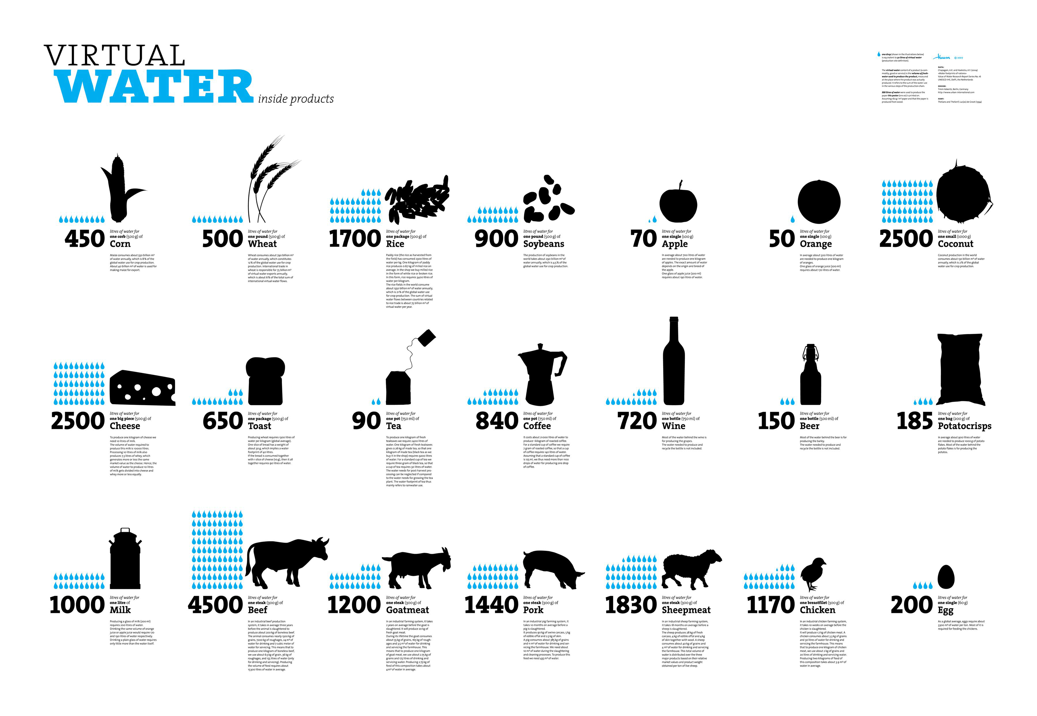
Despite this obvious fact, people use large amounts of water: drinking, cooking and washing, but even more for producing things such as food, paper, cotton clothes, and almost every other physical product. This water can be named as virtual water.
The virtual water content of a product (a commodity, good or service) is the volume of freshwater used to produce the product, measured at the place where the product was actually produced.
It refers to the sum of the water use in the various steps of the production chain. The virtual-water content of a product can also be defined as the volume of water that would have been required to produce the product at the place where the product is consumed (consumption-site definition).
Water footprints can be hard to calculate, depending on how far up the chain of production you go, since everything you eat and buy used some water to produce. With our latest Transparency, I give you some examples of how much water is used in some of your daily activities, so that you can begin calculate your footprint and try to reduce your gallons.
To help put things in perspective, think about this: your standard trash barrel holds 32 gallons and a mid-sized passenger car-if pumped full of water has room for a little more than 800 gallons. So, the difference in the amount of water it takes to produce a pound of chicken and a pound of beef is enough to fill almost two whole cars.
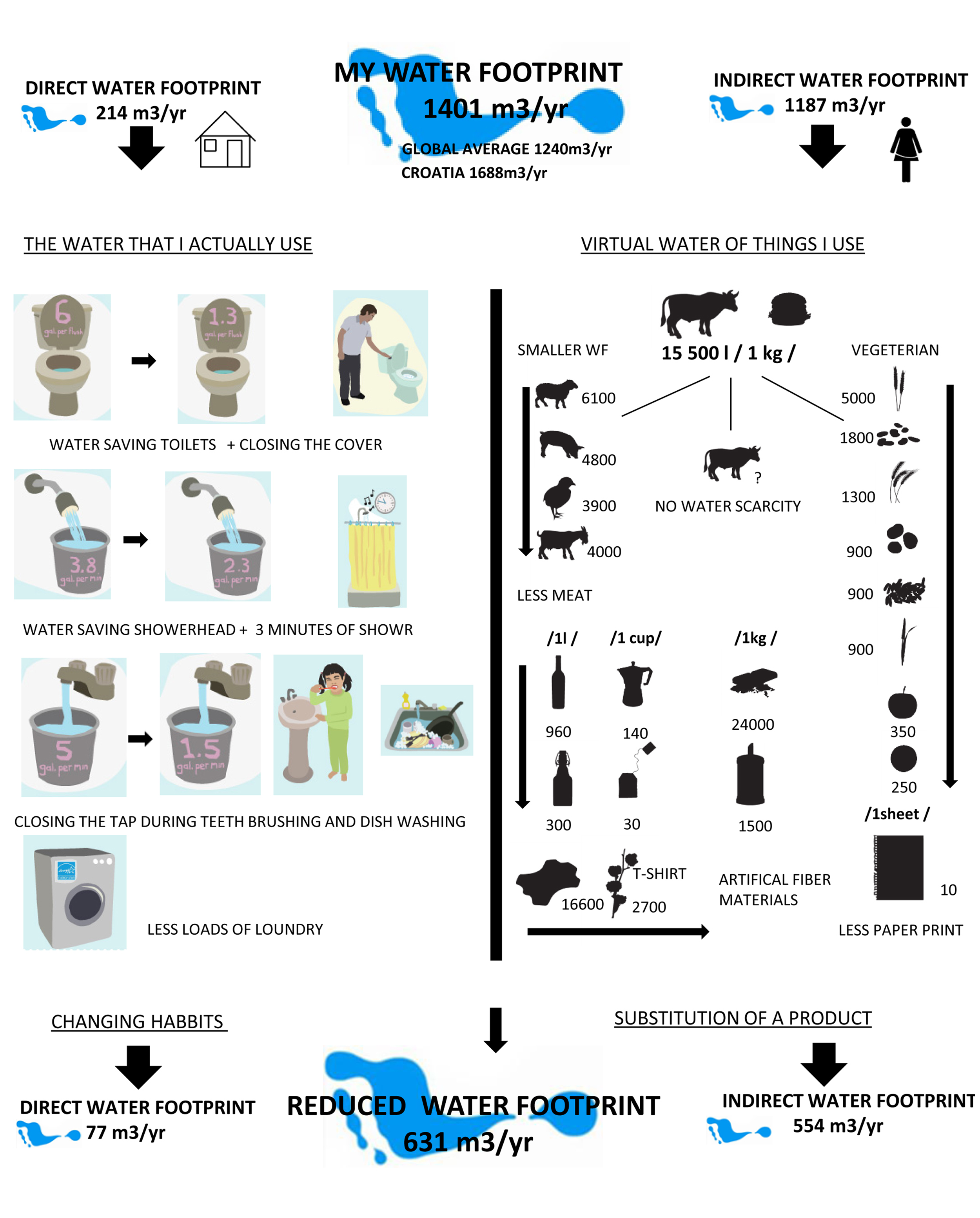
Which result have you got?
Let’s compare it with the water footprint calculation of one friend of mine, Croatian architect Ana Bilan that did some research in that field.
According to her calculations she was able to reduce her water footprint more than twice, which sounds really impressive! So it was a matter of changing her habits, decreasing the direct water footprint and also the types of food she eats and products she uses to get a better result with indirect water Footprint.
The people behind More Than Green have organized a great summer course on July 15-26, 2013 in the mediterranean city of Alicante (Spain), where we will also be taking part together with PLAYstudio, Transsolar and Urban Think Tank.
Sustainability is not just an environmental issue but, and above all, a social, cultural and economic one. This course about URBAN DESIGN and SUSTAINABLE ARCHITECTURE proposes a complex incursion within the subject of sustainability understood not only as a problem but as an opportunity to meet new approaches to the city in a creative, innovative, playful and unprejudiced way.
Contents + Objectives
Improve your design skills: based on an open criticism of the “only green” approach for the construction of our future sustainable cities, this course offers a much wider, complex and playful perspective at the same time. Students will combine the design of a team project –about an specific case‐ with the supervision of guest experts and their master classes.
Build a knowledge frame –examples of good practices told by guest experts‐ where students take consciousness of the importance of broadening their understanding of sustainability according to the new world policies.
Create a typical multicultural situation of an international course where students coming from different places exchange their various backgrounds and modes of undertaking the sustainable urban project. The diversity of the faculties contributes to enrich this situation.
Methodology + Course Structure
Master classes, teamwork and project reviews within the context of four different ways of understanding sustainability: ENVIRONMENTALLY, SOCIALLY, ECONOMICALLY and CULTURALLY.
Faculty
DIRECTOR: José Luis Oliver Ramírez (University of Alicante) + TRANSSOLAR: Matthias Schuler (Harvard GSD) + URBAN-THINK TANK: Alfredo Brillembourg (ETH Zurich) + ECOSISTEMA URBANO: Belinda Tato y Jose Luis Vallejo (Harvard GSD) + PLAYstudio: Iván Capdevila y Vicente Iborra (University of Alicante)
Alicante + Free time
It’s summer, you’re by the coast… who would dare to keep you away from having fun? Within the course structure, it is programmed a considerable amount of free time so the students can visit other cities or some interesting spots on the surroundings, enjoy the sun and the beach, or take part in different summer activities organized by the University of Alicante.
Acommodation
The University of Alicante offers you a wide range of facilities and affordable accommodation in several lovely locations from the historic city centre to the university campus surroundings.
Under the motto “The Sound of Cycling – Urban Cycling Cultures”, the Velo-city conference 2013 will take place this year in Vienna, a city that has been recognized for its efforts towards a highly livable and sustainable urban environment.
Velo-city conferences in general serve as a global communication and information platform aiming to address decision makers in order to improve the planning and provision of infrastructure for the everyday use of bicycles in urban environments. They typically bring together more than 1,000 delegates such as engineers, planners, architects, social marketers, academic researchers, environmentalists, businessmen/women, and industry representatives who join forces with government at all levels in order to build effective transnational partnerships to deliver benefits to cycling worldwide.
This year, the conference has been organized in three generic themes: cycling cultures, cycling cities and cycling benefits. It aims to offer a variety of inter- and trans-disciplinary approaches to cycling issues through different dialogue formats such as round tables, speed dating, open spaces and a world café, amongst others. To ensure a relaxed atmosphere and to facilitate networking, there will be also other activities like a Cycling Parade, a Bicycle Fashion Show, a Garden Party and some technical excursions.
In parallel to the conference, you can take part in the Cycling Visionaries Awards in the categories of Advocacy and Social Projects Science, Research and Development Design, Fashion and Cycling Equipment, Urban Planning and Urban Design Cycling and the Arts. We are curious about the entries, there’s quite a lot of innovation going on in the world of cycling but it’s not always visible to the general public.
On the conference’s website you can also read about some interesting cycling stories.
The trans-disciplinary research initiative “Low-Budget Urbanity. Frugal Practices Transforming the City” invites PhD and post-doctoral researchers to their first Early Career Laboratory from March 25th to 28th 2013 at HafenCity University in Hamburg.
Low-Budget Urbanity is a research programme that explores contemporary urban phenomena such as ridesharing and online hospitality networks, water-saving infrastructures and DIY-practices of house owners, and second-hand consumer cooperatives as saving practices that transform the urban setting. These self-organized saving practices all involve “complex encounters, connections and mixtures of diverse hybrid networks of humans and animals, objects and information, commodities and waste“ (Sheller and Urry 2006:2).
Public budgets are slashed, many cities are burdened with near-paralysing debt, and for private households, too, saving money often is less a virtue than the order of the day. As a search term of an exploratory and multidisciplinary research project, “low-budget urbanity” provides a relational perspective on those seemingly disparate austerity phenomena. The research focuses on the question of how these phenomena are transforming cities.
What is new is not that saving money constitutes a principle of individual practices (rationalized building, economic or political action, individual budget planning, etc.), but that the austerity imperative for the assemblage, i.e. the confluence and interaction of these principles has become a force that shapes and defines cities.
Next you can find a call for papers that many of you may find interesting, with the topic “What is the value of saving costs? The urban economics and politics of everyday saving practices”.
Do you have a dream about planting your own mango tree? The statistic probability that you who are reading this live in the city is over fifty percent, and the number is increasing. This means that fewer and fewer of us have the opportunity to grow our own fruit and vegetables, but are entirely dependent on the increasingly industrialized and transport-based large-scale agriculture.
Urban food production is a growing trend in many cities, and productive green spaces emerge on rooftops, in ditches, between buildings and on the left-over spaces without a specific use. The motives for cultivating food are diverse, some see it as part of a strategy to increase awareness and knowledge about the food we eat (food safety), others will create a focus on local food as one of the solutions to environmental challenges, while others grow their own garden just because it’s pleasure and to save money. Jennifer Cockrall-King claims in the book Food and the City that we are facing a food revolution as we have passed both the oil peak and peak water, and this begins to affect a growing global population:
Food and the City examines alternative food systems in cities around the globe that are shortening their food chains, growing food within their city limits, and taking their “food security” into their own hands.
In Oslo, Norway, urban farming occurs in a smaller scale, including the Geitmyra allotment garden where you can be assigned a soil patch for cultivation, and as guerrilla gardens, a more freely and actionist activity where the city’s leftover spaces are used for food production without formal permission of the landowners. The latest addition to this green trend where you can grow your own vegetables in Oslo is Herligheten (The Glory), an ecological initiative and project about urban food production initiated in April 2012 and developed during April and May 2012.
As part of a long-term development and urbanization of the waterfront in Oslo, the developer Bjørvika Utvikling has carried out several temporary projects from stunts to pavilions which have been standing there for a few years. The events and installations are bringing human activity into an area that for many years has been characterized by construction activities, but Herligheten differs from previous projects by a greater degree of activation of users and visitors, who are now shaping the new area of the city with green and consumable pleasures.
Herligheten is located at Loallmenningen in Bjørvika, a rocky “island” in the middle of a rough building site surrounded by roads, railway lines and the ventilation towers for the submerged tunnel underneath. It has found its home in an apparently gray and idle landscape between the Medieval park and the Oslo fjord, which has for many years been seen as a lifeless place in wait for better conditions. But during a few hectic weeks during spring the area has experienced a small, green revolution worked out by diligent volunteers who have transformed it into an oasis consisting of consumable plants, in what was previously a closed area for city residents.
As of today Herligheten consists of three main parts: Herligheten Allotment Garden with 100 allotments, a field measuring 250 m2 where several types of ancient grain such as spelt, emmer, einkorn and bere barley will grow, and an activity program consisting of a number of events and seminars for learning and exchanging ideas. As many as 3790 people applied in April to take part in Herligheten through the disposal of one of the 100 allotments, so it is clear that the people in Oslo have ambition to develop their green thumbs. We wish them good luck with the green revolution!
From the time of Heraclitus’ saying, “the only thing constant is change itself”, we have sought to make sense of our changing world. It can be argued that architecture in both the academic and professional realms is experiencing pressures as never before, and is shifting due to multiple factors. These forces include globalization, the expanding roles of technology, rapid urbanization, new energy policies, and regulatory agencies, among many others. What are the forces for change being exerted on our academic institutions and where do they come from? Are we still teaching in a way that is relevant to the contemporary practice of architecture, or perhaps we wish that practice would change?
The relationship between schools and the profession can be very permeable and often imprecise. Each informs the other, at times leading to greater relevance, at other times leaving disconcerting gaps. What role should schools and academics play in the face of our changing world? Will we be leaders or followers?
ACSA is The Association of Collegiate Schools of Architecture, a nonprofit, membership association founded in 1912 to advance the quality of architectural education. The 2012 ACSA International Conference will focus on CHANGE, and will explore these issues in relation to seven themes: Civic Engagement, Academia, Practice, Technology, Cities, Globalization, Sustainability and one flexible open category. The Co-chairs of the conference are Xavier Costa from Northeastern University and Martha Thorne, from IE University.
Review of the paper “Urban land teleconnections” by Karen C. Seto, Anette Reenberg, Christopher G. Boone, Michail Fragkias, Dagmar Haase, Tobias Langanke, Peter Marcotullio, Darla K. Munroe, Branislav Olah and David Simon.
Recently a research paper was published in Proceedings of the National Academy of Sciences (PNAS) concerning the conceptual development of global sustainability, in relation to both urbanization (urban sustainability) and land change. The paper argues that land change and urbanization dynamics are explicitly connected, and suggests “urban land teleconnections” as a new framework for dealing with global sustainability.
“We propose urban land teleconnections as a process-based framework for integrating urbanization and land change, for revealing their linkages and pathways across space and time, and for identifying potential intervention points for sustainability. Through the lens of urban land teleconnections, new and surprising diverse urban forms and processes, such as periurbanization, can be better understood and foreseen. The urban land teleconnections concept could also be useful to the wider research community to anticipate implications for global land resource use.”
More and more people live in the cities. The increasing urbanization is raising many discussions about sustainable planning, and this recently published paper feeds the debate with new inputs. Encouraging a reconsideration of the terms on which we base sustainable policies, the research is widening again our perception of the relationship between the urban field and land. The term “teleconnections” refers to climate science, where it is understood that events have impact over large geographic areas – when the waters of the North Atlantic go through a warm phase, fire incidents increase in the western United States. Just such urban land teleconnections explain the interrelation and invisible bond between urban processes and land use processes, which we must consider when planning our sustainable future. The key to develop strong sustainable planning, is to stop thinking of urban sustainability and land use sustainability as limited to local scale and place, and instead start to take into account the processes and global connections merging urbanization and land use.
“The virtual shrinking of distances between places, strengthening connectivity between distant locations, and growing separation between places of consumption and production are emerging topics in “telecoupled” human–natural systems and tropical teleconnections of deforestation […] In an increasingly urban world, characterized by global flows of commodities, capital, and people, where land that provides goods and ecosystems services for people is becoming more segregated from the space of habitation, teleconnections captures links between distant processes and places, and can be used to explore consequences of urbanization and land changes at great distances from points of origin that would otherwise go unrecognized.”
Urbanization and land change have so far been treated as parallel processes. Apparently this has limited the progress of the concept of sustainability. The paper states that a simultaneously treating of urban sustainability and land change as interwoven, non-separable processes is the keystone to advance in developing sustainability:
“The magnitude and accelerating rate of contemporary urbanization are reshaping land use locally and globally in ways that require a reexamination of land change and urban sustainability. Worldwide, urban populations are projected to increase by almost 3 billion by 2050 and the total global urban land area by more than 1.5 million square kilometers—an area three times the size of Spain—by 2030. Urban economies currently generate more than 90% of global gross value added, meaning few rural systems are unaffected by urbanization (3). Given such trends, we must reconsider how we conceptualize the many connections and feedbacks between urbanization and land change processes.”
The paper is confronting three understandings of the urban – land relationship that so far have been key themes in sustainability policies.
One is the Land Classification Systems, on which the paper states:
“By definition, because urban is human-dominated, urban areas “appropriate” natural ecosystems, ecosystem services, and natural capital. By this logic, urban cannot be natural capital. However, such a conceptualization contradicts underlying principles of urban ecology as well as sustainability.”
The second theme is Place-Based Definitions:
“The place-based conceptualization enforces the idea that urban sustainability requires urban self-sufficiency. […] However, decisions and behaviors that are local or even regional in scope do not account for critical consequences of teleconnections, which may undermine sustainability efforts at great distances or influence the overall sustainability for the entire system. Eating locally might undermine livelihoods of distant farmers who may be using less energy-intensive methods to produce food than local growers. Put another way, sustainability initiatives often focus on the importance of place while ignoring the processes of urbanization that may have farreaching effects on distant places and people. These processes can generate uneven and undesirable outcomes that may be undetected when focusing solely on place.”
On the third theme, Land Transitions, the paper argues:
“[…] Although not always explicit, a common assumption is that land transitions in Europe and North America can help understand future trends in Asia, South America, and Africa. Such assumptions disregard the realities that cultural differences influence conceptions, codifications, and uses of space and land, and that use of distant land to meet demand for local populations can significantly alter the pathways of change. As a result, there is no universal or linear transition process; phases identified in one context can be shortened, prolonged, overlapped, or even omitted or transgressed elsewhere.”
Urban Land Teleconnections is suggested as a new key theme, a framework to address sustainability. In an immediate invisible network, urbanization and land change are constantly in a process of affecting one another. The term itself indicates that the concept of sustainable urbanization and sustainable land use has merged. Conceptualization of sustainability should contain both processes at once.
“By using an urban land teleconnections framework, we move away from conceptualizing urban sustainability and land as attributes specific only to a place, to begin to link dynamic global processes to their spatial “imprint”.”
This means that changes in nonurban places affects urban places and that change in urban space affects nonurban space. In this way, urban and land relations are interwoven in a global network wherein neither the themes Land Classification Systems, Place-Based Definitions nor Land Transitions can stand alone to define the framework for developing sustainable concepts.
“ […] we can study multiple urban regions jointly, rather than trying to aggregate and generalize across many disconnected sets of case studies, and consequently provide a more organized way to integrate knowledge globally. A more holistic analysis of the underlying and spatial effects of production, consumption, and disposal will enable development of policies that promote viable and fair solutions, and ultimately global sustainability.”